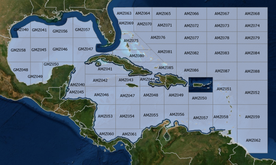
Hover to view popup zone forecast; click a zone to view related text forecast below. Show All Text Below
000
FZNT23 KNHC 200838
OFFNT3

Offshore Waters Forecast for the Caribbean Sea and Tropical
N Atlantic
NWS National Hurricane Center Miami, FL
438 AM EDT Mon May 20 2024

Offshore Waters Forecast for Caribbean Sea, and the Tropical N
Atlantic from 07N to 19N W of 55W.

Seas given as significant wave height, which is the average
height of the highest 1/3 of the waves. Individual waves may be
more than twice the significant wave height.
AMZ001-202045-
Synopsis for Caribbean Sea, and Tropical N Atlantic from 07N to
19N W of 55W
438 AM EDT Mon May 20 2024

.SYNOPSIS...A weak Atlantic surface ridge prevails N of the area.
The associated pressure gradient between the ridge and lower
pressure over northern South America is supporting fresh to
strong E winds in the south-central Caribbean. These winds in the
will shift eastward to offshore of NW Venezuela through Tue night
and diminish early on Wed. A deep layer trough will dig southward
across the western Caribbean Mon night through Fri, supporting
active weather E of 80W Tue through Fri. Fresh to strong E to SE
winds will develop in the central Caribbean Tue and shift eastward
through Thu while diminishing to mostly fresh speeds. Smoke due
to agricultural fires in Central America continues across the Gulf
of Honduras, but continue to thin out.
AMZ040-202045-
Caribbean N of 18N W of 85W including Yucatan Basin-
438 AM EDT Mon May 20 2024

.TODAY...SE winds 10 to 15 kt. Seas 3 to 5 ft.
.TONIGHT...E to SE winds 10 to 15 kt. Seas 2 to 4 ft.
.TUE...E to SE winds 10 to 15 kt. Seas 2 to 4 ft.
.TUE NIGHT...E to SE winds 10 to 15 kt. Seas 2 to 4 ft.
.WED...E to SE winds 10 to 15 kt. Seas 2 to 4 ft.
.WED NIGHT...E to SE winds 15 to 20 kt S of 20N, and E to SE
10 to 15 kt N of 20N. Seas 2 to 4 ft.
.THU...E to SE winds 10 to 15 kt. Seas 2 to 4 ft.
.THU NIGHT...E to SE winds 15 kt S of 20N, and E to SE 10 to
15 kt N of 20N. Seas 2 to 4 ft.
.FRI...E to SE winds 10 to 15 kt. Seas 2 to 4 ft.
.FRI NIGHT...E to SE winds 15 to 20 kt S of 20N, and E to SE
10 to 15 kt N of 20N. Seas 2 to 4 ft.
Forecaster ERA
AMZ041-202045-
Caribbean N of 20N E of 85W-
438 AM EDT Mon May 20 2024

.TODAY...SE winds 10 kt W of 81W, and variable less than 5 kt E
of 81W. Seas 2 to 4 ft.
.TONIGHT...Variable winds less than 5 kt, becoming E 10 kt late.
Seas 3 ft or less.
.TUE...E to SE winds 10 kt W of 81W, and variable less than 5 kt
E of 81W. Seas 3 ft or less.
.TUE NIGHT...E to SE winds 10 kt. Seas 2 to 4 ft.
.WED...E winds 10 kt. Seas 3 to 5 ft.
.WED NIGHT...E to SE winds 10 kt. Seas 4 to 6 ft in SE swell.
.THU...W of 81W, E to SE winds 10 kt. E of 81W, NE to E winds
10 kt in the morning, becoming variable less than 5 kt. Seas 4 to
6 ft in SE swell.
.THU NIGHT...W of 81W, E to SE winds 10 kt. E of 81W, variable
winds less than 5 kt, becoming NE to E 10 kt late. Seas
3 to 5 ft.
.FRI...E to SE winds 10 kt. Seas 2 to 4 ft.
.FRI NIGHT...W of 81W, E to SE winds 10 kt. E of 81W, variable
winds less than 5 kt, becoming E 10 kt late. Seas 2 to
4 ft.
Forecaster ERA
AMZ042-202045-
Caribbean from 18N to 20N between 80W and 85W including Cayman
Basin-
438 AM EDT Mon May 20 2024

.TODAY...E to SE winds 10 to 15 kt. Seas 2 to 4 ft.
.TONIGHT...E winds 10 to 15 kt. Seas 2 to 4 ft.
.TUE...E to SE winds 10 to 15 kt. Seas 2 to 4 ft.
.TUE NIGHT...E winds 10 to 15 kt. Seas 2 to 4 ft.
.WED...E winds 10 to 15 kt. Seas 3 to 5 ft.
.WED NIGHT...E to SE winds 10 to 15 kt. Seas 4 to 6 ft.
.THU...E to SE winds 10 kt. Seas 4 to 6 ft in E to SE swell.
.THU NIGHT...E winds 10 to 15 kt. Seas 3 to 5 ft.
.FRI...E winds 10 kt. Seas 2 to 4 ft.
.FRI NIGHT...E to SE winds 10 to 15 kt. Seas 2 to 4 ft.
Forecaster ERA
AMZ043-202045-
Caribbean from 18N to 20N between 76W and 80W-
438 AM EDT Mon May 20 2024

.TODAY...E to SE winds 10 to 15 kt. Seas 3 to 5 ft.
.TONIGHT...E winds 10 to 15 kt. Seas 4 to 6 ft.
.TUE...E to SE winds 10 to 15 kt. Seas 4 to 6 ft.
.TUE NIGHT...E winds 10 to 15 kt W of 78W, and E to SE 15 to
20 kt E of 78W. Seas 5 to 7 ft in E to SE swell. Scattered
showers and isolated tstms.
.WED...E winds 10 to 15 kt W of 78W, and E to SE 15 to 20 kt E of
78W. Seas 6 to 8 ft in E to SE swell.
.WED NIGHT...E to SE winds 10 to 15 kt. Seas 6 to 8 ft in E to SE
swell.
.THU...W of 78W, NE to E winds 10 kt. E of 78W, E winds 10 kt in
the morning, becoming variable less than 5 kt. Seas 5 to 7 ft in
E to SE swell.
.THU NIGHT...W of 78W, variable winds less than 5 kt, becoming NE
to E 10 kt late. E of 78W, variable winds less than
5 kt. Seas 3 to 5 ft.
.FRI...E to SE winds 10 kt. Seas 2 to 4 ft.
.FRI NIGHT...W of 78W, variable winds less than 5 kt, becoming E
10 kt late. E of 78W, E to SE winds 10 kt. Seas 2 to
4 ft.
Forecaster ERA
AMZ044-202045-
Caribbean approaches to the Windward Passage-
438 AM EDT Mon May 20 2024

.TODAY...In the Gulf of Gonave, variable winds less than 5 kt.
Elsewhere, E to SE winds 10 kt, shifting to SE to S in the
afternoon. Seas 3 to 5 ft.
.TONIGHT...In the Gulf of Gonave, W to NW winds 10 kt in the
evening, becoming variable less than 5 kt. Elsewhere, S winds
10 to 15 kt, shifting to N to NE late. Seas 4 to 6 ft
in SE to S swell.
.TUE...In the Gulf of Gonave, variable winds less than 5 kt.
Elsewhere, NE winds 10 to 15 kt, shifting to SE in the afternoon.
Seas 4 to 6 ft in S swell.
.TUE NIGHT...Variable winds less than 5 kt in the Gulf of Gonave,
and E 10 to 15 kt elsewhere. Seas 5 to 7 ft in SE to S swell.
Scattered showers and isolated tstms.
.WED...In the Gulf of Gonave, SE winds 10 to 15 kt. Seas 3 ft or
less. Elsewhere, SE winds 20 to 25 kt. Seas 6 to 8 ft.
.WED NIGHT...E winds 10 to 15 kt. Seas 3 ft or less in the Gulf
of Gonave, and 6 to 8 ft elsewhere.
.THU...NE to E winds 10 kt. Seas 3 ft or less in the Gulf of
Gonave, and 5 to 7 ft elsewhere.
.THU NIGHT...NE to E winds 10 to 15 kt. Seas 3 ft or less in the
Gulf of Gonave, and 3 to 5 ft elsewhere.
.FRI...NE to E winds 10 kt. Seas 3 ft or less in the Gulf of
Gonave, and 3 to 5 ft elsewhere.
.FRI NIGHT...NE to E winds 10 to 15 kt. Seas 2 to 4 ft.
Forecaster ERA
AMZ045-202045-
S of 18N W of 85W including Gulf of Honduras-
438 AM EDT Mon May 20 2024

.TODAY...E winds 15 to 20 kt. Seas 4 to 6 ft.
.TONIGHT...E winds 15 kt. Seas 2 to 4 ft.
.TUE...E winds 10 to 15 kt. Seas 3 to 5 ft.
.TUE NIGHT...E winds 15 kt. Seas 2 to 4 ft.
.WED...E winds 10 to 15 kt. Seas 2 to 4 ft.
.WED NIGHT...E winds 15 to 20 kt. Seas 2 to 4 ft.
.THU...E winds 10 to 15 kt. Seas 2 to 4 ft.
.THU NIGHT...E winds 15 to 20 kt. Seas 3 to 5 ft.
.FRI...E winds 10 to 15 kt. Seas 3 to 5 ft.
.FRI NIGHT...E winds 15 to 20 kt. Seas 3 to 5 ft.
Forecaster ERA
AMZ046-202045-
Caribbean from 15N to 18N between 80W and 85W-
438 AM EDT Mon May 20 2024

.TODAY...E winds 10 to 15 kt. Seas 4 to 6 ft.
.TONIGHT...E winds 10 to 15 kt. Seas 4 to 6 ft.
.TUE...E winds 10 to 15 kt. Seas 4 to 6 ft.
.TUE NIGHT...E winds 10 to 15 kt. Seas 4 to 6 ft.
.WED...E winds 10 to 15 kt. Seas 2 to 4 ft W of 82W, and 4 to
6 ft E of 82W.
.WED NIGHT...E winds 15 to 20 kt. Seas 3 to 5 ft W of 82W, and
4 to 6 ft E of 82W.
.THU...E winds 10 to 15 kt. Seas 3 to 5 ft W of 82W, and 4 to
6 ft E of 82W.
.THU NIGHT...E winds 10 to 15 kt. Seas 2 to 4 ft W of 82W, and
3 to 5 ft E of 82W.
.FRI...W of 82W, E to SE winds 10 to 15 kt. E of 82W, E to SE
winds 10 kt in the morning, becoming variable less than 5 kt.
Seas 2 to 4 ft.
.FRI NIGHT...E to SE winds 10 to 15 kt. Seas 2 to 4 ft W of 82W,
and 3 ft or less E of 82W.
Forecaster ERA
AMZ047-202045-
Caribbean from 15N to 18N between 76W and 80W-
438 AM EDT Mon May 20 2024

.TODAY...E winds 15 to 20 kt. Seas 5 to 7 ft.
.TONIGHT...E winds 15 to 20 kt S of 17N, and E 10 to 15 kt N of
17N. Seas 5 to 7 ft.
.TUE...E winds 15 to 20 kt S of 17N, and E 10 to 15 kt N of 17N.
Seas 6 to 8 ft. Scattered showers and isolated tstms.
.TUE NIGHT...E winds 15 to 20 kt. Seas 6 to 8 ft in E to SE
swell. Scattered showers and isolated tstms.
.WED...S of 17N, E to SE winds 10 to 15 kt, becoming E 20 to
25 kt in the afternoon. N of 17N, E winds 20 to 25 kt. Seas 6 to
9 ft in E to SE swell.
.WED NIGHT...E winds 15 to 20 kt, diminishing to 10 kt late. Seas
6 to 9 ft in E swell.
.THU...E winds 10 kt. Seas 5 to 7 ft in E to SE swell.
.THU NIGHT...NE to E winds 10 kt. Seas 3 to 5 ft.
.FRI...E to SE winds 10 kt. Seas 3 to 5 ft.
.FRI NIGHT...E winds 10 kt. Seas 2 to 4 ft.
Forecaster ERA
AMZ048-202045-
Caribbean from 15N to 18N between 72W and 76W-
438 AM EDT Mon May 20 2024

.TODAY...E winds 15 to 20 kt. Seas 6 to 8 ft in E to SE swell.
.TONIGHT...E winds 15 to 20 kt. Seas 6 to 8 ft in E to SE swell.
.TUE...E winds 15 to 20 kt. Seas 6 to 8 ft in E to SE swell.
Scattered showers and isolated tstms.
.TUE NIGHT...E to SE winds 20 kt. Seas 6 to 9 ft in E to SE
swell. Numerous showers and scattered tstms.
.WED...Winds E winds 20 to 25 kt. Seas 6 to 9 ft in E to SE
swell.
.WED NIGHT...S of 17N, NE to E winds 20 to 25 kt, becoming E
10 to 15 kt late. N of 17N, E winds 15 to 20 kt. Seas
6 to 9 ft in E to SE swell.
.THU...E winds 10 kt. Seas 5 to 7 ft in E to SE swell.
.THU NIGHT...NE to E winds 10 kt. Seas 4 to 6 ft in E to SE
swell.
.FRI...E winds 10 kt. Seas 3 to 5 ft.
.FRI NIGHT...E winds 10 kt. Seas 2 to 4 ft.
Forecaster ERA
AMZ049-202045-
Caribbean N of 15N between 68W and 72W-
438 AM EDT Mon May 20 2024

.TODAY...E to SE winds 15 to 20 kt. Seas 6 to 8 ft.
.TONIGHT...E winds 15 to 20 kt. Seas 6 to 8 ft in SE swell.
.TUE...E to SE winds 15 to 20 kt. Seas 6 to 8 ft in SE swell.
Scattered showers and isolated tstms.
.TUE NIGHT...E to SE winds 15 to 20 kt W of 70W, and E to SE
10 to 15 kt E of 70W. Seas 6 to 8 ft in SE swell. Scattered
tstms.
.WED...E winds 20 to 25 kt W of 70W, and E 10 to 15 kt E of 70W.
Seas 6 to 8 ft in E to SE swell.
.WED NIGHT...E winds 15 to 20 kt. Seas 5 to 7 ft.
.THU...E to SE winds 10 to 15 kt W of 70W, and SE 15 to 20 kt E
of 70W. Seas 5 to 7 ft.
.THU NIGHT...E to SE winds 10 kt. Seas 4 to 6 ft in E to SE
swell.
.FRI...E to SE winds 10 kt. Seas 3 to 5 ft.
.FRI NIGHT...E winds 10 kt. Seas 3 to 5 ft.
Forecaster ERA
AMZ050-202045-
Caribbean N of 15N between 64W and 68W-
438 AM EDT Mon May 20 2024

.TODAY...E to SE winds 15 kt. Seas 4 to 6 ft.
.TONIGHT...E to SE winds 15 to 20 kt. Seas 4 to 6 ft.
.TUE...E to SE winds 15 to 20 kt. Seas 4 to 6 ft.
.TUE NIGHT...E to SE winds 10 to 15 kt. Seas 4 to 6 ft. Scattered
showers and isolated tstms.
.WED...E to SE winds 10 to 15 kt. Seas 4 to 6 ft.
.WED NIGHT...E winds 15 to 20 kt. Seas 4 to 6 ft.
.THU...SE winds 15 to 20 kt W of 66W, and E to SE 15 kt E of 66W.
Seas 4 to 6 ft.
.THU NIGHT...E to SE winds 10 to 15 kt. Seas 4 to 6 ft.
.FRI...SE winds 10 to 15 kt. Seas 3 to 5 ft.
.FRI NIGHT...E to SE winds 10 to 15 kt. Seas 3 to 5 ft.
Forecaster ERA
AMZ051-202045-
Offshore Waters Leeward Islands-
438 AM EDT Mon May 20 2024

.TODAY...E to SE winds 10 to 15 kt. Seas 3 to 5 ft.
.TONIGHT...E to SE winds 10 to 15 kt. Seas 3 to 5 ft.
.TUE...E to SE winds 10 to 15 kt. Seas 3 to 5 ft.
.TUE NIGHT...E to SE winds 15 kt. Seas 4 to 6 ft.
.WED...E to SE winds 15 kt. Seas 5 to 7 ft.
.WED NIGHT...E winds 15 kt. Seas 5 to 7 ft.
.THU...E to SE winds 10 to 15 kt. Seas 4 to 6 ft.
.THU NIGHT...E to SE winds 10 to 15 kt. Seas 4 to 6 ft.
.FRI...SE winds 10 to 15 kt. Seas 4 to 6 ft.
.FRI NIGHT...E to SE winds 10 kt. Seas 3 to 5 ft.
Forecaster ERA
AMZ052-202045-
Tropical N Atlantic from 15N to 19N between 55W and 60W-
438 AM EDT Mon May 20 2024

.TODAY...E winds 10 to 15 kt. Seas 3 to 5 ft.
.TONIGHT...E winds 10 to 15 kt. Seas 3 to 5 ft.
.TUE...E to SE winds 15 kt. Seas 4 to 6 ft.
.TUE NIGHT...E winds 15 kt. Seas 4 to 6 ft.
.WED...E winds 15 kt. Seas 5 to 7 ft.
.WED NIGHT...E winds 15 kt. Seas 5 to 7 ft in E swell.
.THU...E winds 15 kt. Seas 5 to 7 ft in E swell.
.THU NIGHT...E to SE winds 15 kt. Seas 4 to 6 ft.
.FRI...E to SE winds 10 to 15 kt. Seas 4 to 6 ft.
.FRI NIGHT...E to SE winds 10 to 15 kt. Seas 4 to 6 ft.
Forecaster ERA
AMZ053-202045-
W Central Caribbean from 11N to 15N W of 80W-
438 AM EDT Mon May 20 2024

.TODAY...NE to E winds 10 to 15 kt. Seas 4 to 6 ft. Scattered
showers and isolated tstms.
.TONIGHT...NE to E winds 10 to 15 kt. Seas 4 to 6 ft. Scattered
showers and isolated tstms.
.TUE...NE to E winds 10 to 15 kt. Seas 4 to 6 ft.
.TUE NIGHT...NE to E winds 10 to 15 kt. Seas 4 to 6 ft.
.WED...N to NE winds 10 kt. Seas 4 to 6 ft in E swell.
.WED NIGHT...NE to E winds 10 to 15 kt. Seas 3 to 5 ft.
.THU...E winds 10 kt. Seas 3 to 5 ft.
.THU NIGHT...NE to E winds 10 kt. Seas 2 to 4 ft.
.FRI...In the reefs, variable winds less than 5 kt, becoming E to
SE 10 kt in the afternoon. In the open waters, variable winds
less than 5 kt. Seas 2 to 4 ft.
.FRI NIGHT...E winds 10 kt. Seas 3 ft or less.
Forecaster ERA
AMZ054-202045-
Caribbean from 11N to 15N between 76W and 80W-
438 AM EDT Mon May 20 2024

.TODAY...NE to E winds 15 to 20 kt. Seas 6 to 9 ft in E swell.
.TONIGHT...NE to E winds 15 to 20 kt W of 78W, and E 15 to 20 kt
E of 78W. Seas 6 to 8 ft in E swell. Scattered showers and
isolated tstms.
.TUE...E to SE winds 15 to 20 kt. Seas 6 to 8 ft in NE to E
swell. Scattered showers and isolated tstms.
.TUE NIGHT...SE winds 10 to 15 kt. Seas 6 to 8 ft in NE to E
swell. Scattered showers and isolated tstms.
.WED...SE to S winds 10 kt. Seas 5 to 7 ft in NE to E swell.
.WED NIGHT...E winds 10 to 15 kt. Seas 5 to 7 ft in NE to E
swell.
.THU...W of 78W, E to SE winds 10 kt. E of 78W, E to SE winds
10 kt in the morning, becoming variable less than 5 kt. Seas 4 to
6 ft.
.THU NIGHT...NE winds 10 kt. Seas 3 to 5 ft.
.FRI...E winds 10 kt. Seas 2 to 4 ft.
.FRI NIGHT...W of 78W, NE to E winds 10 kt. E of 78W, variable
winds less than 5 kt, becoming NE to E 10 kt late. Seas
2 to 4 ft.
Forecaster ERA
AMZ055-202045-
Caribbean from 11N to 15N between 72W and 76W including Colombia
Basin-
438 AM EDT Mon May 20 2024

.TODAY...NE to E winds 20 to 25 kt S of 13N, and E 20 to 25 kt N
of 13N. Seas 6 to 9 ft in E swell.
.TONIGHT...NE to E winds 15 to 20 kt S of 13N, and E 20 to 25 kt
N of 13N. Seas 6 to 9 ft in NE to E swell. Scattered showers and
isolated tstms.
.TUE...SE to S winds 15 to 20 kt S of 13N, and E to SE 20 to
25 kt N of 13N. Seas 6 to 9 ft in NE to E swell. Scattered
showers and isolated tstms.
.TUE NIGHT...S of 13N, S winds 10 kt, shifting to E to SE late. N
of 13N, E to SE winds 15 to 20 kt. Seas 6 to 8 ft in
NE to E swell. Scattered showers and isolated tstms.
.WED...E to SE winds 10 to 15 kt S of 13N, and E to SE 15 to
20 kt N of 13N. Seas 6 to 8 ft in NE to E swell.
.WED NIGHT...S of 13N, N to NE winds 10 kt, shifting to E late. N
of 13N, E winds 15 to 20 kt. Seas 6 to 8 ft in NE to
E swell.
.THU...SE winds 10 kt in the morning, becoming variable less than
5 kt. Seas 5 to 7 ft in NE to E swell.
.THU NIGHT...S of 13N, variable winds less than 5 kt. N of 13N,
variable winds less than 5 kt, becoming NE to E 10 kt late. Seas
4 to 6 ft in NE to E swell.
.FRI...S of 13N, E winds 10 kt in the morning, becoming variable
less than 5 kt. N of 13N, E winds 10 kt. Seas 3 to 5 ft in NE to
E swell.
.FRI NIGHT...NE to E winds 10 kt. Seas 2 to 4 ft.
Forecaster ERA
AMZ056-202045-
Caribbean S of 15N between 68W and 72W including Gulf of
Venezuela-
438 AM EDT Mon May 20 2024

.TODAY...E winds 20 to 25 kt. Seas 6 to 9 ft in E swell.
.TONIGHT...E winds 20 to 25 kt. Seas 6 to 9 ft in E swell.
.TUE...E to SE winds 20 to 25 kt. Seas 6 to 9 ft in E swell.
Scattered showers and isolated tstms.
.TUE NIGHT...E winds 15 to 20 kt. Seas 6 to 8 ft in E swell.
Scattered showers and isolated tstms.
.WED...Winds E winds 15 to 20 kt. Seas 6 to 8 ft in E swell.
.WED NIGHT...E winds 15 to 20 kt S of 13N, and E to SE 15 to
20 kt N of 13N. Seas 5 to 7 ft.
.THU...E to SE winds 10 to 15 kt S of 13N, and SE 15 to 20 kt N
of 13N. Seas 4 to 6 ft.
.THU NIGHT...E winds 10 to 15 kt. Seas 4 to 6 ft.
.FRI...E winds 10 to 15 kt. Seas 3 to 5 ft.
.FRI NIGHT...E winds 10 to 15 kt. Seas 3 to 5 ft.
Forecaster ERA
AMZ057-202045-
Caribbean S of 15N between 64W and 68W including Venezuela Basin-
438 AM EDT Mon May 20 2024

.TODAY...E winds 15 to 20 kt. Seas 5 to 7 ft.
.TONIGHT...E winds 15 to 20 kt. Seas 5 to 7 ft. Scattered showers
and isolated tstms.
.TUE...E winds 15 to 20 kt. Seas 5 to 7 ft.
.TUE NIGHT...E winds 15 to 20 kt. Seas 4 to 6 ft. Scattered
showers and isolated tstms.
.WED...E to SE winds 15 to 20 kt. Seas 4 to 6 ft.
.WED NIGHT...E winds 15 to 20 kt. Seas 4 to 6 ft.
.THU...E to SE winds 15 to 20 kt. Seas 4 to 6 ft.
.THU NIGHT...E winds 15 kt. Seas 4 to 6 ft.
.FRI...E winds 10 to 15 kt. Seas 3 to 5 ft.
.FRI NIGHT...E winds 10 to 15 kt. Seas 3 to 5 ft.
Forecaster ERA
AMZ058-202045-
Offshore Waters Windward Islands including Trinidad and Tobago-
438 AM EDT Mon May 20 2024

.TODAY...E winds 10 to 15 kt. Seas 3 to 5 ft.
.TONIGHT...E winds 15 to 20 kt. Seas 3 to 5 ft.
.TUE...E to SE winds 10 to 15 kt. Seas 3 to 5 ft.
.TUE NIGHT...E winds 15 to 20 kt. Seas 3 to 5 ft.
.WED...E to SE winds 10 to 15 kt. Seas 4 to 6 ft.
.WED NIGHT...E to SE winds 10 to 15 kt. Seas 4 to 6 ft.
.THU...E to SE winds 10 to 15 kt. Seas 4 to 6 ft.
.THU NIGHT...E to SE winds 10 to 15 kt. Seas 4 to 6 ft.
.FRI...E to SE winds 10 to 15 kt. Seas 4 to 6 ft.
.FRI NIGHT...E winds 10 to 15 kt. Seas 3 to 5 ft.
Forecaster ERA
AMZ059-202045-
Tropical N Atlantic from 11N and 15N between 55W and 60W-
438 AM EDT Mon May 20 2024

.TODAY...E winds 10 to 15 kt. Seas 4 to 6 ft.
.TONIGHT...E winds 15 kt. Seas 3 to 5 ft.
.TUE...E to SE winds 15 kt. Seas 4 to 6 ft.
.TUE NIGHT...E winds 15 kt. Seas 4 to 6 ft. Scattered showers and
isolated tstms.
.WED...E winds 15 kt. Seas 5 to 7 ft.
.WED NIGHT...E winds 15 kt. Seas 5 to 7 ft in E swell.
.THU...E winds 10 to 15 kt. Seas 4 to 6 ft.
.THU NIGHT...E winds 10 to 15 kt. Seas 4 to 6 ft.
.FRI...E winds 10 to 15 kt. Seas 4 to 6 ft.
.FRI NIGHT...E winds 10 to 15 kt. Seas 4 to 6 ft.
Forecaster ERA
AMZ060-202045-
SW Caribbean S of 11N W of 80W-
438 AM EDT Mon May 20 2024

.TODAY...N winds 10 kt. Seas 4 to 6 ft in NE to E swell.
Scattered showers and isolated tstms.
.TONIGHT...S of 10N, NW winds 10 kt. N of 10N, N winds 10 kt in
the evening, becoming variable less than 5 kt. Seas 3 to 5 ft.
Scattered showers and isolated tstms.
.TUE...NW winds 10 kt. Seas 3 to 5 ft. Scattered showers and
isolated tstms.
.TUE NIGHT...S of 10N, W winds 10 kt. N of 10N, NW winds 10 kt in
the evening, becoming variable less than 5 kt. Seas 2 to 4 ft.
Scattered showers and isolated tstms.
.WED...W winds 10 kt. Seas 2 to 4 ft.
.WED NIGHT...Variable winds less than 5 kt. Seas 2 to 4 ft in NE
to E swell.
.THU...Variable winds less than 5 kt. Seas 3 ft or less in NE to
E swell.
.THU NIGHT...Variable winds less than 5 kt. Seas 3 ft or less in
NE to E swell.
.FRI...Variable winds less than 5 kt. Seas 3 ft or less in NE
swell.
.FRI NIGHT...Variable winds less than 5 kt. Seas 3 ft or less.
Forecaster ERA
AMZ061-202045-
SW Caribbean S of 11N E of 80W including the approaches to the
Panama Canal-
438 AM EDT Mon May 20 2024

.TODAY...NE winds 10 kt, shifting to W in the afternoon. Seas
5 to 7 ft in NE swell. Scattered showers and isolated tstms.
.TONIGHT...S of 10N, SW to W winds 10 to 15 kt. N of 10N,
variable winds less than 5 kt, becoming SW 10 kt late.
Seas 4 to 6 ft in NE swell. Numerous showers and scattered tstms.
.TUE...S to SW winds 10 kt. Seas 3 to 5 ft. Numerous showers and
scattered tstms.
.TUE NIGHT...S to SW winds 10 to 15 kt. Seas 3 to 5 ft. Scattered
showers and isolated tstms.
.WED...S to SW winds 10 kt. Seas 2 to 4 ft.
.WED NIGHT...Variable winds less than 5 kt. Seas 2 to 4 ft in NE
swell.
.THU...S of 10N, SE to S winds 10 kt in the morning, becoming
variable less than 5 kt. N of 10N, variable winds less than 5 kt.
Seas 3 ft or less in NE swell.
.THU NIGHT...Variable winds less than 5 kt. Seas 3 ft or less in
NE swell.
.FRI...Variable winds less than 5 kt. Seas 3 ft or less in NE
swell.
.FRI NIGHT...Variable winds less than 5 kt. Seas 3 ft or less in
NE swell, subsiding to 3 ft or less late.
Forecaster ERA
AMZ062-202045-
Tropical N Atlantic from 7N and 11N between 55W and 60W-
438 AM EDT Mon May 20 2024

.TODAY...E winds 10 to 15 kt. Seas 3 to 5 ft.
.TONIGHT...E winds 15 kt. Seas 3 to 5 ft.
.TUE...E winds 10 to 15 kt. Seas 3 to 5 ft. Scattered showers and
isolated tstms.
.TUE NIGHT...E winds 15 kt. Seas 4 to 6 ft. Scattered showers and
isolated tstms.
.WED...E winds 15 kt. Seas 4 to 6 ft.
.WED NIGHT...E winds 15 kt. Seas 4 to 6 ft.
.THU...E winds 10 to 15 kt. Seas 4 to 6 ft.
.THU NIGHT...NE to E winds 10 to 15 kt. Seas 4 to 6 ft.
.FRI...E winds 10 kt S of 09N, and E 10 to 15 kt N of 09N. Seas
4 to 6 ft.
.FRI NIGHT...E winds 10 to 15 kt. Seas 4 to 6 ft.
Forecaster ERA
000
FZNT25 KNHC 200837
OFFNT5

Offshore Waters Forecast for the SW N Atlantic including the
Bahamas
NWS National Hurricane Center Miami, FL
437 AM EDT Mon May 20 2024

Offshore Waters Forecast for the SW N Atlantic from 19N to 31N W
of 55W including Bahamas.

Seas given as significant wave height, which is the average
height of the highest 1/3 of the waves. Individual waves may be
more than twice the significant wave height.
AMZ101-202045-
Synopsis for the SW N Atlantic including the Bahamas
437 AM EDT Mon May 20 2024

.SYNOPSIS...Scattered showers and thunderstorms prevail across
the western Atlantic W of 70W in the vicinity of a cold front
and pre-frontal trough. The front will move southeastward and
stall from near 31N72W to SE Florida late Tue. A trough will
develop southeast of the weakening front and extend into the
central Bahamas early on Wed, and drift eastward through Fri
night. Fresh winds and moderate seas will prevail in the western
Atlantic with the front/trough through midweek, then light to
gentle winds and slight seas are expected through Fri.
AMZ063-202045-
Atlantic from 29N to 31N W of 77W-
437 AM EDT Mon May 20 2024

.TODAY...N winds 10 to 15 kt. Seas 3 to 5 ft. Scattered showers
and isolated tstms.
.TONIGHT...NE winds 15 to 20 kt. Seas 4 to 6 ft. Scattered
tstms.
.TUE...NE to E winds 10 to 15 kt. Seas 3 to 5 ft. Scattered
tstms.
.TUE NIGHT...NE to E winds 10 to 15 kt. Seas 3 to 5 ft.
Scattered tstms.
.WED...NE winds 10 kt. Seas 2 to 4 ft.
.WED NIGHT...E winds 10 kt. Seas 2 to 4 ft.
.THU...Variable winds less than 5 kt. Seas 3 ft or less.
.THU NIGHT...E to SE winds 10 kt. Seas 3 ft or less.
.FRI...Variable winds less than 5 kt. Seas 3 ft or less.
.FRI NIGHT...SE to S winds 10 to 15 kt. Seas 3 ft or less.
Forecaster ERA
AMZ064-202045-
Atlantic from 29N to 31N between 74W and 77W-
437 AM EDT Mon May 20 2024

.TODAY...W to NW winds 10 kt. Seas 3 to 5 ft. Scattered showers
and isolated tstms.
.TONIGHT...NE winds 10 to 15 kt. Seas 3 to 5 ft. Scattered
showers and isolated tstms.
.TUE...NE winds 10 to 15 kt. Seas 2 to 4 ft. Scattered tstms.
.TUE NIGHT...NE winds 10 to 15 kt. Seas 3 to 5 ft.
.WED...NE winds 10 kt. Seas 2 to 4 ft.
.WED NIGHT...NE winds 10 kt. Seas 2 to 4 ft.
.THU...Variable winds less than 5 kt. Seas 2 to 4 ft.
.THU NIGHT...Variable winds less than 5 kt. Seas 3 ft or less.
.FRI...Variable winds less than 5 kt. Seas 3 ft or less.
.FRI NIGHT...SE to S winds 10 kt. Seas 3 ft or less.
Forecaster ERA
AMZ065-202045-
Atlantic from 29N to 31N between 70W and 74W-
437 AM EDT Mon May 20 2024

.TODAY...SW to W winds 10 to 15 kt. Seas 2 to 4 ft. Scattered
showers and isolated tstms.
.TONIGHT...SW winds 10 to 15 kt. Seas 3 to 5 ft. Scattered
showers and isolated tstms.
.TUE...E to SE winds 10 kt. Seas 2 to 4 ft. Scattered showers
and isolated tstms.
.TUE NIGHT...E to SE winds 10 kt. Seas 2 to 4 ft.
.WED...SE winds 10 kt. Seas 2 to 4 ft.
.WED NIGHT...Variable winds less than 5 kt. Seas 2 to 4 ft.
.THU...Variable winds less than 5 kt. Seas 3 ft or less.
.THU NIGHT...Variable winds less than 5 kt. Seas 3 ft or less.
.FRI...N winds 10 kt. Seas 3 ft or less.
.FRI NIGHT...Variable winds less than 5 kt. Seas 3 ft or less.
Forecaster ERA
AMZ066-202045-
Atlantic from 29N to 31N between 65W and 70W-
437 AM EDT Mon May 20 2024

.TODAY...SW to W winds 10 to 15 kt. Seas 2 to 4 ft. Scattered
showers and isolated tstms.
.TONIGHT...SW to W winds 10 to 15 kt. Seas 3 to 5 ft. Scattered
showers and isolated tstms.
.TUE...SW winds 10 kt. Seas 2 to 4 ft. Scattered showers and
isolated tstms.
.TUE NIGHT...S winds 10 kt. Seas 2 to 4 ft. Scattered showers
and isolated tstms.
.WED...S winds 10 kt. Seas 2 to 4 ft.
.WED NIGHT...S winds 10 kt. Seas 2 to 4 ft.
.THU...S winds 10 kt. Seas 2 to 4 ft.
.THU NIGHT...SE to S winds 10 kt. Seas 3 ft or less.
.FRI...NE winds 10 kt. Seas 3 ft or less.
.FRI NIGHT...N to NE winds 10 kt. Seas 2 to 4 ft.
Forecaster ERA
AMZ067-202045-
Atlantic from 29N to 31N between 60W and 65W-
437 AM EDT Mon May 20 2024

.TODAY...SW winds 15 to 20 kt. Seas 2 to 4 ft. Scattered showers
and isolated tstms.
.TONIGHT...SW winds 10 to 15 kt. Seas 3 to 5 ft. Scattered
showers and isolated tstms.
.TUE...SW winds 10 to 15 kt. Seas 2 to 4 ft.
.TUE NIGHT...S to SW winds 10 kt. Seas 2 to 4 ft. Scattered
showers and isolated tstms.
.WED...S to SW winds 10 kt. Seas 2 to 4 ft.
.WED NIGHT...Variable winds less than 5 kt. Seas 2 to 4 ft.
.THU...SE to S winds 10 kt. Seas 3 ft or less.
.THU NIGHT...S winds 10 kt. Seas 3 ft or less.
.FRI...SE to S winds 10 kt. Seas 2 to 4 ft.
.FRI NIGHT...SE winds 10 to 15 kt. Seas 2 to 4 ft.
Forecaster ERA
AMZ068-202045-
Atlantic from 29N to 31N between 55W and 60W-
437 AM EDT Mon May 20 2024

.TODAY...SW winds 10 to 15 kt. Seas 2 to 4 ft.
.TONIGHT...SW winds 10 to 15 kt. Seas 2 to 4 ft.
.TUE...SW winds 10 to 15 kt. Seas 2 to 4 ft.
.TUE NIGHT...SW winds 10 kt. Seas 2 to 4 ft.
.WED...SW winds 10 kt. Seas 3 ft or less.
.WED NIGHT...Variable winds less than 5 kt. Seas 3 ft or less.
.THU...Variable winds less than 5 kt. Seas 3 ft or less.
.THU NIGHT...Variable winds less than 5 kt. Seas 3 ft or less.
.FRI...S to SW winds 10 kt. Seas 2 to 4 ft.
.FRI NIGHT...S winds 10 to 15 kt. Seas 3 to 5 ft.
Forecaster ERA
AMZ069-202045-
Atlantic from 27N to 29N W of 77W-
437 AM EDT Mon May 20 2024

.TODAY...W winds 10 to 15 kt. Seas 2 to 4 ft. Scattered tstms.
.TONIGHT...N winds 10 to 15 kt. Seas 2 to 4 ft. Scattered tstms.
.TUE...N to NE winds 10 kt. Seas 2 to 4 ft. Scattered tstms.
.TUE NIGHT...NE winds 10 to 15 kt. Seas 2 to 4 ft. Scattered
tstms.
.WED...NE winds 10 kt. Seas 2 to 4 ft.
.WED NIGHT...NE to E winds 10 kt. Seas 2 to 4 ft.
.THU...NE winds 10 kt. Seas 3 ft or less.
.THU NIGHT...E winds 10 kt. Seas 3 ft or less.
.FRI...Variable winds less than 5 kt. Seas 3 ft or less.
.FRI NIGHT...E to SE winds 10 kt. Seas 3 ft or less.
Forecaster ERA
AMZ070-202045-
Atlantic from 27N to 29N between 74W and 77W-
437 AM EDT Mon May 20 2024

.TODAY...SW to W winds 10 kt. Seas 2 to 4 ft. Scattered showers
and isolated tstms.
.TONIGHT...Variable winds less than 5 kt, becoming W 10 kt late.
Seas 2 to 4 ft.
.TUE...NW to N winds 10 kt. Seas 2 to 4 ft.
.TUE NIGHT...NE winds 10 kt. Seas 2 to 4 ft.
.WED...NE winds 10 kt. Seas 2 to 4 ft.
.WED NIGHT...NE winds 10 kt. Seas 2 to 4 ft.
.THU...Variable winds less than 5 kt. Seas 3 ft or less.
.THU NIGHT...Variable winds less than 5 kt. Seas 3 ft or less.
.FRI...Variable winds less than 5 kt. Seas 3 ft or less.
.FRI NIGHT...Variable winds less than 5 kt. Seas 3 ft or less.
Forecaster ERA
AMZ071-202045-
Atlantic from 27N to 29N between 70W and 74W-
437 AM EDT Mon May 20 2024

.TODAY...SW to W winds 10 to 15 kt. Seas 2 to 4 ft. Scattered
tstms.
.TONIGHT...S to SW winds 10 to 15 kt. Seas 2 to 4 ft. Scattered
showers and isolated tstms.
.TUE...SW winds 10 kt. Seas 2 to 4 ft. Scattered showers and
isolated tstms.
.TUE NIGHT...Variable winds less than 5 kt, becoming S 10 kt
late. Seas 2 to 4 ft. Scattered tstms.
.WED...S to SW winds 10 kt. Seas 2 to 4 ft.
.WED NIGHT...SE winds 10 kt. Seas 2 to 4 ft.
.THU...SE to S winds 10 kt. Seas 2 to 4 ft.
.THU NIGHT...Variable winds less than 5 kt. Seas 3 ft or less.
.FRI...N to NE winds 10 kt. Seas 3 ft or less.
.FRI NIGHT...Variable winds less than 5 kt. Seas 2 to 4 ft.
Forecaster ERA
AMZ072-202045-
Atlantic from 27N to 29N between 65W and 70W-
437 AM EDT Mon May 20 2024

.TODAY...SW winds 10 to 15 kt. Seas 2 to 4 ft. Scattered showers
and isolated tstms.
.TONIGHT...W winds 10 kt, shifting to S late. Seas
2 to 4 ft.
.TUE...S to SW winds 10 kt. Seas 2 to 4 ft. Scattered showers
and isolated tstms.
.TUE NIGHT...S winds 10 kt. Seas 2 to 4 ft. Scattered showers
and isolated tstms.
.WED...S winds 10 kt. Seas 2 to 4 ft.
.WED NIGHT...SE to S winds 10 kt. Seas 2 to 4 ft.
.THU...S winds 10 kt. Seas 2 to 4 ft.
.THU NIGHT...SE winds 10 to 15 kt. Seas 2 to 4 ft.
.FRI...NE winds 10 to 15 kt. Seas 2 to 4 ft.
.FRI NIGHT...N winds 10 kt. Seas 3 to 5 ft.
Forecaster ERA
AMZ073-202045-
Atlantic from 27N to 29N between 60W and 65W-
437 AM EDT Mon May 20 2024

.TODAY...SW winds 10 to 15 kt. Seas 3 ft or less.
.TONIGHT...SW winds 10 kt. Seas 2 to 4 ft.
.TUE...S to SW winds 10 kt. Seas 2 to 4 ft.
.TUE NIGHT...Variable winds less than 5 kt, becoming S 10 kt
late. Seas 2 to 4 ft. Scattered showers and isolated
tstms.
.WED...SE to S winds 10 kt. Seas 2 to 4 ft.
.WED NIGHT...SE to S winds 10 kt. Seas 2 to 4 ft.
.THU...S winds 10 kt. Seas 3 ft or less.
.THU NIGHT...SE to S winds 10 to 15 kt. Seas 2 to 4 ft.
.FRI...SE to S winds 10 to 15 kt. Seas 2 to 4 ft.
.FRI NIGHT...SE to S winds 10 to 15 kt. Seas 3 to 5 ft.
Forecaster ERA
AMZ074-202045-
Atlantic from 27N to 29N between 55W and 60W-
437 AM EDT Mon May 20 2024

.TODAY...SW to W winds 10 kt. Seas 2 to 4 ft.
.TONIGHT...SW to W winds 10 kt. Seas 3 ft or less.
.TUE...SW winds 10 kt. Seas 3 ft or less.
.TUE NIGHT...Variable winds less than 5 kt. Seas 3 ft or less.
.WED...Variable winds less than 5 kt. Seas 3 ft or less.
.WED NIGHT...Variable winds less than 5 kt. Seas 3 ft or less.
.THU...SE to S winds 10 kt. Seas 3 ft or less.
.THU NIGHT...SE to S winds 10 kt. Seas 3 ft or less.
.FRI...S winds 10 kt. Seas 2 to 4 ft.
.FRI NIGHT...S winds 10 to 15 kt. Seas 3 to 5 ft.
Forecaster ERA
AMZ075-202045-
Northern Bahamas from 24N to 27N-
437 AM EDT Mon May 20 2024

.TODAY...SW winds 10 to 15 kt. Seas 3 ft or less. Scattered
showers and isolated tstms.
.TONIGHT...Atlc Exposures, variable winds less than 5 kt in the
evening. Variable winds less than 5 kt late.
Elsewhere, NW winds 10 kt in the evening. Seas 3 ft or less.
Scattered showers and isolated tstms.
.TUE...Atlc Exposures, SW winds 10 kt in the morning, becoming
variable less than 5 kt. Elsewhere, variable winds less than
5 kt. Seas 3 ft or less. Scattered showers and isolated tstms.
.TUE NIGHT...Atlc Exposures, variable winds less than 5 kt in
the evening. Variable winds less than 5 kt late.
Elsewhere, NE winds 10 kt in the evening. Seas 3 ft or less.
Scattered showers and isolated tstms.
.WED...NE winds 10 kt. Seas 3 ft or less.
.WED NIGHT...NE to E winds 10 kt. Seas 3 ft or less.
.THU...NE winds 10 kt. Seas 3 ft or less.
.THU NIGHT...NE to E winds 10 kt. Seas 3 ft or less.
.FRI...NE to E winds 10 kt. Seas 3 ft or less.
.FRI NIGHT...E winds 10 kt. Seas 3 ft or less.
Forecaster ERA
AMZ076-202045-
Atlantic from 22N to 27N E of Bahamas to 70W-
437 AM EDT Mon May 20 2024

.TODAY...S to SW winds 10 kt. Seas 3 ft or less. Scattered
showers and isolated tstms.
.TONIGHT...Variable winds less than 5 kt, becoming S 10 kt late.
Seas 3 ft or less. Scattered showers and isolated tstms.
.TUE...S to SW winds 10 kt. Seas 3 ft or less. Scattered showers
and isolated tstms.
.TUE NIGHT...Variable winds less than 5 kt, becoming SE to S
10 kt late. Seas 2 to 4 ft. Scattered showers and
isolated tstms.
.WED...SE winds 10 kt. Seas 2 to 4 ft.
.WED NIGHT...SE winds 10 kt. Seas 2 to 4 ft.
.THU...SE winds 10 kt. Seas 2 to 4 ft.
.THU NIGHT...E winds 10 kt. Seas 2 to 4 ft.
.FRI...N to NE winds 10 kt. Seas 2 to 4 ft.
.FRI NIGHT...Variable winds less than 5 kt. Seas 2 to 4 ft.
Forecaster ERA
AMZ077-202045-
Atlantic from 22N to 27N between 65W and 70W-
437 AM EDT Mon May 20 2024

.TODAY...S to SW winds 10 kt. Seas 3 ft or less.
.TONIGHT...Variable winds less than 5 kt, becoming SE to S 10 kt
late. Seas 3 ft or less.
.TUE...S winds 10 kt. Seas 2 to 4 ft. Scattered showers and
isolated tstms.
.TUE NIGHT...SE to S winds 10 to 15 kt. Seas 2 to 4 ft.
Scattered showers and isolated tstms.
.WED...SE to S winds 10 kt. Seas 2 to 4 ft.
.WED NIGHT...SE to S winds 10 kt. Seas 2 to 4 ft.
.THU...SE to S winds 10 kt. Seas 2 to 4 ft.
.THU NIGHT...E winds 15 to 20 kt. Seas 2 to 4 ft.
.FRI...NW to N winds 10 to 15 kt. Seas 3 to 5 ft.
.FRI NIGHT...NW winds 10 to 15 kt. Seas 3 to 5 ft.
Forecaster ERA
AMZ078-202045-
Atlantic from 25N to 27N between 60W and 65W-
437 AM EDT Mon May 20 2024

.TODAY...S to SW winds 10 kt. Seas 3 ft or less.
.TONIGHT...Variable winds less than 5 kt, becoming SE to S 10 kt
late. Seas 3 ft or less.
.TUE...S winds 10 kt. Seas 3 ft or less.
.TUE NIGHT...SE to S winds 10 kt. Seas 2 to 4 ft. Scattered
showers and isolated tstms.
.WED...SE to S winds 10 kt. Seas 2 to 4 ft.
.WED NIGHT...SE to S winds 10 kt. Seas 2 to 4 ft.
.THU...SE winds 10 kt. Seas 2 to 4 ft.
.THU NIGHT...SE winds 15 to 20 kt. Seas 2 to 4 ft.
.FRI...SE to S winds 15 to 20 kt. Seas 3 to 5 ft.
.FRI NIGHT...S winds 10 to 15 kt. Seas 3 to 5 ft.
Forecaster ERA
AMZ079-202045-
Atlantic from 25N to 27N between 55W and 60W-
437 AM EDT Mon May 20 2024

.TODAY...Variable winds less than 5 kt, becoming SW 10 kt in the
afternoon. Seas 3 ft or less.
.TONIGHT...Variable winds less than 5 kt. Seas 3 ft or less.
.TUE...S winds 10 kt. Seas 3 ft or less.
.TUE NIGHT...Variable winds less than 5 kt. Seas 3 ft or less.
.WED...SE winds 10 kt. Seas 3 ft or less.
.WED NIGHT...SE winds 10 kt. Seas 3 ft or less.
.THU...SE winds 10 kt. Seas 2 to 4 ft.
.THU NIGHT...SE winds 10 kt. Seas 2 to 4 ft.
.FRI...SE to S winds 10 to 15 kt. Seas 2 to 4 ft.
.FRI NIGHT...SE to S winds 10 to 15 kt. Seas 3 to 5 ft.
Forecaster ERA
AMZ080-202045-
Central Bahamas including Cay Sal Bank-
437 AM EDT Mon May 20 2024

.TODAY...Atlc Exposures, SE to S winds 10 to 15 kt. Elsewhere,
SE to S winds 10 to 15 kt in the morning, becoming variable less
than 5 kt. Seas 3 ft or less.
.TONIGHT...Atlc Exposures, E winds 10 kt. Elsewhere, NE to E
winds 10 kt in the evening, becoming variable less than 5 kt.
Seas 3 ft or less. Scattered showers and isolated tstms.
.TUE...Variable winds less than 5 kt. Seas 3 ft or less.
.TUE NIGHT...Variable winds less than 5 kt. Seas 3 ft or less
Atlc Exposures, and 3 ft or less elsewhere. Scattered showers
and isolated tstms.
.WED...Variable winds less than 5 kt. Seas 3 ft or less.
.WED NIGHT...E to SE winds 10 to 15 kt. Seas 3 ft or less.
.THU...E winds 10 kt. Seas 3 ft or less.
.THU NIGHT...E winds 10 kt. Seas 3 ft or less.
.FRI...E winds 10 kt. Seas 3 ft or less.
.FRI NIGHT...E winds 10 kt. Seas 3 ft or less.
Forecaster ERA
AMZ081-202045-
Atlantic from 22N to 25N E of Bahamas to 70W-
437 AM EDT Mon May 20 2024

.TODAY...SE to S winds 10 kt. Seas 3 ft or less.
.TONIGHT...SE winds 10 kt. Seas 3 ft or less.
.TUE...SE to S winds 10 kt. Seas 2 to 4 ft. Scattered showers
and isolated tstms.
.TUE NIGHT...Variable winds less than 5 kt, becoming SE 10 kt
late. Seas 2 to 4 ft.
.WED...SE to S winds 10 kt. Seas 2 to 4 ft.
.WED NIGHT...SE to S winds 10 to 15 kt. Seas 2 to 4 ft.
.THU...E to SE winds 10 to 15 kt. Seas 3 to 5 ft.
.THU NIGHT...NE winds 10 to 15 kt. Seas 2 to 4 ft.
.FRI...NE winds 10 kt. Seas 2 to 4 ft.
.FRI NIGHT...NE winds 10 kt. Seas 2 to 4 ft.
Forecaster ERA
AMZ082-202045-
Atlantic from 22N to 25N between 65W and 70W-
437 AM EDT Mon May 20 2024

.TODAY...SE to S winds 10 kt. Seas 2 to 4 ft.
.TONIGHT...SE winds 10 kt. Seas 2 to 4 ft. Scattered showers and
isolated tstms.
.TUE...SE to S winds 10 to 15 kt. Seas 2 to 4 ft. Scattered
showers and isolated tstms.
.TUE NIGHT...SE winds 10 kt. Seas 2 to 4 ft. Scattered showers
and isolated tstms.
.WED...SE to S winds 10 to 15 kt. Seas 2 to 4 ft.
.WED NIGHT...SE to S winds 10 to 15 kt. Seas 2 to 4 ft.
.THU...E to SE winds 10 to 15 kt. Seas 3 to 5 ft.
.THU NIGHT...SE winds 15 to 20 kt. Seas 3 to 5 ft.
.FRI...W winds 10 to 15 kt. Seas 3 to 5 ft.
.FRI NIGHT...NW winds 10 kt. Seas 3 to 5 ft.
Forecaster ERA
AMZ083-202045-
Atlantic from 22N to 25N between 60W and 65W-
437 AM EDT Mon May 20 2024

.TODAY...SE to S winds 10 kt. Seas 3 ft or less.
.TONIGHT...Variable winds less than 5 kt, becoming SE 10 kt
late. Seas 3 ft or less.
.TUE...SE to S winds 10 kt. Seas 2 to 4 ft.
.TUE NIGHT...SE winds 10 kt. Seas 2 to 4 ft. Scattered showers
and isolated tstms.
.WED...SE winds 10 kt. Seas 2 to 4 ft.
.WED NIGHT...SE winds 10 kt. Seas 2 to 4 ft.
.THU...E to SE winds 10 to 15 kt. Seas 3 to 5 ft.
.THU NIGHT...E to SE winds 15 to 20 kt. Seas 3 to 5 ft.
.FRI...SE to S winds 10 to 15 kt. Seas 4 to 6 ft.
.FRI NIGHT...S winds 10 to 15 kt. Seas 3 to 5 ft.
Forecaster ERA
AMZ084-202045-
Atlantic from 22N to 25N between 55W and 60W-
437 AM EDT Mon May 20 2024

.TODAY...SE to S winds 10 kt in the morning, becoming variable
less than 5 kt. Seas 3 ft or less.
.TONIGHT...Variable winds less than 5 kt, becoming E to SE 10 kt
late. Seas 3 ft or less.
.TUE...SE winds 10 kt. Seas 2 to 4 ft.
.TUE NIGHT...SE winds 10 kt. Seas 2 to 4 ft.
.WED...E to SE winds 10 to 15 kt. Seas 2 to 4 ft.
.WED NIGHT...E to SE winds 10 to 15 kt. Seas 2 to 4 ft.
.THU...E to SE winds 10 to 15 kt. Seas 3 to 5 ft.
.THU NIGHT...E to SE winds 10 to 15 kt. Seas 3 to 5 ft.
.FRI...SE winds 10 to 15 kt. Seas 3 to 5 ft.
.FRI NIGHT...SE winds 10 to 15 kt. Seas 3 to 5 ft.
Forecaster ERA
AMZ085-202045-
Atlantic S of 22N W of 70W including approaches to the Windward
Passage-
437 AM EDT Mon May 20 2024

.TODAY...E to SE winds 10 to 15 kt. Seas 2 to 4 ft.
.TONIGHT...E to SE winds 10 kt. Seas 3 ft or less. Scattered
showers and isolated tstms.
.TUE...S winds 10 to 15 kt, shifting to E to SE in the
afternoon. Seas 3 ft or less.
.TUE NIGHT...E to SE winds 10 to 15 kt. Seas 3 ft or less.
Scattered showers and isolated tstms.
.WED...E to SE winds 10 to 15 kt. Seas 3 ft or less.
.WED NIGHT...E to SE winds 15 to 20 kt. Seas 3 ft or less.
.THU...E winds 10 to 15 kt. Seas 2 to 4 ft.
.THU NIGHT...NE winds 10 kt. Seas 2 to 4 ft.
.FRI...NE winds 10 kt. Seas 2 to 4 ft.
.FRI NIGHT...NE to E winds 10 kt. Seas 2 to 4 ft.
Forecaster ERA
AMZ086-202045-
Atlantic S of 22N between 65W and 70W including Puerto Rico
Trench-
437 AM EDT Mon May 20 2024

.TODAY...SE winds 10 to 15 kt. Seas 2 to 4 ft.
.TONIGHT...SE winds 10 to 15 kt. Seas 2 to 4 ft. Scattered
showers and isolated tstms.
.TUE...SE winds 10 to 15 kt. Seas 2 to 4 ft.
.TUE NIGHT...SE winds 10 to 15 kt. Seas 2 to 4 ft. Scattered
showers and isolated tstms.
.WED...SE to S winds 10 to 15 kt. Seas 2 to 4 ft.
.WED NIGHT...E to SE winds 15 to 20 kt. Seas 2 to 4 ft.
.THU...SE winds 15 to 20 kt. Seas 3 to 5 ft.
.THU NIGHT...SE to S winds 10 to 15 kt. Seas 3 to 5 ft.
.FRI...S to SW winds 10 to 15 kt. Seas 2 to 4 ft.
.FRI NIGHT...Variable winds less than 5 kt. Seas 2 to 4 ft.
Forecaster ERA
AMZ087-202045-
Atlantic from 19N to 22N between 60W and 65W-
437 AM EDT Mon May 20 2024

.TODAY...SE winds 10 kt. Seas 2 to 4 ft.
.TONIGHT...E to SE winds 10 to 15 kt. Seas 2 to 4 ft.
.TUE...SE winds 10 to 15 kt. Seas 2 to 4 ft.
.TUE NIGHT...E to SE winds 10 to 15 kt. Seas 3 to 5 ft.
.WED...E to SE winds 10 to 15 kt. Seas 3 to 5 ft.
.WED NIGHT...E to SE winds 10 to 15 kt. Seas 3 to 5 ft.
.THU...E to SE winds 10 to 15 kt. Seas 4 to 6 ft.
.THU NIGHT...E to SE winds 15 kt. Seas 4 to 6 ft.
.FRI...SE to S winds 10 to 15 kt. Seas 4 to 6 ft.
.FRI NIGHT...SE to S winds 10 kt. Seas 3 to 5 ft.
Forecaster ERA
AMZ088-202045-
Atlantic from 19N to 22N between 55W and 60W-
437 AM EDT Mon May 20 2024

.TODAY...SE winds 10 kt. Seas 2 to 4 ft.
.TONIGHT...E to SE winds 10 to 15 kt. Seas 2 to 4 ft.
.TUE...E to SE winds 10 to 15 kt. Seas 2 to 4 ft.
.TUE NIGHT...E to SE winds 10 to 15 kt. Seas 3 to 5 ft.
.WED...E to SE winds 15 kt. Seas 3 to 5 ft.
.WED NIGHT...E winds 15 kt. Seas 4 to 6 ft.
.THU...E winds 15 kt. Seas 4 to 6 ft.
.THU NIGHT...E to SE winds 15 kt. Seas 4 to 6 ft.
.FRI...SE winds 10 to 15 kt. Seas 3 to 5 ft.
.FRI NIGHT...SE winds 10 kt. Seas 3 to 5 ft.
Forecaster ERA
000
FZNT24 KNHC 200838
OFFNT4

Offshore Waters Forecast for the Gulf of Mexico
NWS National Hurricane Center Miami, FL
438 AM EDT Mon May 20 2024

Offshore Waters Forecast for the Gulf of Mexico

Seas given as significant wave height, which is the average
height of the highest 1/3 of the waves. Individual waves may be
more than twice the significant wave height.
GMZ001-202045-
Synopsis for the Gulf of Mexico
438 AM EDT Mon May 20 2024

.SYNOPSIS...A cold front extends across the northern Florida
Peninsula. Ahead of it, a trough is analyzed along 26N. Scattered
showers will prevail over the Straits of Florida today, supported
by a mid to upper-level trough that extends from the southeastern
U.S. coast southwestward to the southeast Gulf. Gusty winds along
with rough seas will prevail near the convection. Moderate to
fresh SE winds prevail elsewhere, with slight seas. Hazy
conditions due to agricultural fires in Mexico continue across
most of the western Gulf and Bay of Campeche.
GMZ040-202045-
NW Gulf including Stetson Bank-
438 AM EDT Mon May 20 2024

.TODAY...E to SE winds 10 to 15 kt. Seas 2 to 4 ft.
.TONIGHT...E to SE winds 10 to 15 kt. Seas 2 to 4 ft.
.TUE...SE winds 15 kt. Seas 2 to 4 ft.
.TUE NIGHT...SE winds 15 to 20 kt. Seas 3 to 5 ft.
.WED...SE winds 15 to 20 kt. Seas 3 to 5 ft.
.WED NIGHT...SE winds 15 to 20 kt. Seas 4 to 6 ft.
.THU...SE winds 15 to 20 kt. Seas 5 to 7 ft.
.THU NIGHT...SE winds 15 to 20 kt. Seas 5 to 7 ft.
.FRI...SE winds 15 to 20 kt. Seas 4 to 6 ft.
.FRI NIGHT...SE winds 15 kt. Seas 4 to 6 ft.
Forecaster ERA
GMZ041-202045-
SW Louisiana Offshore Waters including Flower Garden Bank Marine
Sanctuary-
438 AM EDT Mon May 20 2024

.TODAY...E to SE winds 10 kt. Seas 2 to 4 ft.
.TONIGHT...E to SE winds 10 to 15 kt. Seas 3 ft or less.
.TUE...SE winds 10 to 15 kt. Seas 2 to 4 ft.
.TUE NIGHT...E to SE winds 10 to 15 kt. Seas 2 to 4 ft.
.WED...SE winds 10 to 15 kt. Seas 3 to 5 ft.
.WED NIGHT...SE winds 10 to 15 kt. Seas 3 to 5 ft.
.THU...SE winds 15 to 20 kt. Seas 4 to 6 ft.
.THU NIGHT...SE winds 10 to 15 kt. Seas 4 to 6 ft.
.FRI...SE to S winds 15 to 20 kt. Seas 4 to 6 ft.
.FRI NIGHT...SE winds 10 to 15 kt. Seas 4 to 6 ft.
Forecaster ERA
GMZ045-202045-
W Central Gulf from 22N to 26N between 91W and 94W-
438 AM EDT Mon May 20 2024

.TODAY...SE winds 10 kt. Seas 2 to 4 ft.
.TONIGHT...E winds 10 kt. Seas 3 ft or less.
.TUE...E to SE winds 10 to 15 kt. Seas 2 to 4 ft.
.TUE NIGHT...E winds 15 to 20 kt. Seas 2 to 4 ft.
.WED...E to SE winds 15 to 20 kt. Seas 3 to 5 ft.
.WED NIGHT...E to SE winds 15 to 20 kt. Seas 3 to 5 ft.
.THU...SE winds 15 to 20 kt. Seas 4 to 6 ft.
.THU NIGHT...E to SE winds 15 to 20 kt. Seas 4 to 6 ft.
.FRI...SE winds 15 to 20 kt. Seas 4 to 6 ft.
.FRI NIGHT...E to SE winds 15 to 20 kt. Seas 4 to 6 ft.
Forecaster ERA
GMZ046-202045-
Central Gulf from 22N to 26N between 87W and 91W-
438 AM EDT Mon May 20 2024

.TODAY...SE winds 10 kt. Seas 2 to 4 ft.
.TONIGHT...S of 24N, E winds 10 to 15 kt. N of 24N, variable
winds less than 5 kt, becoming E 10 kt late. Seas 3 ft
or less.
.TUE...SE winds 10 to 15 kt. Seas 2 to 4 ft.
.TUE NIGHT...E winds 15 to 20 kt. Seas 2 to 4 ft.
.WED...E to SE winds 10 to 15 kt. Seas 2 to 4 ft.
.WED NIGHT...E to SE winds 15 to 20 kt. Seas 3 to 5 ft.
.THU...E to SE winds 10 to 15 kt. Seas 3 to 5 ft.
.THU NIGHT...E to SE winds 15 to 20 kt. Seas 3 to 5 ft.
.FRI...SE winds 15 to 20 kt. Seas 4 to 6 ft.
.FRI NIGHT...E to SE winds 15 to 20 kt. Seas 4 to 6 ft.
Forecaster ERA
GMZ047-202045-
SE Gulf from 22N to 26N E of 87W including Straits of Florida-
438 AM EDT Mon May 20 2024

.TODAY...SE to S winds 10 kt S of 24N, and variable less than
5 kt N of 24N. Seas 2 to 4 ft.
.TONIGHT...NE winds 10 kt. Seas 3 ft or less. Scattered showers
and isolated tstms.
.TUE...E winds 10 kt. Seas 3 ft or less.
.TUE NIGHT...NE to E winds 10 kt. Seas 3 ft or less.
.WED...E winds 10 kt. Seas 3 ft or less.
.WED NIGHT...E to SE winds 10 to 15 kt. Seas 3 ft or less.
.THU...E to SE winds 10 kt. Seas 3 ft or less.
.THU NIGHT...E to SE winds 10 to 15 kt. Seas 2 to 4 ft.
.FRI...E to SE winds 10 kt. Seas 2 to 4 ft.
.FRI NIGHT...E to SE winds 10 to 15 kt. Seas 2 to 4 ft.
Forecaster ERA
GMZ048-202045-
SW Gulf S of 22N W of 94W-
438 AM EDT Mon May 20 2024

.TODAY...SE winds 10 kt. Seas 3 ft or less.
.TONIGHT...E winds 10 to 15 kt. Seas 3 ft or less.
.TUE...SE winds 10 to 15 kt. Seas 3 ft or less.
.TUE NIGHT...E to SE winds 10 to 15 kt. Seas 2 to 4 ft.
.WED...E to SE winds 10 to 15 kt. Seas 3 to 5 ft.
.WED NIGHT...E to SE winds 10 to 15 kt. Seas 2 to 4 ft.
.THU...E to SE winds 10 to 15 kt. Seas 3 to 5 ft.
.THU NIGHT...E to SE winds 10 to 15 kt. Seas 3 to 5 ft.
.FRI...SE winds 10 to 15 kt. Seas 3 to 5 ft.
.FRI NIGHT...E to SE winds 15 to 20 kt. Seas 3 to 5 ft.
Forecaster ERA
GMZ049-202045-
Central Bay of Campeche-
438 AM EDT Mon May 20 2024

.TODAY...SE winds 10 kt in the morning, becoming variable less
than 5 kt. Seas 3 ft or less in NE to E swell, subsiding to 3 ft
or less in the afternoon.
.TONIGHT...NE winds 10 to 15 kt. Seas 3 ft or less.
.TUE...E to SE winds 10 to 15 kt. Seas 3 ft or less.
.TUE NIGHT...NE to E winds 15 to 20 kt. Seas 2 to 4 ft.
.WED...E to SE winds 10 to 15 kt. Seas 3 to 5 ft.
.WED NIGHT...E winds 15 to 20 kt. Seas 3 to 5 ft.
.THU...E to SE winds 15 to 20 kt. Seas 3 to 5 ft.
.THU NIGHT...NE to E winds 15 to 20 kt. Seas 3 to 5 ft.
.FRI...SE winds 15 to 20 kt. Seas 3 to 5 ft.
.FRI NIGHT...E winds 15 to 20 kt. Seas 3 to 5 ft.
Forecaster ERA
GMZ050-202045-
E Bay of Campeche including Campeche Bank-
438 AM EDT Mon May 20 2024

.TODAY...SE to S winds 10 to 15 kt. Seas 3 ft or less.
.TONIGHT...N to NE winds 10 to 15 kt, shifting to NE to E late.
Seas 3 ft or less.
.TUE...E to SE winds 10 to 15 kt. Seas 3 ft or less.
.TUE NIGHT...NE winds 15 to 20 kt. Seas 2 to 4 ft.
.WED...E winds 10 to 15 kt. Seas 2 to 4 ft.
.WED NIGHT...E winds 15 to 20 kt. Seas 3 to 5 ft.
.THU...W of 90W, SE winds 15 to 20 kt, shifting to NE 10 kt in
the afternoon. E of 90W, E winds 15 to 20 kt. Seas 3 to 5 ft.
.THU NIGHT...NE winds 15 to 20 kt, shifting to E to SE 10 to
15 kt late. Seas 3 to 5 ft.
.FRI...W of 90W, SE winds 15 to 20 kt, shifting to NE to E 10 kt
in the afternoon. E of 90W, E winds 15 to 20 kt. Seas 3 to 5 ft.
.FRI NIGHT...NE winds 15 to 20 kt, shifting to E to SE late. Seas
3 to 5 ft.
Forecaster ERA
GMZ056-202045-
N Central Gulf Offshore Waters-
438 AM EDT Mon May 20 2024

.TODAY...E winds 10 kt. Seas 2 to 4 ft.
.TONIGHT...E winds 10 to 15 kt. Seas 3 ft or less.
.TUE...E to SE winds 10 to 15 kt. Seas 3 ft or less.
.TUE NIGHT...E to SE winds 10 to 15 kt. Seas 2 to 4 ft.
.WED...E to SE winds 10 to 15 kt. Seas 2 to 4 ft.
.WED NIGHT...SE winds 10 to 15 kt. Seas 2 to 4 ft.
.THU...SE winds 10 to 15 kt. Seas 2 to 4 ft.
.THU NIGHT...SE winds 10 to 15 kt. Seas 2 to 4 ft.
.FRI...SE to S winds 10 to 15 kt. Seas 2 to 4 ft.
.FRI NIGHT...SE to S winds 10 to 15 kt. Seas 2 to 4 ft.
Forecaster ERA
GMZ057-202045-
NE Gulf N of 26N E of 87W-
438 AM EDT Mon May 20 2024

.TODAY...W of 85W, variable winds less than 5 kt. E of 85W,
variable winds less than 5 kt, becoming N 10 kt in the afternoon.
Seas 3 ft or less.
.TONIGHT...NE winds 10 kt. Seas 3 ft or less.
.TUE...E winds 10 to 15 kt. Seas 3 ft or less.
.TUE NIGHT...NE to E winds 10 kt. Seas 3 ft or less.
.WED...E winds 10 kt. Seas 3 ft or less.
.WED NIGHT...E winds 10 kt. Seas 3 ft or less.
.THU...SE winds 10 kt in the morning, becoming variable less than
5 kt. Seas 3 ft or less.
.THU NIGHT...SE winds 10 kt W of 85W, and variable less than 5 kt
E of 85W. Seas 3 ft or less.
.FRI...SE to S winds 10 kt. Seas 3 ft or less.
.FRI NIGHT...SE to S winds 10 kt W of 85W, and variable less than
5 kt E of 85W. Seas 3 ft or less.
Forecaster ERA
GMZ058-202045-
W Central Gulf from 22N to 26N W of 94W-
438 AM EDT Mon May 20 2024

.TODAY...SE to S winds 10 kt. Seas 2 to 4 ft.
.TONIGHT...E to SE winds 10 to 15 kt. Seas 3 ft or less.
.TUE...SE winds 10 to 15 kt. Seas 2 to 4 ft.
.TUE NIGHT...E to SE winds 10 to 15 kt. Seas 2 to 4 ft.
.WED...SE winds 10 to 15 kt. Seas 3 to 5 ft.
.WED NIGHT...E to SE winds 10 to 15 kt. Seas 4 to 6 ft.
.THU...SE winds 15 to 20 kt. Seas 4 to 6 ft.
.THU NIGHT...SE winds 10 to 15 kt. Seas 4 to 6 ft.
.FRI...SE winds 15 to 20 kt. Seas 4 to 6 ft.
.FRI NIGHT...SE winds 10 to 15 kt. Seas 4 to 6 ft.
Forecaster ERA
511
FZNT02 KNHC 200849
HSFAT2

HIGH SEAS FORECAST
NWS NATIONAL HURRICANE CENTER MIAMI FL
1030 UTC MON MAY 20 2024

SUPERSEDED BY NEXT ISSUANCE IN 6 HOURS

SEAS GIVEN AS SIGNIFICANT WAVE HEIGHT...WHICH IS THE AVERAGE
HEIGHT OF THE HIGHEST 1/3 OF THE WAVES. INDIVIDUAL WAVES MAY BE
MORE THAN TWICE THE SIGNIFICANT WAVE HEIGHT.

SECURITE

ATLANTIC FROM 07N TO 31N W OF 35W INCLUDING CARIBBEAN SEA AND
GULF OF MEXICO

SYNOPSIS VALID 0600 UTC MON MAY 20.
24 HOUR FORECAST VALID 0600 UTC TUE MAY 21.
48 HOUR FORECAST VALID 0600 UTC WED MAY 22.

.WARNINGS.

.NONE.

.SYNOPSIS AND FORECAST.

.CARIBBEAN WITHIN 14N69W TO 15N72W TO 13N76W TO 12N76W TO 11N75W
TO 12N69W TO 14N69W...INCLUDING THE GULF OF VENEZUELA...E WINDS
20 TO 25 KT. SEAS 8 TO 9 FT.
.24 HOUR FORECAST WITHIN 14N70W TO 15N71W TO 15N74W TO 13N74W TO
12N71W TO 13N70W TO 14N70W...INCLUDING THE GULF OF VENEZUELA...
E WINDS 20 TO 25 KT. SEAS 8 TO 9 FT.
.48 HOUR FORECAST WITHIN 17N73W TO 17N76W TO 16N77W TO 15N75W TO
15N72W TO 16N71W TO 17N73W E TO SE WINDS 20 TO 25 KT. SEAS 8 TO
9 FT.

.REMAINDER OF AREA WINDS 20 KT OR LESS. SEAS LESS THAN 8 FT.

$$
.FORECASTER ERA. NATIONAL HURRICANE CENTER.
089
FZPN03 KNHC 200750
HSFEP2

HIGH SEAS FORECAST
NWS NATIONAL HURRICANE CENTER MIAMI FL
1030 UTC MON MAY 20 2024

SUPERSEDED BY NEXT ISSUANCE IN 6 HOURS

SEAS GIVEN AS SIGNIFICANT WAVE HEIGHT...WHICH IS THE AVERAGE
HEIGHT OF THE HIGHEST 1/3 OF THE WAVES. INDIVIDUAL WAVES MAY BE
MORE THAN TWICE THE SIGNIFICANT WAVE HEIGHT.

SECURITE

E PACIFIC FROM THE EQUATOR TO 30N E OF 140W AND 03.4S TO THE
EQUATOR E OF 120W

SYNOPSIS VALID 0600 UTC MON MAY 20.
24 HOUR FORECAST VALID 0600 UTC TUE MAY 21.
48 HOUR FORECAST VALID 0600 UTC WED MAY 22.

.WARNINGS.

.NONE.

.SYNOPSIS AND FORECAST.

.WITHIN 30N125W TO 30N134W TO 29N133W TO 29N131W TO 29N129W TO
30N125W WINDS 20 KT OR LESS. SEAS 8 FT IN N TO NE SWELL.
.24 HOUR FORECAST WITHIN 30N118W TO 30N137W TO 27N136W TO
25N125W TO 28N119W TO 30N118W WINDS 20 KT OR LESS. SEAS 8 TO 10
FT IN N TO NE SWELL.
.48 HOUR FORECAST WITHIN 27N139W TO 28N139W TO 28N140W TO
25N140W TO 26N139W TO 27N139W NE TO E WINDS 20 TO 25 KT. SEAS 9
FT IN NE SWELL. ELSEWHERE WITHIN 30N140W TO 07N140W TO 07N137W TO
22N128W TO 30N140W...INCLUDING WITHIN 60 NM OF SHORE... WINDS 20
KT OR LESS. SEAS 8 TO 11 FT IN N TO NE SWELL.

.WITHIN 17N123W TO 19N140W TO 06N140W TO 08N127W TO 02N116W TO
10N106W TO 17N123W WINDS 20 KT OR LESS. SEAS 8 TO 10 FT IN MIXED
SWELL.
.24 HOUR FORECAST WITHIN 19N134W TO 24N133W TO 23N137W TO
28N140W TO 06N140W TO 09N133W TO 19N134W WINDS 20 KT OR LESS.
SEAS 8 TO 10 FT IN NE SWELL.
.48 HOUR FORECAST CONDITIONS MERGED WITH AREA OF N TO NE SWELL
DESCRIBED ABOVE.

.WITHIN 01N96W TO 05N98W TO 05N106W TO 03.4S108W TO 03.4S86W TO
01N96W WINDS 20 KT OR LESS. SEAS 8 TO 9 FT IN SW SWELL.
.24 HOUR FORECAST WITHIN 03S87W TO 02S88W TO 03S90W TO 03S91W TO
03.4S93W TO 03.4S86W TO 03S87W WINDS 20 KT OR LESS. SEAS 8 FT IN
S TO SW SWELL. WITHIN 06N92W TO 07N94W TO 06N97W TO 05N99W TO
05N104W TO 03N102W TO 06N92W WINDS 20 KT OR LESS. SEAS 8 FT IN SW
SWELL.
.48 HOUR FORECAST LOW PRES NEAR 11N108W 1008 MB. WITHIN
09N107.5W TO 09N108W TO 08.5N108.5W TO 08.5N109W TO 08N109W TO
08.5N108W TO 09N107.5W SW TO W WINDS 20 TO 25 KT. SEAS 8 FT IN SW
SWELL. ELSEWHERE WITHIN 08N102W TO 08N104W TO 10N106W TO 08N110W
TO 06N105W TO 07N101W TO 08N102W WINDS 20 KT OR LESS. SEAS 8 FT
IN SW SWELL.

.09 HOUR FORECAST WITHIN 25N114W TO 27N115W TO 25N118W TO
23N118W TO 22N117W TO 24N115W TO 25N114W...INCLUDING WITHIN 60
NM OF SHORE... WINDS 20 KT OR LESS. SEAS 8 FT IN MERGING NW AND
SW SWELL.
.24 HOUR FORECAST WITHIN 25N113W TO 26N115W TO 25N118W TO
20N121W TO 19N119W TO 23N113W TO 25N113W...INCLUDING WITHIN 60 NM
OF SHORE... WINDS 20 KT OR LESS. SEAS 8 FT IN MERGING NW AND SW
SWELL.
.36 HOUR FORECAST CONDITIONS MERGED WITH AREA OF NW SWELL
DESCRIBED ABOVE.

.REMAINDER OF AREA WINDS 20 KT OR LESS. SEAS LESS THAN 8 FT.

CONVECTION VALID AT 0730 UTC MON MAY 20...

.INTERTROPICAL CONVERGENCE ZONE/MONSOON TROUGH...
MONSOON TROUGH FROM NEAR 10.5N74W TO 09N92W TO 12.5N103W TO
08N124W. ITCZ FROM 08N124W TO BEYOND 06.5N140W. SCATTERED
MODERATE TO STRONG CONVECTION FROM 04.5N TO 09N E OF 94W.
SCATTERED MODERATE ISOLATED STRONG CONVECTION FROM 04N TO 10N
AND W OF 119W TO BEYOND 140W.

$$
.FORECASTER STRIPLING. NATIONAL HURRICANE CENTER.