000
AXNT20 KNHC 022100
TWDAT
Tropical Weather Discussion
NWS National Hurricane Center Miami FL
0005 UTC Mon Jun 3 2024
Tropical Weather Discussion for North America, Central America
Gulf of Mexico, Caribbean Sea, northern sections of South
America, and Atlantic Ocean to the African coast from the
Equator to 31N. The following information is based on satellite
imagery, weather observations, radar and meteorological analysis.
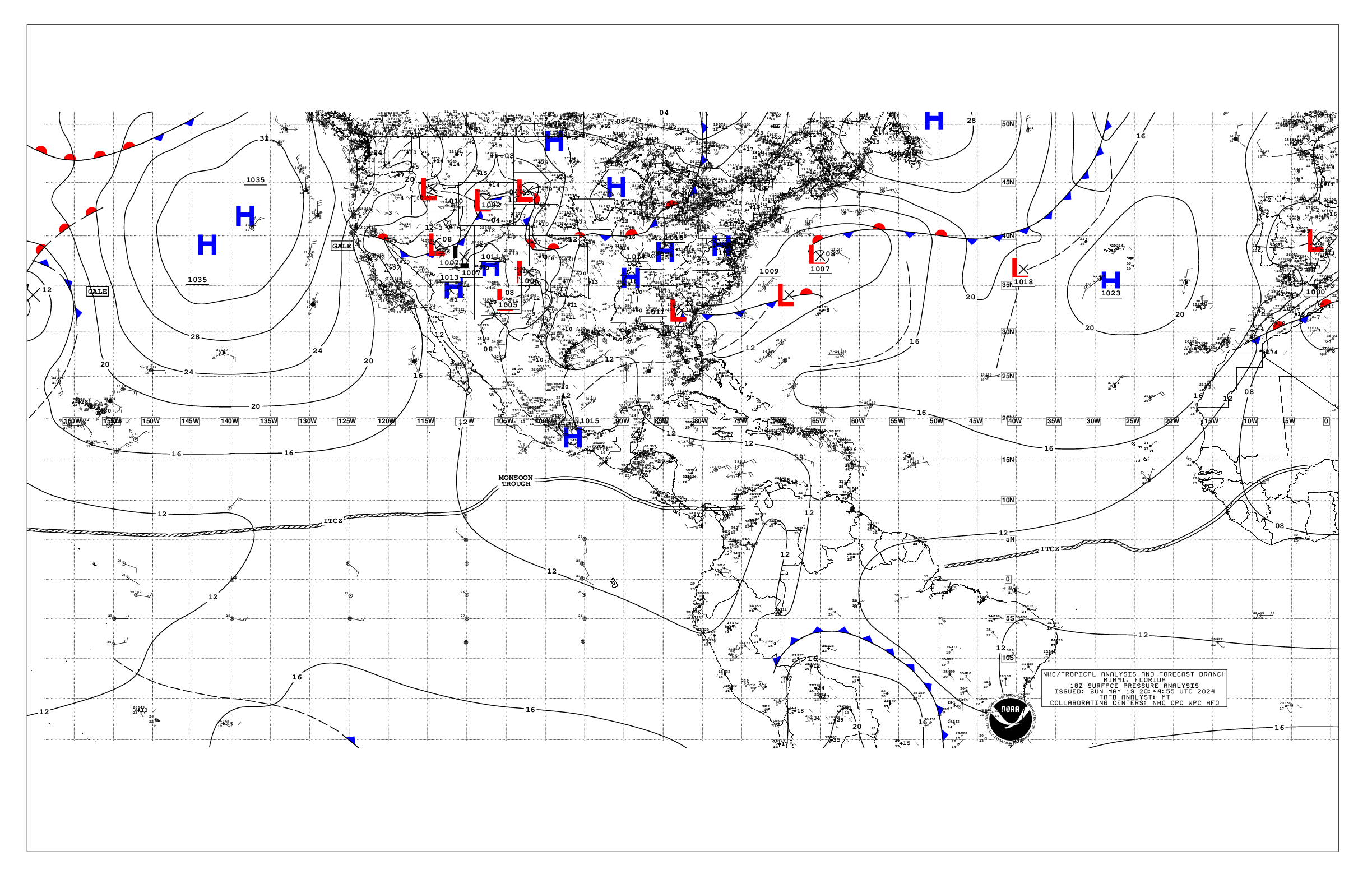
Based on 1800 UTC surface analysis and satellite imagery through
2100 UTC.
...SPECIAL FEATURES...
Heavy Rainfall in Hispaniola, Jamaica, and Eastern Cuba:
A persistent upper-level trough over the western Caribbean will
sustain divergent flow across the area through Friday. This will
support the generation of strong thunderstorms capable of
producing dangerous lightning, heavy rain, and gusty winds through
Friday. The greatest risk for large accumulations of rainfall is
from Tuesday through Friday. The heavy rain may lead to flash
flooding and mudslides. Flooding is also possible in areas of
Hispaniola where the ground remains saturated from recent heavy
rain events. Please refer to products from your local weather
service for more information.
...TROPICAL WAVES...
The axis of an Atlantic tropical wave is near 17W from 11N
southward, moving west at 10 kt. Scattered moderate convection is
from 03N to 09N between 14W and 21W.
The axis of an Atlantic tropical wave is near 30W from 09N
southward, moving west at 10-15 kt. Scattered showers are in the
vicinity of this tropical wave.
The axis of an Atlantic tropical wave is near 47W from 12N
southward, moving west at 15-20 kt. Scattered moderate convection
is noted from 04N to 10N between 40W and 50W.
The axis of a Caribbean tropical wave is near 63W, from 17N
southward, moving west at 10-15 kt. Scattered moderate convection
is in the NE Caribbean and Leeward Islands from 12N to 18N
between 60W and 65W.
The axis of a western Caribbean tropical wave is near 81W/82W
from 20N southward, moving west at around 5 kt. Scattered showers
are in the vicinity of the wave axis.
...MONSOON TROUGH/ITCZ...
The monsoon trough enters the Atlantic near 12N17W to 07N20W.
The ITCZ continues from 07N20W to 05N27W, from 05N32W to 05N42W,
and from 06N49W to 10N56W. Aside from convection mentioned in the
tropical waves section, scattered moderate convection is from 05N
to 11N between 50W and 58W.
GULF OF MEXICO...
High pressure ridging prevails across the Gulf of Mexico. Gentle
to moderate SE winds are west of 90W, with light to gentle east
of 90W. Seas are in the 4-5 ft range W of 90W, and 2-3 ft E of
90W.
For the forecast, the ridge will dominate the Gulf waters the
next several days, supporting generally moderate to fresh E to SE
winds in the western Gulf and gentle to moderate winds E of 90W,
except for locally strong winds pulsing near the northern and
western portions of the Yucatan peninsula in the evenings. Hazy
conditions due to agricultural fires over Central America and
Mexico will continue for the next couple of days reducing
visibility to 2-4 nm mainly over the western half of the Gulf.
CARIBBEAN SEA...
Please see the SPECIAL FEATURES section above for information on
a heavy rainfall event.
A surface trough near the Windward Passage is producing scattered
showers and isolated thunderstorms across eastern Cuba, the
Windward Passage, Jamaica, and Hispaniola. Moderate to fresh
trades are in the central Caribbean, with seas of 6-7 ft.
Moderate to locally fresh trades are present in the eastern
Caribbean with seas of 4-6 ft. Light to gentle winds are in the
NW Caribbean, with 3-6 ft seas.
For the forecast, fresh to strong trade winds will prevail across
the central Caribbean through early Mon, with seas to around 8
ft. Fresh to strong winds are also expected over portions of the
western basin just over southern Jamaica adjacent waters as a
tropical wave moves across the region through this evening.
ATLANTIC OCEAN...
A cold front extends from 31N50W, transitioning to a stationary
front near 24N67W, and then continuing to the southern Bahamas
adjacent waters. Scattered moderate convection is in the vicinity
of this boundary. Fresh to locally strong winds are within 60 nm N
of the front between 60W and 78W. Gentle to moderate winds are
elsewhere N of the front. Seas W of the front are in the 4-7 ft
range. The remainder of the waters E of the front are dominated by
high pressure, anchored by a 1022 mb high pressure centered near
27N39W. Light to gentle winds are in the vicinity of the high
center, with gentle to moderate winds elsewhere N of 20N. Moderate
winds prevail S of 20N. Seas east of the front are in the 3-6 ft
range.
For the forecast W of 55W, the front will become stationary along
25N this evening and weaken into a surface trough by Mon evening.
Energy associated with a convectively active tropical wave,
currently over the W Caribbean will lift NNE and merge with this
trough by Tue. Afterwards, the trough will drift eastward and move
to the central subtropical Atlantic waters Thu into Fri. Fresh SW
winds are forecast ahead of this trough as it crosses the north-
central and then eastern offshore waters.
$$
AL


