000
AXNT20 KNHC 062315
TWDAT
Tropical Weather Discussion
NWS National Hurricane Center Miami FL
0005 UTC Tue May 7 2024
Tropical Weather Discussion for North America, Central America
Gulf of Mexico, Caribbean Sea, northern sections of South
America, and Atlantic Ocean to the African coast from the
Equator to 31N. The following information is based on satellite
imagery, weather observations, radar and meteorological analysis.
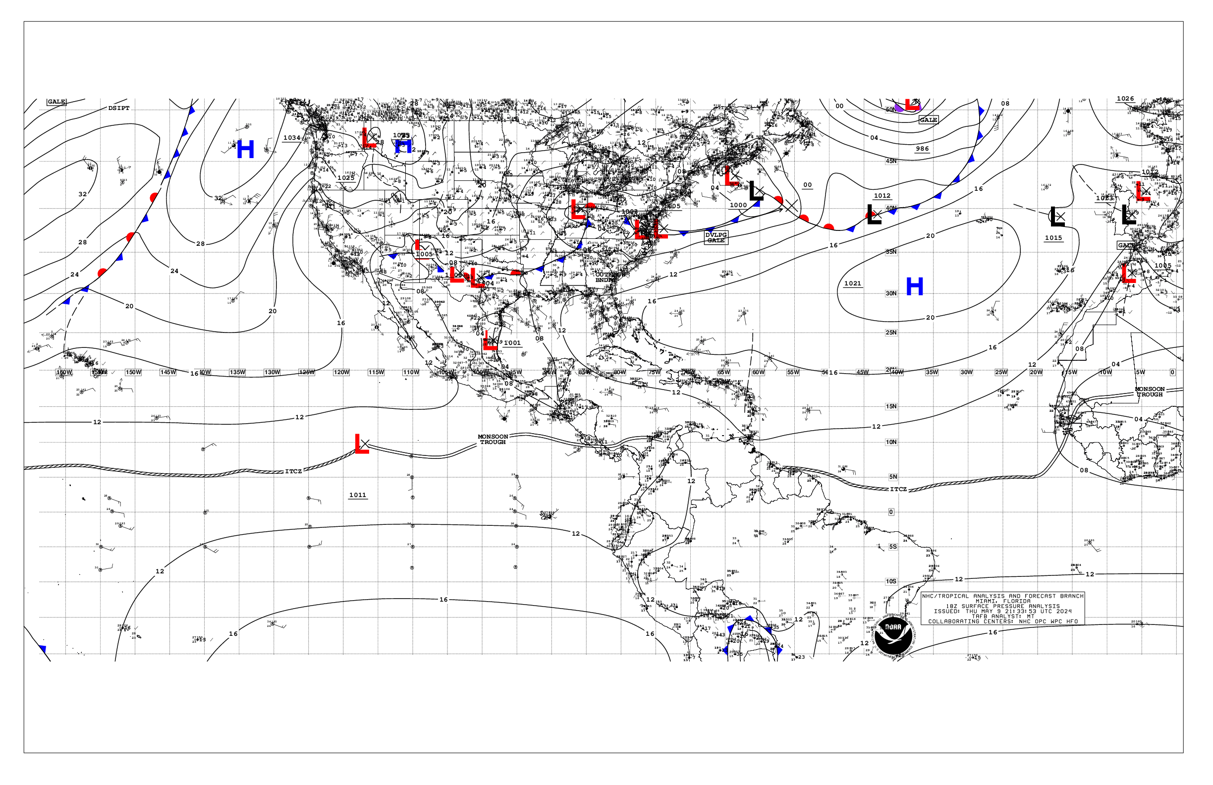
Based on 1800 UTC surface analysis and satellite imagery through
2220 UTC.
...MONSOON TROUGH/ITCZ...
The monsoon trough remains mainly inland over Africa, but does
extend offshore of Guinea-Bissau to 10N17.5W. The ITCZ extends
from 10N17.5W to 02.5N30W and to 01.5N50W. Scattered moderate to
strong convection is observed south of 06.5N between 03W and 23W,
and south of 05N between 23W and 50W.
...GULF OF MEXICO...
High pressure centered over the western Atlantic, northeast of
Bermuda, extends a ridge southwestward into the NW Gulf of
Mexico. Moderate to locally fresh NE to E winds are occurring
along the northern coast of the Yucatan, while moderate to
locally fresh southeasterly winds are found across all but the NE
portions of the Gulf, while moderate to fresh easterly winds
prevail in the Straits of Florida. Seas are 4 to 7 ft across the
basin, highest west central portions, except 2 to 3 across the NE
part.
Haze due to agricultural fires in southeastern Mexico is evident
in the SW and west-central Gulf.
For the forecast, low pressure extending from north-central
Mexico into the southern U.S. plains will continue to draw in
mainly fresh SE winds across much of the Gulf into Thu night.
Locally strong winds will pulse nightly Tue through late week off
the northern and western Yucatan Peninsula. Haze due to
agricultural fires in southeastern Mexico is evident in the SW and
west-central Gulf and is expected to continue through morning.
Looking ahead, a weak cold front will move off the Texas coast
into the northwest Gulf Thu night, shift southeast, then slow down
and weaken further as it reaches from Tampa to Tampico by late
Sat.
...CARIBBEAN SEA...
A persistent upper level trough extends from the western Atlantic
across Cuba and into the NW Caribbean, and continues to enhance
the development of showers and thunderstorms across the Greater
Antilles and surrounding Atlantic waters S of 23N. The trough
will gradually weaken and move farther northeast of the area, but
atmospheric conditions will remain favorable for convection
capable of producing gusty winds and frequent lightning early this
week. Locally heavy rainfall continues to bring a threat of
flooding in the islands. See local weather advisories for more
information.
High pressure centered over the western Atlantic northeast of
Bermuda is supporting gentle to moderate easterly winds in the
central and eastern portions of the basin, becoming moderate to
locally fresh SE winds across NW portions, including the Gulf of
Honduras. Seas are 3-4 ft except 4 to 6 ft across south central
portions. Elsewhere, light to gentle winds and slight seas
prevail.
For the forecast, High pressure centered over the western Atlantic
will support moderate to locally fresh trade winds over the
south-central Caribbean through mid week. The high pressure will
shift eastward later in the week, shifting the focus of fresh
winds more to the southeast Caribbean. Meanwhile, expect pulses
of fresh to strong E winds mainly at night across the Gulf of
Honduras starting Wed night, between the high pressure and lower
pressure over the western Gulf. Gentle to moderate winds and
moderate seas will persist elsewhere.
...ATLANTIC OCEAN...
A 1023 mb high pressure is centered northeast of Bermuda near
36N63W, and dominates the SW North Atlantic west of 55W. Moderate
to locally fresh easterly winds are noted south of the ridge,
between 24N and a shear line extending east to west along 19N, and
W of 60W. Seas in this zone are 4-6 ft. Elsewhere west of 55W,
moderate or weaker winds and moderate seas are prevalent.
Scattered moderate isolated strong afternoon convection occurring
across the Greater Antilles extends northeastward across the
adjacent waters to 23N, between 60W and 72W, while weak to
moderate convection is noted within 120 nm N of the shearline
along 19N.
Farther east, a cold front extends from the eastern semicircle of
a large low pressure system across the north-central Atlantic,
through 31N31W to 19.5N50W, where it transitions to the shearline
described above. Moderate to fresh southerly winds are evident
within 180 nm ahead of the front north of 25N. Seas in these
waters are 5-7 ft. Behind the front to 55W and north of 26N,
moderate to fresh NW to W winds and seas of 5-8 ft in northerly
swell prevail, increasing to 9 ft along 31N.
The remainder of the central and eastern Atlantic is dominated by
a weak high pressure centered near Madeira. The pressure gradient
between the ridge and lower pressures in NW Africa support fresh
to locally strong northerly winds north of 21N and east of 20W,
with the strongest winds occurring offshore southern Morocco. Seas
are 5-8 ft in these waters. Elsewhere in the tropical Atlantic,
moderate or weaker winds and moderate seas are evident.
For the forecast west of 55W, high pressure northeast of Bermuda
will support moderate to fresh E winds south of 23N through
tonight. Winds will then diminish as the ridge shifts southward
to 28N through mid week. Meanwhile, large N swell associated with
low pressure well NE of the region over the north-central
Atlantic will move through the waters north of 27N and east of 60W
into Tue night. Looking ahead, expect moderate to fresh SW winds
off northeast Florida starting Wed night as the high pressure
shifts southeast ahead of a cold front moving off the Carolinas.
$$
Stripling