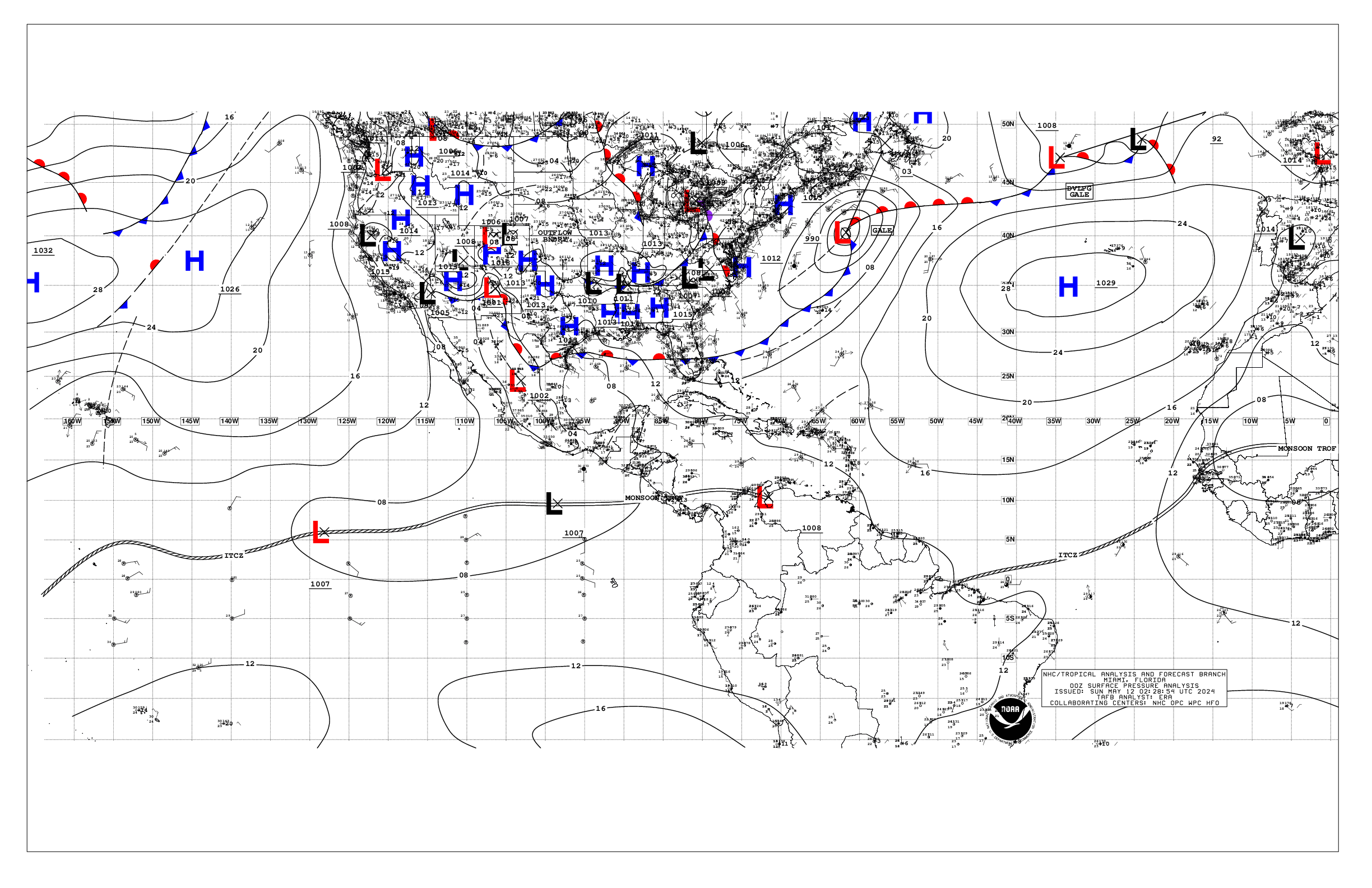
404
AXNT20 KNHC 130519
TWDAT

Tropical Weather Discussion
NWS National Hurricane Center Miami FL
0605 UTC Mon May 13 2024

Tropical Weather Discussion for North America, Central America
Gulf of Mexico, Caribbean Sea, northern sections of South
America, and Atlantic Ocean to the African coast from the
Equator to 31N. The following information is based on satellite
imagery, weather observations, radar and meteorological analysis.

Based on 0000 UTC surface analysis and satellite imagery through
0500 UTC.

...MONSOON TROUGH/ITCZ...

The monsoon trough extends from 16N17W to 05N26W. The ITCZ continues
from 05N26W to 02N50W. Scattered moderate convection is noted south
of 07N between 18W-35W.

Weak high pressure dominates the Gulf of Mexico. Scattered showers
and isolated thunderstorms are affecting the nearshore waters of
the northern Gulf. Fresh to strong easterly winds are found off
northern Yucatan, while gentle to moderate E-SE winds prevail
elsewhere west of 86W. Seas in the area described are 3-5 ft. In
the rest of the Gulf, light to gentle winds and slight seas are
prevalent.

For the forecast, high pressure will prevail across the basin. An
inverted trough may develop over the western Gulf early this week
where it may linger through at least mid-week. Moderate to fresh
return flow will dominate the basin, pulsing to strong near the
Yucatan Peninsula and Yucatan Channel. Meanwhile, haze due to
agricultural fires in Mexico continues across most of the western
Gulf and Bay of Campeche.

...CARIBBEAN SEA...

A weak pressure gradient prevails across the basin, sustaining
moderate easterly trade winds over most of the basin. The
exception is the Gulf of Honduras, where strong to near gale E-SE
winds are currently pulsing. Seas are slight to moderate across
the basin, with peak seas to 8 ft in the Gulf of Honduras.

For the forecast, high pressure over the central Atlantic will
continue to support strong to near gale E to SE winds near the
Gulf of Honduras, fresh to locally strong winds in the south-central
basin, and gentle to moderate winds elsewhere tonight. The
pressure gradient will tighten early this week, with fresh to
strong trade winds expected in the S-central and in the
northwestern Caribbean, and moderate to fresh trade winds
elsewhere. Seas will build next week as a result of the increasing
winds. Meanwhile, haze due to agricultural fires in Central
America continues across some areas of the northwestern Caribbean.

...ATLANTIC OCEAN...

A weak cold front extends from 31N63W to a 1012 mb low pressure in
the NW Bahamas. A pre-frontal trough is analyzed from 26N63W to
23N68W. Scattered moderate convection is noted north of 23N and
between 53W-63W. Moderate to fresh winds are noted near the front
mainly north of 28N and between 58W and 68W. Seas in these waters
are 4-6 ft. Light to gentle winds and slight to moderate seas
prevail elsewhere west of 50W, while moderate to fresh easterly
winds prevail east of 50W.

The remainder of the tropical Atlantic is dominated by a broad
1031 mb high pressure system centered to the west of the Azores.
The pressure gradient between this ridge and relatively lower
pressures in northwest Africa result in fresh to strong northerly
winds north of 15N and east of 22W. Seas in the area described
are in the 8 to 10 ft range. Elsewhere, moderate or weaker winds
and moderate seas are prevalent.

For the forecast W of 55W, the aforementioned front will weaken
as it reaches from near 31N59W the Central Bahamas by early Mon,
then dissipating from near 27N55W to 22N65W by early Tue. High
pressure will build in its wake. Fresh to strong southerly winds
and building seas are forecast offshore N Florida by Tue ahead of
another possible cold front. That front may reach from near 31N76W
to 27N80W by early Thu, weakening and stalling from 31N69W to near
Fort Pierce, Florida by early Fri.

$$
ERA
Alternate Formats
About Alternates -
E-Mail Advisories -
RSS Feeds
Cyclone Forecasts
Latest Advisory -
Past Advisories -
About Advisories
Marine Forecasts
Latest Products -
About Marine Products
Tools & Data
Satellite Imagery -
US Weather Radar -
Aircraft Recon -
Local Data Archive -
Forecast Verification -
Deadliest/Costliest/Most Intense
Learn About Hurricanes
Storm Names
Wind Scale -
Prepare -
Climatology -
NHC Glossary -
NHC Acronyms -
Frequently Asked Questions -
AOML Hurricane-Research Division
About Us
About NHC -
Mission/Vision -
Other NCEP Centers -
NHC Staff -
Visitor Information -
NHC Library
NOAA/
National Weather Service
National Centers for Environmental Prediction
National Hurricane Center
11691 SW 17th Street
Miami, Florida, 33165-2149 USA
nhcwebmaster@noaa.gov
Disclaimer
Privacy Policy
Credits
About Us
Glossary
Career Opportunities
Page last modified: Monday, 13-May-2024 05:27:12 UTC