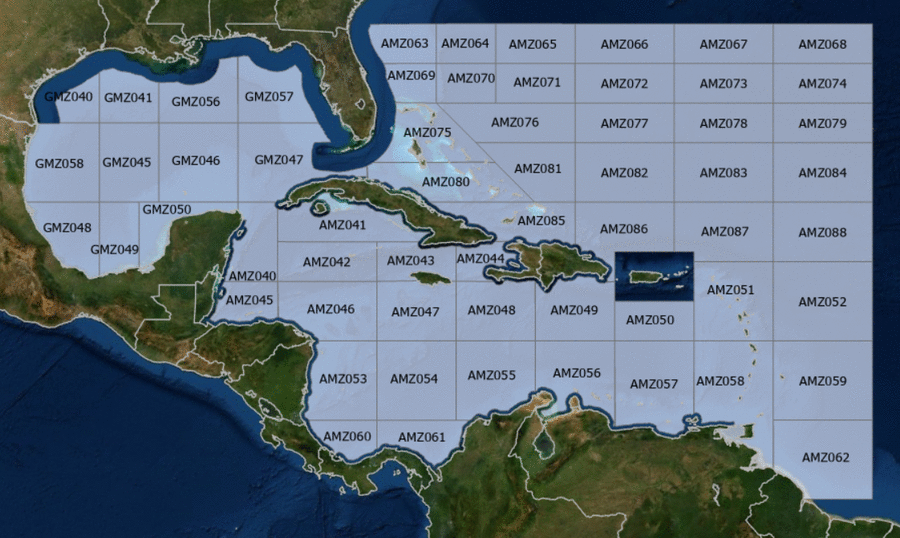
Hover to view popup zone forecast; click a zone to view related text forecast below. Show All Text Below
000
FZNT23 KNHC 191502
OFFNT3

Offshore Waters Forecast for the Caribbean Sea and Tropical
N Atlantic
NWS National Hurricane Center Miami, FL
1102 AM EDT Sun May 19 2024

Offshore Waters Forecast for Caribbean Sea, and the Tropical N
Atlantic from 07N to 19N W of 55W.

Seas given as significant wave height, which is the average
height of the highest 1/3 of the waves. Individual waves may be
more than twice the significant wave height.
AMZ001-200315-
Synopsis for Caribbean Sea, and Tropical N Atlantic from 07N to
19N W of 55W
1102 AM EDT Sun May 19 2024

.SYNOPSIS...A weak and narrow Atlantic ridge extends westward
along 24N/25N and into the NW Bahamas. The associated pressure
gradient between the ridge and lower pressure over SE Mexico is
supporting fresh to strong E to SE winds across the Gulf of
Honduras, and fresh to locally strong E winds in the south-
central Caribbean. Winds in the Gulf of Honduras will become
moderate to fresh today through Mon. Fresh to strong winds will
pulse at night in the Gulf of Venezuela and offshore Colombia
through early Mon then shift eastward to offshore of NW
Venezuela through Tue night. A vigorous middle to upper-level
trough will dig southward across the western Caribbean Mon night
through Thu, and support very active weather over the central
portions E of 80W Tue through Thu night. Smoke due to
agricultural fires in Central America continues across the Gulf of
Honduras and areas of the northwestern Caribbean.
AMZ040-200315-
Caribbean N of 18N W of 85W including Yucatan Basin-
1102 AM EDT Sun May 19 2024

.TODAY...SE winds 15 to 20 kt. Seas 6 to 8 ft in SE swell.
.TONIGHT...E to SE winds 10 to 15 kt. Seas 4 to 6 ft.
.MON...SE winds 10 to 15 kt. Seas 4 to 6 ft.
.MON NIGHT...E to SE winds 10 to 15 kt. Seas 4 to 6 ft.
.TUE...E to SE winds 10 to 15 kt. Seas 4 to 6 ft.
.TUE NIGHT...E to SE winds 10 to 15 kt. Seas 4 to 6 ft.
.WED...E to SE winds 10 to 15 kt. Seas 4 to 6 ft.
.WED NIGHT...E to SE winds 10 to 15 kt. Seas 4 to 6 ft.
.THU...E to SE winds 10 to 15 kt. Seas 4 to 6 ft.
.THU NIGHT...E to SE winds 10 to 15 kt. Seas 4 to 6 ft.
Forecaster Aguirre
AMZ041-200315-
Caribbean N of 20N E of 85W-
1102 AM EDT Sun May 19 2024

.TODAY...W of 81W, SE winds 10 to 15 kt. E of 81W, variable winds
less than 5 kt, becoming SE 10 kt in the afternoon. Seas 3 to
5 ft in SE to S swell.
.TONIGHT...SE winds 10 kt W of 81W, and variable less than 5 kt E
of 81W. Seas 3 to 5 ft in SE to S swell.
.MON...SE winds 10 kt W of 81W, and variable less than 5 kt E of
81W. Seas 3 to 4 ft.
.MON NIGHT...W of 81W, E winds 10 kt late. Variable
winds less than 5 kt in the evening. E of 81W, variable less than
5 kt. Seas 2 to 3 ft.
.TUE...W of 81W, E to SE winds 10 kt. E of 81W, variable winds
less than 5 kt, becoming SE 10 kt in the afternoon. Seas 2 to 3
ft.
.TUE NIGHT...W of 81W, E winds 10 kt in the evening, becoming
variable less than 5 kt. E of 81W, E winds 10 kt. Seas 2 to 3 ft.
.WED...E winds 10 kt. Seas 3 to 5 ft in SE to S swell.
.WED NIGHT...E winds 10 to 15 kt. Seas 3 to 4 ft W of 81W, and 4
to 6 ft E of 81W.
.THU...E to SE winds 10 to 15 kt. Seas 4 to 6 ft.
.THU NIGHT...E winds 10 to 15 kt. Seas 3 to 5 ft.
Forecaster Aguirre
AMZ042-200315-
Caribbean from 18N to 20N between 80W and 85W including Cayman
Basin-
1102 AM EDT Sun May 19 2024

.TODAY...E to SE winds 10 to 15 kt. Seas 3 to 5 ft.
.TONIGHT...E to SE winds 10 to 15 kt. Seas 3 to 5 ft.
.MON...E to SE winds 10 to 15 kt. Seas 3 to 5 ft.
.MON NIGHT...E winds 10 to 15 kt. Seas 3 to 5 ft.
.TUE...E to SE winds 10 to 15 kt. Seas 3 to 5 ft.
.TUE NIGHT...E to SE winds 10 kt. Seas 3 to 4 ft.
.WED...E winds 10 kt. Seas 3 to 4 ft.
.WED NIGHT...E winds 10 to 15 kt. Seas 3 to 5 ft.
.THU...E winds 10 kt. Seas 3 to 5 ft.
.THU NIGHT...E winds 10 to 15 kt. Seas 3 to 5 ft.
Forecaster Aguirre
AMZ043-200315-
Caribbean from 18N to 20N between 76W and 80W-
1102 AM EDT Sun May 19 2024

.TODAY...E winds 10 kt. Seas 3 to 4 ft.
.TONIGHT...E winds 10 kt. Seas 3 to 4 ft.
.MON...E to SE winds 10 to 15 kt. Seas 3 to 5 ft.
.MON NIGHT...E winds 10 kt. Seas 4 to 6 ft in E to SE swell.
.TUE...E to SE winds 10 to 15 kt. Seas 4 to 6 ft.
.TUE NIGHT...E to SE winds 10 to 15 kt W of 78W, and E to SE
15 to 20 kt E of 78W. Seas 4 to 6 ft.
.WED...W of 78W, E to SE winds 10 to 15 kt. Seas 4 to 6 ft. E of
78W, E to SE winds 15 to 20 kt. Seas 6 to 8 ft.
.WED NIGHT...E winds 15 to 20 kt. Seas 6 to 8 ft in E to SE
swell.
.THU...E winds 10 to 15 kt. Seas 5 to 7 ft in E to SE swell.
.THU NIGHT...E to SE winds 10 to 15 kt. Seas 4 to 6 ft.
Forecaster Aguirre
AMZ044-200315-
Caribbean approaches to the Windward Passage-
1102 AM EDT Sun May 19 2024

.TODAY...In the Gulf of Gonave, SE to S winds 10 kt late in the
morning, becoming variable less than 5 kt. Elsewhere, SE winds
10 kt. Seas 3 to 4 ft.
.TONIGHT...In the Gulf of Gonave, NW to N winds 10 kt in the
evening, becoming variable less than 5 kt. Elsewhere, SE winds
10 kt, shifting to E late. Seas 3 to 5 ft in SE swell.
.MON...In the Gulf of Gonave, SE to S winds 10 kt in the morning,
becoming variable less than 5 kt. Elsewhere, SE winds 10 to
15 kt, shifting to S in the afternoon. Seas 3 to 5 ft in SE swell.
.MON NIGHT...In the Gulf of Gonave, variable winds less than
5 kt. Elsewhere, SW winds 10 to 15 kt, shifting to NE to E late.
Seas 4 to 6 ft.
.TUE...In the Gulf of Gonave, variable winds less than 5 kt. Seas
3 ft or less. Elsewhere, E winds 10 to 15 kt. Seas 4 to 6 ft.
.TUE NIGHT...In the Gulf of Gonave, variable winds less than
5 kt, becoming SE 10 kt late. Elsewhere, E to SE winds
15 to 20 kt. Seas 2 to 3 ft in the Gulf of Gonave, and 5 to 7 ft
elsewhere.
.WED...In the Gulf of Gonave, SE winds 10 to 15 kt. Seas 3 to 4
ft. Elsewhere, E to SE winds 15 to 20 kt. Seas 6 to 9 ft.
.WED NIGHT...E winds 10 to 15 kt. Seas 3 to 4 ft in the Gulf of
Gonave, and 6 to 9 ft elsewhere.
.THU...In the Gulf of Gonave, E to SE winds 10 kt in the morning,
becoming variable less than 5 kt. Elsewhere, E winds 10 to 15 kt.
Seas 3 ft or less in the Gulf of Gonave, and 5 to 7 ft elsewhere.
.THU NIGHT...In the Gulf of Gonave, variable winds less than
5 kt. Seas 2 to 3 ft in SE swell. Elsewhere, E winds 10 kt. Seas
4 to 6 ft.
Forecaster Aguirre
AMZ045-200315-
S of 18N W of 85W including Gulf of Honduras-
1102 AM EDT Sun May 19 2024

.TODAY...S to SW winds 10 to 15 kt S of 17N W of 86W, and E to SE
15 to 20 kt elsewhere. Seas 6 to 8 ft in E swell. Haze.
.TONIGHT...E winds 15 to 20 kt. Seas 5 to 7 ft.
.MON...E winds 15 to 20 kt. Seas 4 to 6 ft.
.MON NIGHT...E winds 10 to 15 kt. Seas 3 to 5 ft.
.TUE...E winds 10 to 15 kt. Seas 3 to 5 ft.
.TUE NIGHT...E winds 15 kt. Seas 3 to 5 ft.
.WED...E winds 10 to 15 kt. Seas 3 to 5 ft.
.WED NIGHT...E winds 15 kt. Seas 3 to 5 ft.
.THU...E winds 10 to 15 kt. Seas 3 to 5 ft.
.THU NIGHT...E winds 15 to 20 kt. Seas 4 to 6 ft.
Forecaster Aguirre
AMZ046-200315-
Caribbean from 15N to 18N between 80W and 85W-
1102 AM EDT Sun May 19 2024

.TODAY...E to SE winds 10 to 15 kt. Seas 4 to 6 ft.
.TONIGHT...E winds 10 to 15 kt. Seas 4 to 6 ft.
.MON...E winds 10 to 15 kt. Seas 4 to 6 ft.
.MON NIGHT...E winds 10 to 15 kt. Seas 4 to 6 ft.
.TUE...E winds 10 to 15 kt. Seas 3 to 5 ft W of 82W, and 4 to
6 ft E of 82W.
.TUE NIGHT...E winds 10 to 15 kt. Seas 3 to 4 ft W of 82W, and 4
to 6 ft E of 82W.
.WED...NE to E winds 10 to 15 kt. Seas 3 to 4 ft W of 82W, and 4
to 6 ft E of 82W.
.WED NIGHT...E winds 10 to 15 kt. Seas 3 to 4 ft W of 82W, and 3
to 5 ft E of 82W.
.THU...E winds 10 kt. Seas 2 to 3 ft W of 82W, and 3 to 5 ft E of
82W.
.THU NIGHT...E winds 10 to 15 kt. Seas 3 to 5 ft.
Forecaster Aguirre
AMZ047-200315-
Caribbean from 15N to 18N between 76W and 80W-
1102 AM EDT Sun May 19 2024

.TODAY...E winds 15 to 20 kt S of 17N, and E 10 to 15 kt N of
17N. Seas 4 to 6 ft.
.TONIGHT...E winds 10 to 15 kt. Seas 5 to 7 ft in E to SE swell.
.MON...E winds 15 to 20 kt S of 17N, and E 10 to 15 kt N of 17N.
Seas 5 to 7 ft in E to SE swell.
.MON NIGHT...E winds 15 to 20 kt S of 17N, and E 10 to 15 kt N of
17N. Seas 5 to 7 ft in E to SE swell.
.TUE...E winds 15 to 20 kt S of 17N, and E 10 to 15 kt N of 17N.
Seas 6 to 8 ft in E to SE swell.
.TUE NIGHT...Winds E winds 15 to 20 kt. Seas 6 to 8 ft in E to SE
swell.
.WED...E winds 15 to 20 kt. Seas 7 to 10 ft in E to SE swell.
.WED NIGHT...E to SE winds 10 to 15 kt S of 17N, and E 15 to
20 kt N of 17N. Seas 6 to 9 ft in E to SE swell.
.THU...E to SE winds 10 kt. Seas 5 to 7 ft in E to SE swell.
.THU NIGHT...E to SE winds 10 kt. Seas 3 to 5 ft.
Forecaster Aguirre
AMZ048-200315-
Caribbean from 15N to 18N between 72W and 76W-
1102 AM EDT Sun May 19 2024

.TODAY...E winds 15 to 20 kt. Seas 5 to 7 ft.
.TONIGHT...E winds 15 to 20 kt S of 17N, and E 10 to 15 kt N of
17N. Seas 5 to 7 ft.
.MON...E winds 15 to 20 kt. Seas 6 to 8 ft in E to SE swell.
.MON NIGHT...E winds 15 to 20 kt. Seas 6 to 8 ft in E to SE
swell.
.TUE...E winds 15 to 20 kt. Seas 6 to 8 ft in E to SE swell.
.TUE NIGHT...E to SE winds 15 to 20 kt. Seas 6 to 8 ft in E to SE
swell.
.WED...E winds 20 to 25 kt. Seas 7 to 10 ft in E to SE swell.
.WED NIGHT...E to SE winds 15 to 20 kt. Seas 6 to 9 ft in E to SE
swell.
.THU...SE winds 10 to 15 kt. Seas 5 to 7 ft in E to SE swell.
.THU NIGHT...E winds 10 kt. Seas 4 to 6 ft in E to SE swell.
Forecaster Aguirre
AMZ049-200315-
Caribbean N of 15N between 68W and 72W-
1102 AM EDT Sun May 19 2024

.TODAY...E winds 15 to 20 kt W of 70W, and E to SE 10 to 15 kt E
of 70W. Seas 4 to 6 ft.
.TONIGHT...E winds 15 to 20 kt. Seas 5 to 7 ft in E to SE swell.
.MON...E to SE winds 15 to 20 kt. Seas 6 to 8 ft.
.MON NIGHT...E winds 15 to 20 kt. Seas 6 to 8 ft.
.TUE...E to SE winds 15 to 20 kt. Seas 6 to 8 ft in SE swell.
.TUE NIGHT...E winds 15 to 20 kt W of 70W, and E to SE 15 to
20 kt E of 70W. Seas 6 to 8 ft in SE swell.
.WED...E winds 15 to 20 kt W of 70W, and E 10 to 15 kt E of 70W.
Seas 6 to 8 ft.
.WED NIGHT...E to SE winds 15 to 20 kt. Seas 5 to 7 ft.
.THU...SE winds 15 to 20 kt. Seas 5 to 7 ft.
.THU NIGHT...E to SE winds 10 to 15 kt. Seas 4 to 6 ft.
Forecaster Aguirre
AMZ050-200315-
Caribbean N of 15N between 64W and 68W-
1102 AM EDT Sun May 19 2024

.TODAY...E to SE winds 10 to 15 kt. Seas 3 to 5 ft.
.TONIGHT...E to SE winds 15 to 20 kt W of 66W, and E to SE 10 to
15 kt E of 66W. Seas 4 to 6 ft.
.MON...E to SE winds 15 kt. Seas 4 to 6 ft.
.MON NIGHT...E to SE winds 15 to 20 kt W of 66W, and E to SE
10 to 15 kt E of 66W. Seas 4 to 6 ft.
.TUE...E to SE winds 15 to 20 kt. Seas 4 to 6 ft.
.TUE NIGHT...E to SE winds 15 kt. Seas 4 to 6 ft.
.WED...E to SE winds 10 to 15 kt. Seas 4 to 6 ft.
.WED NIGHT...E winds 15 to 20 kt W of 66W, and E 10 to 15 kt E of
66W. Seas 4 to 6 ft.
.THU...E to SE winds 15 to 20 kt. Seas 5 to 7 ft.
.THU NIGHT...E to SE winds 15 to 20 kt. Seas 4 to 6 ft.
Forecaster Aguirre
AMZ051-200315-
Offshore Waters Leeward Islands-
1102 AM EDT Sun May 19 2024

.TODAY...E to SE winds 10 kt. Seas 3 to 5 ft.
.TONIGHT...E to SE winds 10 to 15 kt. Seas 3 to 5 ft.
.MON...E to SE winds 10 to 15 kt. Seas 3 to 5 ft.
.MON NIGHT...E to SE winds 10 to 15 kt. Seas 3 to 5 ft.
.TUE...E to SE winds 10 to 15 kt. Seas 3 to 5 ft.
.TUE NIGHT...E to SE winds 15 kt. Seas 4 to 6 ft.
.WED...E to SE winds 15 to 20 kt. Seas 4 to 6 ft.
.WED NIGHT...E winds 15 kt. Seas 4 to 6 ft.
.THU...E to SE winds 15 to 20 kt. Seas 4 to 6 ft.
.THU NIGHT...E to SE winds 15 kt. Seas 4 to 6 ft.
Forecaster Aguirre
AMZ052-200315-
Tropical N Atlantic from 15N to 19N between 55W and 60W-
1102 AM EDT Sun May 19 2024

.TODAY...E winds 10 to 15 kt. Seas 3 to 5 ft.
.TONIGHT...E winds 10 to 15 kt. Seas 3 to 5 ft.
.MON...E winds 10 to 15 kt. Seas 3 to 5 ft.
.MON NIGHT...E winds 10 to 15 kt. Seas 3 to 5 ft.
.TUE...E to SE winds 15 kt. Seas 4 to 6 ft.
.TUE NIGHT...E winds 15 to 20 kt. Seas 4 to 6 ft.
.WED...E winds 15 to 20 kt. Seas 4 to 6 ft.
.WED NIGHT...E winds 15 to 20 kt. Seas 4 to 6 ft.
.THU...E winds 15 kt. Seas 4 to 6 ft.
.THU NIGHT...E winds 15 kt. Seas 4 to 6 ft.
Forecaster Aguirre
AMZ053-200315-
W Central Caribbean from 11N to 15N W of 80W-
1102 AM EDT Sun May 19 2024

.TODAY...NE to E winds 10 to 15 kt. Seas 5 to 7 ft in E swell.
.TONIGHT...NE to E winds 15 kt. Seas 5 to 7 ft in E swell.
.MON...NE to E winds 10 to 15 kt. Seas 5 to 7 ft in E swell.
.MON NIGHT...NE to E winds 10 to 15 kt. Seas 4 to 6 ft. Scattered
showers and isolated thunderstorms.
.TUE...NE winds 10 to 15 kt. Seas 4 to 6 ft.
.TUE NIGHT...NE winds 10 to 15 kt. Seas 4 to 6 ft.
.WED...N to NE winds 10 kt. Seas 4 to 6 ft in E swell.
.WED NIGHT...NE winds 10 kt. Seas 3 to 5 ft in E swell.
.THU...Variable winds less than 5 kt. Seas 2 to 4 ft in E swell.
.THU NIGHT...In the reefs, E winds 10 kt. In the open waters, NE
winds 10 kt in the evening, becoming variable less than 5 kt.
Seas 2 to 4 ft in E swell.
Forecaster Aguirre
AMZ054-200315-
Caribbean from 11N to 15N between 76W and 80W-
1102 AM EDT Sun May 19 2024

.TODAY...NE to E winds 15 to 20 kt. Seas 6 to 9 ft in E swell.
.TONIGHT...NE to E winds 15 to 20 kt. Seas 6 to 8 ft in E swell.
.MON...NE to E winds 15 to 20 kt. Seas 6 to 8 ft in E swell.
.MON NIGHT...NE to E winds 10 to 15 kt W of 78W, and E 15 to
20 kt E of 78W. Seas 6 to 8 ft in NE to E swell. Scattered
showers and isolated thunderstorms.
.TUE...E winds 10 to 15 kt W of 78W, and E to SE 15 to 20 kt E of
78W. Seas 6 to 8 ft.
.TUE NIGHT...SE winds 10 to 15 kt. Seas 5 to 7 ft in NE to E
swell.
.WED...S winds 10 kt. Seas 5 to 7 ft in NE to E swell.
.WED NIGHT...SE winds 10 kt. Seas 5 to 7 ft in NE to E swell.
.THU...W of 78W, SE winds 10 kt in the morning, becoming variable
less than 5 kt. E of 78W, SE to S winds 10 kt. Seas 4 to 6 ft in
NE to E swell.
.THU NIGHT...Variable winds less than 5 kt. Seas 3 to 5 ft in NE
to E swell.
Forecaster Aguirre
AMZ055-200315-
Caribbean from 11N to 15N between 72W and 76W including Colombia
Basin-
1102 AM EDT Sun May 19 2024

.TODAY...NE to E winds 20 kt. Seas 6 to 8 ft in E swell.
.TONIGHT...NE to E winds 20 to 25 kt. Seas 6 to 9 ft in E swell.
.MON...E winds 20 to 25 kt. Seas 6 to 9 ft in E swell.
.MON NIGHT...E winds 15 to 20 kt. Seas 6 to 9 ft in NE to E
swell. Scattered showers and isolated thunderstorms.
.TUE...SE winds 15 to 20 kt S of 13N, and E 15 to 20 kt N of 13N.
Seas 6 to 9 ft in NE to E swell.
.TUE NIGHT...S winds 10 kt S of 13N, and E to SE 15 to 20 kt N of
13N. Seas 6 to 8 ft in NE to E swell.
.WED...S of 13N, SE to S winds 10 kt, shifting to E in the
afternoon. N of 13N, SE winds 15 to 20 kt. Seas 6 to 8 ft in NE
to E swell.
.WED NIGHT...E winds 10 to 15 kt. Seas 6 to 8 ft in NE to E
swell.
.THU...E to SE winds 10 to 15 kt. Seas 4 to 6 ft.
.THU NIGHT...NE to E winds 10 kt. Seas 4 to 6 ft in NE to E
swell.
Forecaster Aguirre
AMZ056-200315-
Caribbean S of 15N between 68W and 72W including Gulf of
Venezuela-
1102 AM EDT Sun May 19 2024

.TODAY...E winds 20 kt. Seas 5 to 7 ft.
.TONIGHT...E winds 20 to 25 kt. Seas 6 to 8 ft.
.MON...E winds 20 to 25 kt. Seas 6 to 8 ft.
.MON NIGHT...E winds 20 to 25 kt. Seas 6 to 9 ft in E swell.
.TUE...E to SE winds 15 to 20 kt S of 13N, and E 20 to 25 kt N of
13N. Seas 6 to 8 ft.
.TUE NIGHT...E winds 15 to 20 kt. Seas 6 to 8 ft in E swell.
.WED...E winds 15 to 20 kt. Seas 6 to 8 ft in E swell.
.WED NIGHT...E winds 15 to 20 kt. Seas 5 to 7 ft.
.THU...E winds 15 to 20 kt S of 13N, and E to SE 15 to 20 kt N of
13N. Seas 5 to 7 ft.
.THU NIGHT...E winds 10 to 15 kt. Seas 4 to 6 ft.
Forecaster Aguirre
AMZ057-200315-
Caribbean S of 15N between 64W and 68W including Venezuela Basin-
1102 AM EDT Sun May 19 2024

.TODAY...E winds 15 to 20 kt. Seas 4 to 6 ft.
.TONIGHT...E winds 15 to 20 kt. Seas 5 to 7 ft.
.MON...E to SE winds 15 to 20 kt. Seas 5 to 7 ft.
.MON NIGHT...E winds 15 to 20 kt. Seas 5 to 7 ft.
.TUE...E winds 15 to 20 kt. Seas 5 to 7 ft.
.TUE NIGHT...E winds 15 to 20 kt. Seas 4 to 6 ft.
.WED...E to SE winds 15 to 20 kt. Seas 5 to 7 ft.
.WED NIGHT...E winds 15 to 20 kt. Seas 5 to 7 ft.
.THU...E to SE winds 15 to 20 kt. Seas 4 to 6 ft.
.THU NIGHT...E winds 15 to 20 kt. Seas 4 to 6 ft.
Forecaster Aguirre
AMZ058-200315-
Offshore Waters Windward Islands including Trinidad and Tobago-
1102 AM EDT Sun May 19 2024

.TODAY...E to SE winds 10 to 15 kt. Seas 4 to 6 ft.
.TONIGHT...E to SE winds 15 to 20 kt in the Caribbean, and E
10 to 15 kt in the Atlc. Seas 4 to 6 ft.
.MON...E winds 10 to 15 kt. Seas 3 to 5 ft.
.MON NIGHT...E winds 15 to 20 kt in the Caribbean, and E 10 to
15 kt in the Atlc. Seas 3 to 5 ft.
.TUE...E winds 10 to 15 kt. Seas 3 to 5 ft.
.TUE NIGHT...E to SE winds 15 to 20 kt in the Caribbean, and E
10 to 15 kt in the Atlc. Seas 4 to 6 ft.
.WED...E to SE winds 15 to 20 kt in the Caribbean, and E 10 to
15 kt in the Atlc. Seas 4 to 6 ft.
.WED NIGHT...E winds 15 to 20 kt in the Caribbean, and E 10 to
15 kt in the Atlc. Seas 4 to 6 ft.
.THU...E winds 10 to 15 kt. Seas 4 to 6 ft.
.THU NIGHT...E winds 10 to 15 kt. Seas 4 to 6 ft.
Forecaster Aguirre
AMZ059-200315-
Tropical N Atlantic from 11N and 15N between 55W and 60W-
1102 AM EDT Sun May 19 2024

.TODAY...E winds 15 kt. Seas 4 to 6 ft.
.TONIGHT...E winds 15 kt. Seas 4 to 6 ft.
.MON...E winds 10 to 15 kt. Seas 3 to 5 ft.
.MON NIGHT...E winds 15 kt. Seas 3 to 5 ft.
.TUE...E winds 15 kt. Seas 4 to 6 ft.
.TUE NIGHT...E winds 15 to 20 kt. Seas 5 to 7 ft.
.WED...E winds 15 to 20 kt. Seas 5 to 7 ft.
.WED NIGHT...E winds 15 to 20 kt. Seas 4 to 6 ft.
.THU...E winds 15 kt. Seas 4 to 6 ft.
.THU NIGHT...E winds 15 kt. Seas 4 to 6 ft.
Forecaster Aguirre
AMZ060-200315-
SW Caribbean S of 11N W of 80W-
1102 AM EDT Sun May 19 2024

.TODAY...Variable winds less than 5 kt S of 10N, and NE 10 to
15 kt N of 10N. Seas 4 to 6 ft. Scattered showers and thunderstorms.
.TONIGHT...N to NE winds 10 to 15 kt. Seas 4 to 6 ft. Scattered
showers and thunderstorms.
.MON...S of 10N, NW winds 10 kt. N of 10N, NE winds 10 kt in the
morning, becoming variable less than 5 kt. Seas 4 to 6 ft in NE
swell. Scattered showers and thunderstorms.
.MON NIGHT...S of 10N, W to NW winds 10 kt. N of 10N, variable
winds less than 5 kt, becoming N 10 kt late. Seas 3 to 5 ft in NE
swell. Scattered showers and thunderstorms.
.TUE...S of 10N, W to NW winds 10 kt. N of 10N, variable winds
less than 5 kt, becoming NW 10 kt in the afternoon. Seas 3 to
5 ft in NE swell.
.TUE NIGHT...NW winds 10 kt in the evening, becoming variable
less than 5 kt. Seas 3 to 4 ft.
.WED...W to NW winds 10 kt. Seas 3 to 4 ft.
.WED NIGHT...Variable winds less than 5 kt. Seas 3 to 4 ft in NE
swell.
.THU...Variable winds less than 5 kt. Seas 2 to 4 ft in NE swell.
.THU NIGHT...Variable winds less than 5 kt. Seas 2 to 4 ft in NE
swell.
Forecaster Aguirre
AMZ061-200315-
SW Caribbean S of 11N E of 80W including the approaches to the
Panama Canal-
1102 AM EDT Sun May 19 2024

.TODAY...S of 10N, variable winds less than 5 kt, becoming NW
10 kt in the afternoon. N of 10N, NE to E winds 10 to 15 kt. Seas
6 to 8 ft in NE swell. Isolated showers and thunderstorms.
.TONIGHT...NE winds 10 to 15 kt. Seas 5 to 7 ft in NE swell.
Scattered showers and isolated thunderstorms.
.MON...E winds 10 to 15 kt, shifting to SW in the afternoon. Seas
5 to 7 ft in NE swell. Scattered showers and isolated
thunderstorms.
.MON NIGHT...SW to W winds 10 kt. Seas 4 to 6 ft in NE swell.
Scattered thunderstorms.
.TUE...SW winds 10 kt. Seas 3 to 5 ft in NE swell.
.TUE NIGHT...S to SW winds 10 kt. Seas 3 to 4 ft.
.WED...S to SW winds 10 kt. Seas 3 to 4 ft.
.WED NIGHT...S of 10N, variable winds less than 5 kt, becoming S
10 kt late. N of 10N, variable winds less than 5 kt. Seas 3 to 4
ft in NE swell.
.THU...S of 10N, S winds 10 kt in the morning, becoming variable
less than 5 kt. N of 10N, variable winds less than 5 kt. Seas
2 to 3 ft.
.THU NIGHT...Variable winds less than 5 kt. Seas 2 to 3 ft  in NE
swell.
Forecaster Aguirre
AMZ062-200315-
Tropical N Atlantic from 7N and 11N between 55W and 60W-
1102 AM EDT Sun May 19 2024

.TODAY...E winds 10 to 15 kt. Seas 4 to 6 ft. Scattered showers
and isolated thunderstorms.
.TONIGHT...E winds 10 to 15 kt. Seas 4 to 6 ft. Scattered showers
and isolated thunderstorms.
.MON...E winds 10 to 15 kt. Seas 4 to 6 ft. Scattered showers and
isolated thunderstorms.
.MON NIGHT...E winds 10 to 15 kt. Seas 4 to 6 ft. Scattered
showers and isolated thunderstorms.
.TUE...E winds 10 to 15 kt. Seas 4 to 6 ft.
.TUE NIGHT...E winds 10 to 15 kt. Seas 4 to 6 ft.
.WED...E winds 15 kt. Seas 4 to 6 ft.
.WED NIGHT...E winds 15 kt. Seas 4 to 6 ft.
.THU...E winds 10 to 15 kt. Seas 4 to 6 ft.
.THU NIGHT...NE to E winds 10 to 15 kt. Seas 4 to 6 ft.
Forecaster Aguirre
639
FZNT25 KNHC 191422
OFFNT5

Offshore Waters Forecast for the SW N Atlantic including the
Bahamas
NWS National Hurricane Center Miami, FL
1022 AM EDT Sun May 19 2024

Offshore Waters Forecast for the SW N Atlantic from 19N to 31N W
of 55W including Bahamas.

Seas given as significant wave height, which is the average
height of the highest 1/3 of the waves. Individual waves may be
more than twice the significant wave height.
AMZ101-200230-
Synopsis for the SW N Atlantic including the Bahamas
1022 AM EDT Sun May 19 2024

.SYNOPSIS...A weak frontal trough extends from 31N55W
southwestward to 27N60W and to 26N67W, while a narrow high
pressure ridge extends E to W to the south of the trough along
24N/25N and into the NW Bahamas. The trough will shift eastward
through this afternoon as it weakens further, allowing the ridge
to build modestly into the region E of 72W Mon and Tue. Scattered
showers and thunderstorms will move from the NW waters southeastward
through this evening, ahead of an upper-level trough. Behind this
feature, a new front will sink southward into the waters offshore
of Georgia and NE Florida early Mon, and move southeastward and
stall from near 31N72W to SE Florida late Tue. A trough will
develop southeast of the weakening front and extend into the
central Bahamas early on Wed, and drift eastward through Thu
night. Low pressure is expected to form along the trough near
24N68W Thu evening and move NE.
AMZ063-200230-
Atlantic from 29N to 31N W of 77W-
1022 AM EDT Sun May 19 2024

.TODAY...W winds 10 to 15 kt. Seas 3 to 4 ft. Winds and seas
higher in and near scattered to numerous showers and
thunderstorms.
.TONIGHT...W of 79W, variable winds less than 5 kt, becoming NE
10 kt late. E of 79W, W to NW winds 10 to 15 kt. Seas
3 to 4 ft. Scattered showers and thunderstorms.
.MON...N to NE winds 10 to 15 kt. Seas 5 to 7 ft in N to NE
swell. Scattered showers and thunderstorms.
.MON NIGHT...NE winds 15 to 20 kt W of 79W, and NE 10 to 15 kt E
of 79W. Seas 5 to 7 ft in N to NE swell. Scattered showers and
isolated thunderstorms.
.TUE...NE winds 10 to 15 kt. Seas 4 to 6 ft.
.TUE NIGHT...NE to E winds 10 to 15 kt. Seas 3 to 5 ft.
.WED...NE winds 10 kt. Seas 3 to 5 ft.
.WED NIGHT...E winds 10 kt in the evening, becoming variable less
than 5 kt. Seas 3 to 4 ft.
.THU...Variable winds less than 5 kt. Seas 3 to 4 ft in NE to E
swell.
.THU NIGHT...W of 79W, SE to S winds 10 kt. E of 79W, variable
winds less than 5 kt, becoming SE to S 10 kt late. Seas 3 to 4
ft.
Forecaster Aguirre
AMZ064-200230-
Atlantic from 29N to 31N between 74W and 77W-
1022 AM EDT Sun May 19 2024

.TODAY...SW to W winds 10 to 15 kt. Seas 3 to 4 ft. Winds and seas
higher in and near scattered to numerous showers and thunderstorms.
.TONIGHT...W winds 10 to 15 kt. Seas 3 to 4 ft. Scattered showers
and thunderstorms.
.MON...W of 75W, NW winds 10 kt, shifting to N to NE in the
afternoon. E of 75W, W to NW winds 10 kt in the morning, becoming
variable less than 5 kt. Seas 3 to 5 ft. Scattered showers and
thunderstorms.
.MON NIGHT...NE winds 15 to 20 kt W of 75W, and N to NE 10 to
15 kt E of 75W. Seas 3 to 5 ft. Scattered showers and isolated
thunderstorms.
.TUE...NE winds 10 to 15 kt. Seas 3 to 5 ft.
.TUE NIGHT...NE winds 10 to 15 kt. Seas 3 to 5 ft.
.WED...NE winds 10 kt. Seas 3 to 5 ft.
.WED NIGHT...NE winds 10 kt in the evening, becoming variable
less than 5 kt. Seas 2 to 4 ft.
.THU...W of 75W, variable winds less than 5 kt, becoming NE 10 kt
in the afternoon. E of 75W, N to NE winds 10 kt. Seas 2 to 4 ft.
.THU NIGHT...Variable winds less than 5 kt. Seas 3 ft or less in
NE swell.
Forecaster Aguirre
AMZ065-200230-
Atlantic from 29N to 31N between 70W and 74W-
1022 AM EDT Sun May 19 2024

.TODAY...SW to W winds 10 to 15 kt. Seas 2 to 4 ft. Scattered
showers and thunderstorms i the afternoon.
.TONIGHT...SW to W winds 10 to 15 kt. Seas 2 to 4 ft. Scattered
showers and thunderstorms.
.MON...SW to W winds 10 to 15 kt. Seas 3 to 5 ft. Scattered
showers and thunderstorms.
.MON NIGHT...W of 72W, SW to W winds 10 kt, shifting to SE to S
late. E of 72W, SW winds 15 to 20 kt. Seas 3 to 5 ft in mixed
swell W of 72W, and 4 to 6 ft E of 72W. Scattered showers and
thunderstorms.
.TUE...E winds 10 kt. Seas 3 to 5 ft in mixed N and SE swell.
.TUE NIGHT...SE winds 10 kt. Seas 3 to 5 ft in N to NE swell.
.WED...N winds 10 kt W of 72W, and variable less than 5 kt E of
72W. Seas 3 to 5 ft in N to NE swell .
.WED NIGHT...W of 72W, N to NE winds 10 kt in the evening,
becoming variable less than 5 kt. E of 72W, variable winds less
than 5 kt. Seas 3 to 4 ft.
.THU...N to NE winds 10 kt W of 72W, and variable less than 5 kt
E of 72W. Seas 3 to 4 ft.
.THU NIGHT...Variable winds less than 5 kt. Seas 3 to 4 ft in NE
swell.
Forecaster Aguirre
AMZ066-200230-
Atlantic from 29N to 31N between 65W and 70W-
1022 AM EDT Sun May 19 2024

.TODAY...SW winds 10 to 15 kt. Seas 3 to 4 ft. Isolated showers
and thunderstorms.
.TONIGHT...SW winds 10 to 15 kt. Seas 3 to 4 ft. Scattered
showers and isolated thunderstorms.
.MON...SW to W winds 15 to 20 kt. Seas 3 to 5 ft. Scattered
showers and isolated thunderstorms.
.MON NIGHT...SW to W winds 10 to 15 kt. Seas 3 to 5 ft. Scattered
showers and isolated thunderstorms.
.TUE...S to SW winds 10 kt. Seas 3 to 4 ft.
.TUE NIGHT...S winds 10 kt. Seas 3 to 5 ft in N to NE swell.
.WED...S winds 10 kt. Seas 3 to 5 ft in N to NE swell.
.WED NIGHT...S winds 10 to 15 kt. Seas 3 to 4 ft.
.THU...S to SW winds 10 kt. Seas 3 to 4 ft.
.THU NIGHT...Variable winds less than 5 kt W of 67W, and S 10 kt
E of 67W. Seas 3 to 4 ft.
Forecaster Aguirre
AMZ067-200230-
Atlantic from 29N to 31N between 60W and 65W-
1022 AM EDT Sun May 19 2024

.TODAY...SW to W winds 10 to 15 kt. Seas 3 to 4 ft.
.TONIGHT...SW winds 10 to 15 kt. Seas 3 to 5 ft.
.MON...SW winds 15 to 20 kt. Seas 4 to 6 ft.
.MON NIGHT...SW to W winds 10 to 15 kt. Seas 3 to 5 ft.
.TUE...SW winds 10 to 15 kt. Seas 3 to 5 ft.
.TUE NIGHT...S to SW winds 10 kt. Seas 3 to 4 ft.
.WED...S to SW winds 10 kt. Seas 3 to 4 ft.
.WED NIGHT...W of 62W, S winds 10 kt. E of 62W, S winds 10 kt in
the evening, becoming variable less than 5 kt. Seas 3 to 4 ft.
.THU...S winds 10 kt. Seas 3 to 4 ft.
.THU NIGHT...S to SW winds 10 kt. Seas 3 to 4 ft.
Forecaster Aguirre
AMZ068-200230-
Atlantic from 29N to 31N between 55W and 60W-
1022 AM EDT Sun May 19 2024

.TODAY...SW to W winds 10 to 15 kt. Seas 3 to 4 ft. Scattered
showers and isolated thunderstorms.
.TONIGHT...W winds 10 kt. Seas 3 to 4 ft.
.MON...SW winds 10 to 15 kt. Seas 3 to 4 ft.
.MON NIGHT...SW winds 10 to 15 kt. Seas 3 to 5 ft.
.TUE...SW winds 10 to 15 kt. Seas 3 to 5 ft.
.TUE NIGHT...SW winds 10 kt. Seas 3 to 4 ft.
.WED...W of 57W, S to SW winds 10 kt. E of 57W, SW winds 10 kt in
the morning, becoming variable less than 5 kt. Seas 2 to 4 ft.
.WED NIGHT...W of 57W, variable winds less than 5 kt, becoming S
to SW 10 kt late. E of 57W, variable winds less than 5 kt. Seas
2 to 3 ft in mixed swell.
.THU...W of 57W, S winds 10 kt. E of 57W, variable winds less
than 5 kt, becoming S 10 kt in the afternoon. Seas 2 to 3 ft
in N to NE swell.
.THU NIGHT...S to SW winds 10 kt. Seas 2 to 3 ft.
Forecaster Aguirre
AMZ069-200230-
Atlantic from 27N to 29N W of 77W-
1022 AM EDT Sun May 19 2024

.TODAY...W winds 10 to 15 kt. Seas 3 to 5 ft. Scattered showers
and isolated thunderstorms.
.TONIGHT...SW winds 15 to 20 kt. Seas 4 to 6 ft. Scattered
showers and isolated thunderstorms.
.MON...W to NW winds 10 to 15 kt. Seas 3 to 5 ft. Scattered
showers and isolated thunderstorms.
.MON NIGHT...N winds 10 to 15 kt. Seas 3 to 5 ft.
.TUE...NE winds 10 to 15 kt. Seas 3 to 5 ft.
.TUE NIGHT...NE winds 10 to 15 kt. Seas 3 to 5 ft.
.WED...NE winds 10 kt. Seas 3 to 4 ft.
.WED NIGHT...NE to E winds 10 kt. Seas 3 to 4 ft.
.THU...NE to E winds 10 kt. Seas 3 to 4 ft.
.THU NIGHT...W of 78W, E to SE winds 10 kt. E of 78W, NE to E
winds 10 kt in the evening, becoming variable less than 5 kt.
Seas 2 to 3 ft.
Forecaster Aguirre
AMZ070-200230-
Atlantic from 27N to 29N between 74W and 77W-
1022 AM EDT Sun May 19 2024

.TODAY...SW to W winds 10 to 15 kt. Seas 3 to 5 ft. Scattered
showers and isolated thunderstorms.
.TONIGHT...SW winds 10 to 15 kt. Seas 3 to 5 ft. Scattered
thunderstorms.
.MON...SW to W winds 10 to 15 kt. Seas 3 to 5 ft. Scattered
thunderstorms.
.MON NIGHT...W to NW winds 10 kt. Seas 3 to 4 ft. Scattered
thunderstorms.
.TUE...NW to N winds 10 kt. Seas 3 to 5 ft in N swell.
.TUE NIGHT...N to NE winds 10 kt. Seas 3 to 5 ft in N swell.
.WED...W of 75W, NE winds 10 kt. E of 75W, variable winds less
than 5 kt, becoming N to NE 10 kt in the afternoon. Seas 3 to 4
ft.
.WED NIGHT...NE winds 10 kt in the evening, becoming variable
less than 5 kt. Seas 3 to 4 ft.
.THU...NE winds 10 kt. Seas 3 to 4 ft.
.THU NIGHT...NE to E winds 10 kt in the evening, becoming
variable less than 5 kt. Seas 3 to 4 ft in N to NE swell.
Forecaster Aguirre
AMZ071-200230-
Atlantic from 27N to 29N between 70W and 74W-
1022 AM EDT Sun May 19 2024

.TODAY...SW to W winds 10 kt. Seas 3 ft or less.
.TONIGHT...SW winds 10 to 15 kt. Seas 2 to 4 ft. Scattered
showers and isolated thunderstorms.
.MON...SW winds 10 to 15 kt W of 72W, and SW 15 to 20 kt E of
72W. Seas 3 to 5 ft. Scattered thunderstorms.
.MON NIGHT...S to SW winds 10 to 15 kt. Seas 3 to 5 ft. Scattered
showers and isolated thunderstorms.
.TUE...SW winds 10 to 15 kt. Seas 2 to 4 ft.
.TUE NIGHT...W of 72W, variable less than 5 kt. Variable winds
less than 5 kt in the evening. E of 72W, S to SW winds 10 kt
late. Seas 2 to 4 ft.
.WED...Variable winds less than 5 kt W of 72W, and S to SW 10 kt
E of 72W. Seas 2 to 4 ft.
.WED NIGHT...Variable winds less than 5 kt. Seas 2 to 4 ft in N
to NE swell.
.THU...W of 72W, variable winds less than 5 kt. E of 72W,
variable winds less than 5 kt, becoming S 10 kt in the afternoon.
Seas 2 to 4 ft in N to NE swell.
.THU NIGHT...Variable winds less than 5 kt. Seas 2 to 4 ft in NE
to E swell.
Forecaster Aguirre
AMZ072-200230-
Atlantic from 27N to 29N between 65W and 70W-
1022 AM EDT Sun May 19 2024

.TODAY...SW winds 10 kt. Seas 3 ft or less.
.TONIGHT...SW winds 10 kt. Seas 3 ft or less.
.MON...SW to W winds 10 to 15 kt. Seas 3 ft or less, building to
3 to 5 ft in the afternoon. Scattered showers and isolated
thunderstorms.
.MON NIGHT...SW to W winds 10 kt, shifting to S late.
Seas 3 to 5 ft.
.TUE...S to SW winds 10 to 15 kt. Seas 3 to 5 ft.
.TUE NIGHT...S winds 10 to 15 kt. Seas 3 to 5 ft.
.WED...S winds 10 kt. Seas 3 to 5 ft in N swell.
.WED NIGHT...S winds 10 kt. Seas 3 to 5 ft in N swell.
.THU...S winds 10 kt. Seas 3 to 4 ft.
.THU NIGHT...W of 67W, SE to S winds 10 kt in the evening,
becoming variable less than 5 kt. E of 67W, SE winds 10 kt. Seas
3 to 4 ft.
Forecaster Aguirre
AMZ073-200230-
Atlantic from 27N to 29N between 60W and 65W-
1022 AM EDT Sun May 19 2024

.TODAY...W of 62W, variable winds less than 5 kt, becoming SW to
W 10 kt in the afternoon. E of 62W, W winds 10 kt. Seas 3 to 4
ft.
.TONIGHT...SW to W winds 10 kt. Seas 3 to 4 ft.
.MON...SW winds 10 to 15 kt. Seas 3 to 4 ft.
.MON NIGHT...SW winds 10 kt. Seas 3 to 4 ft.
.TUE...S to SW winds 10 kt. Seas 3 to 4 ft.
.TUE NIGHT...S winds 10 kt. Seas 3 to 4 ft.
.WED...S winds 10 kt. Seas 3 to 4 ft.
.WED NIGHT...S winds 10 kt. Seas 3 to 4 ft.
.THU...S winds 10 kt. Seas 3 to 4 ft.
.THU NIGHT...SE to S winds 10 to 15 kt. Seas 3 to 5 ft.
Forecaster Aguirre
AMZ074-200230-
Atlantic from 27N to 29N between 55W and 60W-
1022 AM EDT Sun May 19 2024

.TODAY...SW to W winds 10 kt. Seas 3 to 4 ft.
.TONIGHT...W of 57W, W to NW winds 10 kt in the evening, becoming
variable less than 5 kt. E of 57W, SW to W winds 10 kt. Seas 3 to
4 ft.
.MON...SW to W winds 10 kt. Seas 3 to 4 ft.
.MON NIGHT...SW winds 10 kt. Seas 2 to 4 ft.
.TUE...SW winds 10 kt. Seas 2 to 4 ft.
.TUE NIGHT...W of 57W, variable winds less than 5 kt, becoming S
10 kt late. E of 57W, variable winds less than 5 kt. Seas 2 to 3
ft in NW swell.
.WED...W of 57W, S winds 10 kt. E of 57W, S winds 10 kt in the
morning, becoming variable less than 5 kt. Seas 2 to 3 ft.
.WED NIGHT...SE to S winds 10 kt W of 57W, and variable less than
5 kt E of 57W. Seas 2 to 3 ft.
.THU...SE to S winds 10 kt. Seas 2 to 3 ft.
.THU NIGHT...SE to S winds 10 kt. Seas 3 to 4 ft.
Forecaster Aguirre
AMZ075-200230-
Northern Bahamas from 24N to 27N-
1022 AM EDT Sun May 19 2024

.TODAY...S to SW winds 10 kt. Seas 2 to 3 ft. Scattered showers
and thunderstorms.
.TONIGHT...SE to S winds 10 kt. Seas 3 to 4 ft. Scattered showers
and thunderstorms.
.MON...SW winds 10 to 15 kt. Seas 3 to 4 ft. Scattered showers
and thunderstorms.
.MON NIGHT...In the open Atlc waters, variable winds less than
5 kt. Elsewhere, variable winds less than 5 kt, becoming SW to W
10 kt late. Seas 2 to 3 ft. Scattered showers and isolated
thunderstorms.
.TUE...In the open Atlc waters, SW to W winds 10 kt in the
morning, becoming variable less than 5 kt. Elsewhere, W to NW
winds 10 kt. Seas 2 to 3 ft.
.TUE NIGHT...In the open Atlc waters, E to SE winds 10 kt in the
evening, becoming variable less than 5 kt. Elsewhere, NE to E
winds 10 kt. Seas 3 to 4 ft.
.WED...NE to E winds 10 kt. Seas 3 to 4 ft.
.WED NIGHT...NE to E winds 10 kt. Seas 3 to 4 ft.
.THU...NE winds 10 kt. Seas 3 to 4 ft.
.THU NIGHT...E winds 10 kt. Seas 3 to 4 ft.
Forecaster Aguirre
AMZ076-200230-
Atlantic from 22N to 27N E of Bahamas to 70W-
1022 AM EDT Sun May 19 2024

.TODAY...W of 73W, S to SW winds 10 kt. E of 73W, variable winds
less than 5 kt, becoming SW 10 kt in the afternoon. Seas 2 to 3
ft. Isolated showers and thunderstorms.
.TONIGHT...S to SW winds 10 to 15 kt. Seas 3 to 4 ft. Isolated
showers and thunderstorms.
.MON...S to SW winds 10 to 15 kt. Seas 3 to 4 ft. Scattered
showers and isolated thunderstorms.
.MON NIGHT...W of 73W, SW winds 10 kt. E of 73W, variable winds
less than 5 kt, becoming S 10 kt late. Seas 3 to 4 ft. Scattered
showers and isolated thunderstorms.
.TUE...SW winds 10 kt. Seas 3 to 4 ft.
.TUE NIGHT...W of 73W, variable less than 5 kt. Variable winds
less than 5 kt in the evening. E of 73W, S winds 10 kt late. Seas
3 to 4 ft.
.WED...Variable winds less than 5 kt W of 73W, and SE to S 10 to
15 kt E of 73W. Seas 3 to 4 ft.
.WED NIGHT...W of 73W, E to SE winds 10 kt in the evening,
becoming variable less than 5 kt. E of 73W, S to SW winds 10 kt.
Seas 3 to 4 ft.
.THU...W of 73W, NE to E winds 10 kt. E of 73W, S winds 10 kt in
the morning, becoming variable less than 5 kt. Seas 3 to 4 ft.
.THU NIGHT...E to SE winds 10 kt in the evening, becoming
variable less than 5 kt. Seas 3 to 4 ft in E swell.
Forecaster Aguirre
AMZ077-200230-
Atlantic from 22N to 27N between 65W and 70W-
1022 AM EDT Sun May 19 2024

.TODAY...SW winds 10 kt. Seas 2 to 3 ft.
.TONIGHT...SW winds 10 kt. Seas 2 to 3 ft.
.MON...S to SW winds 10 kt. Seas 2 to 3 ft.
.MON NIGHT...Variable winds less than 5 kt, becoming SE to S
10 kt late. Seas 2 to 3 ft.
.TUE...S winds 10 to 15 kt. Seas 3 to 4 ft.
.TUE NIGHT...S winds 10 to 15 kt. Seas 3 to 4 ft.
.WED...S winds 10 to 15 kt. Seas 3 to 5 ft.
.WED NIGHT...SE to S winds 10 kt. Seas 3 to 5 ft in N to NE swell
mixed with SE swell.
.THU...SE winds 10 kt. Seas 3 to 4 ft.
.THU NIGHT...E to SE winds 10 to 15 kt. Seas 3 to 5 ft.
Forecaster Aguirre
AMZ078-200230-
Atlantic from 25N to 27N between 60W and 65W-
1022 AM EDT Sun May 19 2024

.TODAY...W winds 10 kt. Seas 3 to 4 ft.
.TONIGHT...W of 62W, S to SW winds 10 kt late. Variable
winds less than 5 kt in the evening. E of 62W, variable less than
5 kt. Seas 3 to 4 ft.
.MON...S to SW winds 10 kt. Seas 2 to 4 ft.
.MON NIGHT...Variable winds less than 5 kt, becoming SE to S
10 kt late. Seas 3 to 4 ft.
.TUE...S winds 10 to 15 kt. Seas 3 to 4 ft.
.TUE NIGHT...SE to S winds 10 kt. Seas 3 to 4 ft.
.WED...SE to S winds 10 kt. Seas 3 to 4 ft.
.WED NIGHT...SE to S winds 10 kt. Seas 2 to 4 ft.
.THU...W of 62W, SE to S winds 10 kt in the morning, becoming
variable less than 5 kt. E of 62W, SE to S winds 10 kt. Seas
3 to 4 ft.
.THU NIGHT...SE winds 10 to 15 kt W of 62W, and SE 10 kt E of
62W. Seas 3 to 5 ft.
Forecaster Aguirre
AMZ079-200230-
Atlantic from 25N to 27N between 55W and 60W-
1022 AM EDT Sun May 19 2024

.TODAY...SW to W winds 10 kt. Seas 3 to 4 ft.
.TONIGHT...SW to W winds 10 kt. Seas 3 to 4 ft.
.MON...SW winds 10 kt. Seas 2 to 4 ft.
.MON NIGHT...Variable winds less than 5 kt. Seas 2 to 3 ft in
mixed swell.
.TUE...S winds 10 kt. Seas 2 to 3 ft.
.TUE NIGHT...W of 57W, SE to S winds 10 kt. E of 57W, variable
winds less than 5 kt, becoming SE 10 kt late. Seas 2 to 3 ft.
.WED...SE winds 10 kt. Seas 2 to 3 ft.
.WED NIGHT...SE winds 10 kt. Seas 2 to 3 ft.
.THU...SE winds 10 kt. Seas 3 to 4 ft.
.THU NIGHT...SE winds 10 kt. Seas 3 to 4 ft.
Forecaster Aguirre
AMZ080-200230-
Central Bahamas including Cay Sal Bank-
1022 AM EDT Sun May 19 2024

.TODAY...SE winds 10 kt. Seas 2 to 3 ft.
.TONIGHT...E to SE winds 10 to 15 kt. Seas 3 to 4 ft.
.MON...SE to S winds 10 to 15 kt in the morning, becoming
variable less than 5 kt. Seas 2 to 3 ft in E swell.
.MON NIGHT...NE winds 10 kt in the evening, becoming variable
less than 5 kt. Seas 2 to 4 ft n E swell. Scattered showers and
isolated thunderstorms.
.TUE...Variable winds less than 5 kt. Seas 2 to 3 ft in mixed
swell.
.TUE NIGHT...Variable winds less than 5 kt. Seas 3 ft or less.
.WED...Variable winds less than 5 kt, becoming E 10 kt in the
afternoon. Seas 2 to 3 ft.
.WED NIGHT...E to SE winds 10 to 15 kt. Seas 3 to 4 ft.
.THU...E winds 10 kt. Seas 3 to 4 ft.
.THU NIGHT...E winds 10 kt. Seas 3 to 4 ft.
Forecaster Aguirre
AMZ081-200230-
Atlantic from 22N to 25N E of Bahamas to 70W-
1022 AM EDT Sun May 19 2024

.TODAY...S of 23N, SE winds 10 kt. N of 23N, SE to S winds 10 kt
late in the morning, becoming variable less than 5 kt. Seas
2 to 3 ft.
.TONIGHT...E to SE winds 10 kt. Seas 3 to 4 ft.
.MON...S winds 10 to 15 kt. Seas 3 to 4 ft.
.MON NIGHT...S of 23N, E to SE winds 10 kt. N of 23N, variable
winds less than 5 kt, becoming SE to S 10 kt late. Seas
3 to 4 ft.
.TUE...S winds 10 kt. Seas 3 to 4 ft.
.TUE NIGHT...SE to S winds 10 kt. Seas 3 to 4 ft.
.WED...SE to S winds 10 kt. Seas 3 to 4 ft.
.WED NIGHT...SE to S winds 10 to 15 kt. Seas 3 to 5 ft.
.THU...E to SE winds 10 to 15 kt. Seas 3 to 5 ft.
.THU NIGHT...NE to E winds 10 kt. Seas 3 to 5 ft.
Forecaster Aguirre
AMZ082-200230-
Atlantic from 22N to 25N between 65W and 70W-
1022 AM EDT Sun May 19 2024

.TODAY...S of 23N, SE winds 10 kt. N of 23N, S winds 10 kt late
in the morning, becoming variable less than 5 kt. Seas 2 to 3 ft.
.TONIGHT...S of 23N, E to SE winds 10 to 15 kt. N of 23N,
variable winds less than 5 kt, becoming SE 10 kt late.
Seas 3 to 4 ft.
.MON...SE to S winds 10 to 15 kt. Seas 3 to 4 ft.
.MON NIGHT...SE to S winds 10 kt. Seas 3 to 4 ft.
.TUE...SE to S winds 10 to 15 kt. Seas 3 to 4 ft.
.TUE NIGHT...SE to S winds 10 to 15 kt. Seas 3 to 4 ft.
.WED...SE winds 10 to 15 kt. Seas 3 to 5 ft.
.WED NIGHT...SE winds 10 to 15 kt. Seas 3 to 5 ft.
.THU...SE winds 10 to 15 kt. Seas 3 to 5 ft.
.THU NIGHT...SE winds 10 to 15 kt. Seas 4 to 6 ft.
Forecaster Aguirre
AMZ083-200230-
Atlantic from 22N to 25N between 60W and 65W-
1022 AM EDT Sun May 19 2024

.TODAY...S of 23N, SE to S winds 10 kt late in the morning,
becoming variable less than 5 kt. N of 23N, variable winds less
than 5 kt. Seas 2 to 3 ft in SE swell.
.TONIGHT...S of 23N, E winds 10 kt late. Variable winds
less than 5 kt in the evening. N of 23N, variable less than 5 kt.
Seas 2 to 3 ft in mixed SE and NW swell.
.MON...SE to S winds 10 kt. Seas 3 to 4 ft.
.MON NIGHT...S of 23N, SE winds 10 kt. N of 23N, variable winds
less than 5 kt, becoming SE 10 kt late. Seas 3 to 4 ft.
.TUE...SE to S winds 10 to 15 kt. Seas 3 to 4 ft.
.TUE NIGHT...SE winds 10 to 15 kt. Seas 3 to 5 ft.
.WED...SE winds 10 to 15 kt. Seas 3 to 5 ft.
.WED NIGHT...E to SE winds 10 to 15 kt. Seas 3 to 5 ft.
.THU...SE winds 10 to 15 kt. Seas 3 to 5 ft.
.THU NIGHT...SE winds 10 to 15 kt. Seas 3 to 5 ft.
Forecaster Aguirre
AMZ084-200230-
Atlantic from 22N to 25N between 55W and 60W-
1022 AM EDT Sun May 19 2024

.TODAY...S of 23N, S winds 10 kt late in the morning, becoming
variable less than 5 kt. N of 23N, SW winds 10 kt. Seas 2 to 3 ft.
.TONIGHT...Variable winds less than 5 kt. Seas 2 to 3 ft in SE
swell.
.MON...S of 23N, SE winds 10 kt in the morning, becoming variable
less than 5 kt. N of 23N, variable winds less than 5 kt. Seas
2 to 3 ft in SE swell.
.MON NIGHT...Variable winds less than 5 kt, becoming E to SE
10 kt late. Seas 2 to 3 ft.
.TUE...SE winds 10 kt. Seas 3 to 4 ft.
.TUE NIGHT...E to SE winds 10 to 15 kt. Seas 2 to 4 ft.
.WED...E to SE winds 10 to 15 kt. Seas 2 to 4 ft.
.WED NIGHT...E to SE winds 10 to 15 kt. Seas 3 to 5 ft.
.THU...E to SE winds 10 to 15 kt. Seas 3 to 5 ft.
.THU NIGHT...E to SE winds 10 to 15 kt. Seas 3 to 5 ft.
Forecaster Aguirre
AMZ085-200230-
Atlantic S of 22N W of 70W including approaches to the Windward
Passage-
1022 AM EDT Sun May 19 2024

.TODAY...E to SE winds 10 to 15 kt. Seas 3 ft or less.
.TONIGHT...E winds 10 to 15 kt. Seas 2 to 4 ft.
.MON...SE winds 10 to 15 kt. Seas 2 to 4 ft.
.MON NIGHT...E winds 10 to 15 kt, shifting to S late.
Seas 2 to 4 ft. Scattered showers and isolated thunderstorms.
.TUE...S winds 10 to 15 kt, shifting to NE to E in the afternoon.
Seas 2 to 4 ft.
.TUE NIGHT...SE winds 10 to 15 kt. Seas 2 to 4 ft.
.WED...SE winds 10 to 15 kt. Seas 2 to 4 ft.
.WED NIGHT...E to SE winds 10 to 15 kt. Seas 3 to 5 ft.
.THU...E winds 10 to 15 kt. Seas 3 to 5 ft.
.THU NIGHT...NE to E winds 10 kt. Seas 3 to 4 ft.
Forecaster Aguirre
AMZ086-200230-
Atlantic S of 22N between 65W and 70W including Puerto Rico
Trench-
1022 AM EDT Sun May 19 2024

.TODAY...SE winds 10 kt. Seas 3 to 4 ft. Isolated showers.
.TONIGHT...E to SE winds 10 to 15 kt. Seas 3 to 5 ft. Isolated
showers.
.MON...SE winds 10 to 15 kt. Seas 3 to 5 ft. Isolated
showers.
.MON NIGHT...SE winds 10 to 15 kt. Seas 3 to 5 ft. Scattered
showers and isolated thunderstorms.
.TUE...SE winds 10 to 15 kt. Seas 3 to 5 ft.
.TUE NIGHT...SE winds 10 to 15 kt. Seas 3 to 5 ft.
.WED...SE winds 10 to 15 kt. Seas 3 to 5 ft.
.WED NIGHT...E to SE winds 10 to 15 kt. Seas 3 to 5 ft.
.THU...SE winds 10 to 15 kt. Seas 4 to 6 ft.
.THU NIGHT...SE to S winds 10 to 15 kt. Seas 4 to 6 ft.
Forecaster Aguirre
AMZ087-200230-
Atlantic from 19N to 22N between 60W and 65W-
1022 AM EDT Sun May 19 2024

.TODAY...SE winds 10 kt. Seas 3 to 4 ft. Isolated
showers.
.TONIGHT...S of 20N, E to SE winds 10 kt. N of 20N, variable
winds less than 5 kt, becoming E 10 kt late. Seas 3 to 4 ft.
Isolated showers.
.MON...SE winds 10 to 15 kt. Seas 3 to 5 ft. Isolated showers.
.MON NIGHT...E to SE winds 10 to 15 kt. Seas 3 to 5 ft. Isolated
showers.
.TUE...SE winds 10 to 15 kt. Seas 3 to 5 ft.
.TUE NIGHT...E to SE winds 15 kt S of 20N, and E to SE 10 to
15 kt N of 20N. Seas 3 to 5 ft.
.WED...E to SE winds 10 to 15 kt. Seas 4 to 6 ft.
.WED NIGHT...E to SE winds 10 to 15 kt. Seas 4 to 6 ft.
.THU...E to SE winds 15 kt. Seas 4 to 6 ft.
.THU NIGHT...E to SE winds 15 kt. Seas 4 to 6 ft.
Forecaster Aguirre
AMZ088-200230-
Atlantic from 19N to 22N between 55W and 60W-
1022 AM EDT Sun May 19 2024

.TODAY...S of 20N, E to SE winds 10 kt. N of 20N, SE winds 10 kt
late in the morning, becoming variable less than 5 kt. Seas 3 to
4 ft.
.TONIGHT...E to SE winds 10 kt S of 20N, and variable less than
5 kt N of 20N. Seas 3 to 4 ft.
.MON...E to SE winds 10 kt. Seas 3 to 4 ft.
.MON NIGHT...E to SE winds 10 kt. Seas 3 to 4 ft.
.TUE...E to SE winds 10 to 15 kt. Seas 3 to 5 ft.
.TUE NIGHT...E to SE winds 10 to 15 kt. Seas 3 to 5 ft.
.WED...E to SE winds 10 to 15 kt. Seas 4 to 6 ft.
.WED NIGHT...E winds 10 to 15 kt. Seas 4 to 6 ft.
.THU...E winds 10 to 15 kt. Seas 4 to 6 ft.
.THU NIGHT...E to SE winds 10 to 15 kt. Seas 4 to 6 ft.
Forecaster Aguirre
000
FZNT24 KNHC 191446
OFFNT4

Offshore Waters Forecast for the Gulf of Mexico
NWS National Hurricane Center Miami, FL
1046 AM EDT Sun May 19 2024

Offshore Waters Forecast for the Gulf of Mexico

Seas given as significant wave height, which is the average
height of the highest 1/3 of the waves. Individual waves may be
more than twice the significant wave height.
GMZ001-200300-
Synopsis for the Gulf of Mexico
1046 AM EDT Sun May 19 2024

.SYNOPSIS...A dissipating stationary front extends from near
Apalachicola, Florida southwestward to near 28N90W. Scattered
showers and thunderstorms are between a line from 29N83W to
26N89W to 24N94W and a line from 27N82W to 25N87W to 23N88W. This
activity is being supported by a mid to upper-level trough that
extends from the southeastern to the central Gulf. The front and
associated weather will shift E to SE through Mon, when the front
will dissipate across the SE Gulf. Ahead of the front, moderate
to fresh return flow will prevail this morning then gradually
diminish through Mon. Meanwhile, hazy conditions due to
agricultural fires in Mexico continue across most of the western
Gulf and Bay of Campeche. Moderate to locally fresh SE return flow
will develop again across the W Gulf Tue through Thu night.
GMZ040-200300-
NW Gulf including Stetson Bank-
1046 AM EDT Sun May 19 2024

.TODAY...E winds 10 kt. Seas 3 to 5 ft in SE swell.
.TONIGHT...E winds 10 to 15 kt. Seas 3 to 5 ft.
.MON...SE winds 10 to 15 kt. Seas 3 to 5 ft.
.MON NIGHT...E to SE winds 10 to 15 kt. Seas 4 to 6 ft.
.TUE...SE winds 15 to 20 kt. Seas 4 to 6 ft.
.TUE NIGHT...SE winds 15 to 20 kt. Seas 4 to 6 ft.
.WED...SE winds 15 to 20 kt. Seas 4 to 6 ft.
.WED NIGHT...SE winds 15 to 20 kt. Seas 4 to 6 ft.
.THU...SE winds 15 to 20 kt. Seas 5 to 7 ft.
.THU NIGHT...SE winds 15 to 20 kt. Seas 5 to 7 ft.
Forecaster Aguirre
GMZ041-200300-
SW Louisiana Offshore Waters including Flower Garden Bank Marine
Sanctuary-
1046 AM EDT Sun May 19 2024

.TODAY...NE to E winds 10 kt. Seas 3 to 5 ft.
.TONIGHT...E winds 10 to 15 kt. Seas 3 to 5 ft.
.MON...E to SE winds 10 kt. Seas 3 to 4 ft.
.MON NIGHT...E to SE winds 10 to 15 kt. Seas 3 to 4 ft.
.TUE...SE winds 10 to 15 kt. Seas 3 to 5 ft.
.TUE NIGHT...SE winds 15 to 20 kt. Seas 4 to 6 ft.
.WED...SE winds 15 to 20 kt. Seas 4 to 6 ft.
.WED NIGHT...SE winds 15 to 20 kt. Seas 4 to 6 ft.
.THU...SE winds 15 to 20 kt. Seas 4 to 6 ft.
.THU NIGHT...SE winds 15 kt. Seas 4 to 6 ft.
Forecaster Aguirre
GMZ045-200300-
W Central Gulf from 22N to 26N between 91W and 94W-
1046 AM EDT Sun May 19 2024

.TODAY...SE winds 10 kt late in the morning, becoming variable
less than 5 kt. Seas 3 to 5 ft in E swell. Scattered showers and
thunderstorms E of 92W. Haze.
.TONIGHT...E winds 10 to 15 kt. Seas 3 to 5 ft. Haze.
.MON...SE winds 10 kt. Seas 3 to 4 ft.
.MON NIGHT...E winds 10 to 15 kt. Seas 3 to 5 ft.
.TUE...SE winds 10 to 15 kt. Seas 3 to 5 ft.
.TUE NIGHT...E to SE winds 15 to 20 kt. Seas 4 to 6 ft.
.WED...E to SE winds 15 to 20 kt. Seas 4 to 6 ft.
.WED NIGHT...E to SE winds 15 to 20 kt. Seas 4 to 6 ft.
.THU...SE winds 15 to 20 kt. Seas 4 to 6 ft.
.THU NIGHT...E to SE winds 15 to 20 kt. Seas 4 to 6 ft.
Forecaster Aguirre
GMZ046-200300-
Central Gulf from 22N to 26N between 87W and 91W-
1046 AM EDT Sun May 19 2024

.TODAY...S winds 10 to 15 kt. Seas 4 to 6 ft. Winds and
seas higher in and near scattered showers and thunderstorms.
.TONIGHT...E to SE winds 10 to 15 kt. Seas 3 to 5 ft. Scattered
showers and thunderstorms.
.MON...SE winds 10 to 15 kt. Seas 3 to 5 ft. Isolated showers
and thunderstorms.
.MON NIGHT...E winds 10 to 15 kt. Seas 3 to 5 ft. Isolated showers
and thunderstorms.
.TUE...E to SE winds 10 to 15 kt. Seas 3 to 5 ft.
.TUE NIGHT...E winds 10 to 15 kt. Seas 3 to 5 ft.
.WED...E to SE winds 10 to 15 kt. Seas 3 to 5 ft.
.WED NIGHT...E to SE winds 10 to 15 kt. Seas 4 to 6 ft.
.THU...E to SE winds 10 to 15 kt. Seas 4 to 6 ft.
.THU NIGHT...E to SE winds 15 to 20 kt. Seas 4 to 6 ft.
Forecaster Aguirre
GMZ047-200300-
SE Gulf from 22N to 26N E of 87W including Straits of Florida-
1046 AM EDT Sun May 19 2024

.TODAY...SW winds 10 to 15 kt. Seas 3 to 5 ft.
.TONIGHT...SE to S winds 10 kt S of 24N, and variable less than
5 kt N of 24N. Seas 3 to 5 ft in S to SW swell.
.MON...S winds 10 kt S of 24N, and variable less than 5 kt N of
24N. Seas 3 to 4 ft.
.MON NIGHT...NE winds 10 kt. Seas 3 to 4 ft.
.TUE...NE to E winds 10 kt. Seas 3 to 4 ft.
.TUE NIGHT...NE to E winds 10 kt. Seas 2 to 4 ft.
.WED...E winds 10 kt. Seas 2 to 4 ft.
.WED NIGHT...E winds 10 to 15 kt. Seas 3 to 4 ft.
.THU...E to SE winds 10 kt. Seas 3 to 4 ft.
.THU NIGHT...E to SE winds 10 to 15 kt. Seas 3 to 5 ft.
Forecaster Aguirre
GMZ048-200300-
SW Gulf S of 22N W of 94W-
1046 AM EDT Sun May 19 2024

.TODAY...W to NW winds 10 kt. Seas 3 to 4 ft. Haze.
.TONIGHT...NE to E winds 10 to 15 kt, shifting to SE to S late.
Seas 3 to 4 ft. Haze.
.MON...SE winds 10 kt. Seas 3 to 4 ft.
.MON NIGHT...E winds 10 to 15 kt. Seas 3 to 4 ft.
.TUE...SE winds 10 to 15 kt. Seas 3 to 5 ft.
.TUE NIGHT...E to SE winds 10 to 15 kt. Seas 3 to 5 ft.
.WED...E to SE winds 10 to 15 kt. Seas 3 to 5 ft.
.WED NIGHT...E to SE winds 10 to 15 kt. Seas 3 to 5 ft.
.THU...E to SE winds 10 to 15 kt. Seas 4 to 6 ft.
.THU NIGHT...E to SE winds 10 to 15 kt. Seas 4 to 6 ft.
Forecaster Aguirre
GMZ049-200300-
Central Bay of Campeche-
1046 AM EDT Sun May 19 2024

.TODAY...S of 20N, variable winds less than 5 kt late in the
morning. Variable winds less than 5 kt in the afternoon. N of
20N, SW to W winds 10 kt late in the morning. Seas 3 to 4 ft.
Haze.
.TONIGHT...NE to E winds 10 kt. Seas 3 to 4 ft. Haze.
.MON...SE winds 10 kt in the morning, becoming variable less than
5 kt. Seas 3 ft or less.
.MON NIGHT...NE winds 10 to 15 kt. Seas 3 to 4 ft.
.TUE...E to SE winds 10 to 15 kt. Seas 3 to 5 ft.
.TUE NIGHT...NE to E winds 15 to 20 kt. Seas 4 to 6 ft.
.WED...E to SE winds 10 to 15 kt. Seas 4 to 6 ft.
.WED NIGHT...NE to E winds 15 to 20 kt. Seas 4 to 6 ft.
.THU...E to SE winds 15 to 20 kt. Seas 4 to 6 ft.
.THU NIGHT...E winds 15 to 20 kt. Seas 4 to 6 ft.
Forecaster Aguirre
GMZ050-200300-
E Bay of Campeche including Campeche Bank-
1046 AM EDT Sun May 19 2024

.TODAY...W of 90W, variable winds less than 5 kt. E of 90W, SE to
S winds 10 kt, shifting to N to NE in the afternoon. Seas 3 to 4
ft. Haze.
.TONIGHT...N winds 10 to 15 kt, shifting to E late. Seas 3 to 4
ft. Haze.
.MON...SE to S winds 10 to 15 kt. Seas 3 to 4 ft.
.MON NIGHT...N winds 10 to 15 kt, shifting to NE to E late. Seas
3 to 4 ft.
.TUE...E to SE winds 10 to 15 kt. Seas 3 to 4 ft.
.TUE NIGHT...N to NE winds 15 to 20 kt, shifting to E late. Seas
3 to 4 ft.
.WED...E to SE winds 10 to 15 kt, shifting to NE in the afternoon.
Seas 3 to 5 ft.
.WED NIGHT...E winds 15 to 20 kt. Seas 4 to 6 ft.
.THU...W of 90W, SE winds 15 to 20 kt, becoming  NE 10 kt in the
afternoon. E of 90W, E winds 15 to 20 kt. Seas 3 to 5 ft.
.THU NIGHT...NE winds 15 to 20 kt, becoming E to SE 10 to 15 kt
late. Seas 4 to 6 ft.
Forecaster Aguirre
GMZ056-200300-
N Central Gulf Offshore Waters-
1046 AM EDT Sun May 19 2024

.TODAY...N to NE winds 10 kt. Seas 3 to 5 ft in SE to S swell.
Winds and seas higher in and near scattered showers and
thunderstorms E of 89W.
.TONIGHT...E winds 10 kt. Seas 3 to 5 ft in SE to S swell.
.MON...E winds 10 kt. Seas 3 to 4 ft.
.MON NIGHT...E winds 10 to 15 kt. Seas 3 to 5 ft.
.TUE...E to SE winds 10 to 15 kt. Seas 3 to 5 ft.
.TUE NIGHT...E to SE winds 10 to 15 kt. Seas 4 to 6 ft.
.WED...E to SE winds 10 to 15 kt. Seas 4 to 6 ft.
.WED NIGHT...E to SE winds 10 to 15 kt. Seas 4 to 6 ft.
.THU...SE winds 10 to 15 kt. Seas 4 to 6 ft.
.THU NIGHT...SE winds 10 to 15 kt. Seas 4 to 6 ft.
Forecaster Aguirre
GMZ057-200300-
NE Gulf N of 26N E of 87W-
1046 AM EDT Sun May 19 2024

.TODAY...W winds 10 kt. Seas 3 to 5 ft in S swell. Winds and
seas higher in and near scattered showers and thunderstorms.
.TONIGHT...W to NW winds 10 kt in the evening, becoming variable
less than 5 kt. Seas 3 to 5 ft in S to SW swell. Isolated showers
and thunderstorms.
.MON...N to NE winds 10 kt. Seas 2 to 3 ft.
.MON NIGHT...NE winds 10 kt. Seas 2 to 4 ft.
.TUE...NE to E winds 10 to 15 kt. Seas 3 to 4 ft.
.TUE NIGHT...NE to E winds 10 to 15 kt. Seas 3 to 4 ft.
.WED...E winds 10 to 15 kt. Seas 3 to 4 ft.
.WED NIGHT...E winds 10 kt. Seas 3 to 4 ft.
.THU...SE winds 10 kt. Seas 3 to 4 ft.
.THU NIGHT...W of 85W, SE winds 10 kt. E of 85W, variable winds
less than 5 kt, becoming E 10 kt late. Seas 3 to 4 ft.
Forecaster Aguirre
GMZ058-200300-
W Central Gulf from 22N to 26N W of 94W-
1046 AM EDT Sun May 19 2024

.TODAY...NE winds 10 kt. Seas 3 to 5 ft in E swell. Haze.
.TONIGHT...E winds 10 to 15 kt. Seas 3 to 4 ft. Haze.
.MON...SE winds 10 kt. Seas 3 to 4 ft.
.MON NIGHT...E to SE winds 10 to 15 kt. Seas 3 to 5 ft.
.TUE...SE winds 10 to 15 kt. Seas 3 to 5 ft.
.TUE NIGHT...E to SE winds 15 to 20 kt. Seas 4 to 6 ft.
.WED...SE winds 15 to 20 kt. Seas 4 to 6 ft.
.WED NIGHT...E to SE winds 15 to 20 kt. Seas 4 to 6 ft.
.THU...SE winds 15 to 20 kt. Seas 5 to 7 ft.
.THU NIGHT...SE winds 15 to 20 kt. Seas 5 to 7 ft.
Forecaster Aguirre
000
FZNT02 KNHC 191548
HSFAT2

HIGH SEAS FORECAST
NWS NATIONAL HURRICANE CENTER MIAMI FL
1630 UTC SUN MAY 19 2024

SUPERSEDED BY NEXT ISSUANCE IN 6 HOURS

SEAS GIVEN AS SIGNIFICANT WAVE HEIGHT...WHICH IS THE AVERAGE
HEIGHT OF THE HIGHEST 1/3 OF THE WAVES. INDIVIDUAL WAVES MAY BE
MORE THAN TWICE THE SIGNIFICANT WAVE HEIGHT.

SECURITE

ATLANTIC FROM 07N TO 31N W OF 35W INCLUDING CARIBBEAN SEA AND
GULF OF MEXICO

SYNOPSIS VALID 1200 UTC SUN MAY 19.
24 HOUR FORECAST VALID 1200 UTC MON MAY 20.
48 HOUR FORECAST VALID 1200 UTC TUE MAY 21.

.WARNINGS.

.NONE.

.SYNOPSIS AND FORECAST.

.CARIBBEAN WITHIN 13N72W TO 13N74W TO 13N77W TO 11N76W TO 12N74W
TO 12N70W TO 13N72W...INCLUDING THE GULF OF VENEZUELA...NE TO E
WINDS 20 TO 25 KT. SEAS TO 9 FT.
.24 HOUR FORECAST WITHIN 13N69W TO 14N73W TO 13N75W TO 11N75W TO
13N72W TO 12N71W TO 13N69W...INCLUDING THE GULF OF VENEZUELA...
E WINDS 20 TO 25 KT. SEAS TO 8 FT...EXCEPT LESS THAN 8 FT IN
GULF OF VENEZUELA.
.48 HOUR FORECAST WITHIN 14N68W TO 15N74W TO 14N74W TO 13N73W TO
13N69W TO 14N68W E WINDS 20 TO 25 KT. SEAS TO 8 FT.

.CARIBBEAN WITHIN 18N86W TO 18N87W TO 17N87W TO 16N87W TO 16N86W
TO 17N85W TO 18N86W...INCLUDING THE GULF OF HONDURAS...E TO SE
WINDS 20 TO 25 KT. SEAS TO 8 FT. SMOKE S OF 18N W OF 85W.
.06 HOUR FORECAST WINDS 20 KT OR LESS. SEAS LESS THAN 8 FT.

.REMAINDER OF AREA WINDS 20 KT OR LESS. SEAS LESS THAN 8 FT.

$$
.FORECASTER AGUIRRE. NATIONAL HURRICANE CENTER.
000
FZPN03 KNHC 191553
HSFEP2

HIGH SEAS FORECAST
NWS NATIONAL HURRICANE CENTER MIAMI FL
1630 UTC SUN MAY 19 2024

SUPERSEDED BY NEXT ISSUANCE IN 6 HOURS

SEAS GIVEN AS SIGNIFICANT WAVE HEIGHT...WHICH IS THE AVERAGE
HEIGHT OF THE HIGHEST 1/3 OF THE WAVES. INDIVIDUAL WAVES MAY BE
MORE THAN TWICE THE SIGNIFICANT WAVE HEIGHT.

SECURITE

E PACIFIC FROM THE EQUATOR TO 30N E OF 140W AND 03.4S TO THE
EQUATOR E OF 120W

SYNOPSIS VALID 1200 UTC SUN MAY 19.
24 HOUR FORECAST VALID 1200 UTC MON MAY 20.
48 HOUR FORECAST VALID 1200 UTC TUE MAY 21.

.WARNINGS.

.NONE.

.SYNOPSIS AND FORECAST.

.WITHIN 13N104W TO 19N140W TO 04N140W TO 03.4S120W TO 03.4S92W
TO 04N103W TO 13N104W...INCLUDING EXCEPT LEE OF GALAPAGOS
ISLANDS...WINDS 20 KT OR LESS. SEAS 8 TO 9 FT IN S TO SW SWELL.
.24 HOUR FORECAST WITHIN 11N113W TO 16N120W TO 21N140W TO
05N140W TO 04N116W TO 11N113W WINDS 20 KT OR LESS. SEAS 8 TO 10
FT IN SE TO S SWELL.
.48 HOUR FORECAST WITHIN 14N135W TO 15N137W TO 15N140W TO
11N140W TO 11N137W TO 12N135W TO 14N135W NE TO E WINDS 20 TO 25
KT. SEAS 8 TO 9 FT IN NE SWELL. ELSEWHERE WITHIN 15N130W TO
22N133W TO 27N140W TO 05N140W TO 09N130W TO 15N130W WINDS 20 KT
OR LESS. SEAS 8 TO 9 FT IN N TO NE SWELL.

.12 HOUR FORECAST WITHIN 30N116W TO 28N116W TO 25N114W TO
25N113W TO 26N112W TO 30N116W...INCLUDING SEBASTIAN VIZCAINO
BAY...NW WINDS 20 TO 25 KT. SEAS LESS THAN 8 FT.
.24 HOUR FORECAST LITTLE CHANGE.
.48 HOUR FORECAST CONDITIONS IMPROVE. WINDS 20 KT OR LESS. SEAS
LESS THAN 8 FT.

.24 HOUR FORECAST WITHIN 30N122W TO 30N135W TO 29N130W TO
29N125W TO 30N122W WINDS 20 KT OR LESS. SEAS 8 FT IN N TO NE
SWELL.
.48 HOUR FORECAST WITHIN 30N117W TO 30N137W TO 26N136W TO
24N122W TO 20N117W TO 24N112W TO 30N117W...INCLUDING SEBASTIAN
VIZCAINO BAY...WINDS 20 KT OR LESS. SEAS 8 TO 10 FT IN N SWELL.

.24 HOUR FORECAST WITHIN 12N105W TO 08N111W TO 01N107W TO
02S109W TO 01S91W TO 12N105W...INCLUDING EXCEPT LEE OF GALAPAGOS
ISLANDS...WINDS 20 KT OR LESS. SEAS 8 FT IN S TO SW SWELL.
.48 HOUR FORECAST WITHIN 06N95W TO 07N107W TO 05N107W TO 01N101W
TO 02S101W TO 02S95W TO 06N95W WINDS 20 KT OR LESS. SEAS 8 FT IN
S TO SW SWELL.

.REMAINDER OF AREA WINDS 20 KT OR LESS. SEAS LESS THAN 8 FT.

CONVECTION VALID AT 1530 UTC SUN MAY 19...

.INTERTROPICAL CONVERGENCE ZONE/MONSOON TROUGH...
MONSOON TROUGH EXTENDS FROM 11N86W TO 15N102W TO 08N115W. ITCZ
EXTENDS FROM 08N115W TO 05N128W TO BEYOND 06N140W. SCATTERED
MODERATE FROM 06N TO 15N BETWEEN 90W TO 107W...AND FROM 03N TO
08N BETWEEN 125W AND 140W.

$$
.FORECASTER AREINAHRT. NATIONAL HURRICANE CENTER.