


NHC Offshore Waters Forecasts
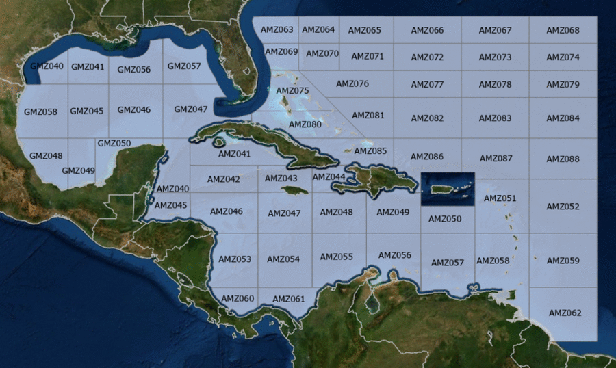
Hover to view popup zone forecast; click a zone to view related text forecast below. Show All Text Below
Southwest Tropical North Atlantic & Caribbean Sea (OFFNT3)
098
FZNT23 KNHC 271416
OFFNT3

Offshore Waters Forecast for the Caribbean Sea and Tropical
N Atlantic
NWS National Hurricane Center Miami, FL
1016 AM EDT Sat Apr 27 2024

Offshore Waters Forecast for Caribbean Sea, and the Tropical N
Atlantic from 07N to 19N W of 55W.

Seas given as significant wave height, which is the average
height of the highest 1/3 of the waves. Individual waves may be
more than twice the significant wave height.
Synopsis for the Caribbean Sea & Tropical North Atlantic
AMZ001-280230-
Synopsis for Caribbean Sea, and Tropical N Atlantic from 07N to
19N W of 55W
1016 AM EDT Sat Apr 27 2024

.SYNOPSIS...Strong high pressure centered off the New England
coast will support fresh to occasionally strong winds in the Gulf
of Honduras, the lee of Cuba, the Windward Passage, and south of
Hispaniola through early next week. Seas will peak near 9 ft
during the period of strongest winds. Moderate to locally fresh
easterly winds will prevail in the rest of the basin. Northerly
swell will bring seas of 8 ft through the passages in the NE
Caribbean early next week.
AMZ040 Zone Forecast
AMZ040-280230-
Caribbean N of 18N W of 85W including Yucatan Basin-
1016 AM EDT Sat Apr 27 2024

.TODAY...E to SE winds 15 to 20 kt. Seas 5 to 7 ft.
.TONIGHT...E winds 15 to 20 kt. Seas 4 to 6 ft.
.SUN...E to SE winds 20 kt. Seas 6 to 8 ft in E swell.
.SUN NIGHT...E winds 15 to 20 kt. Seas 6 to 8 ft in E swell.
.MON...E to SE winds 15 to 20 kt. Seas 5 to 7 ft.
.MON NIGHT...E winds 15 to 20 kt S of 20N, and E to SE 10 to
15 kt N of 20N. Seas 5 to 7 ft.
.TUE...E to SE winds 10 to 15 kt. Seas 4 to 6 ft.
.TUE NIGHT...Winds E winds 10 to 15 kt. Seas 3 to 5 ft.
.WED...E winds 10 to 15 kt. Seas 2 to 4 ft.
.WED NIGHT...E winds 10 to 15 kt. Seas 2 to 4 ft.
Forecaster AL
AMZ041 Zone Forecast
AMZ041-280230-
Caribbean N of 20N E of 85W-
1016 AM EDT Sat Apr 27 2024

.TODAY...E winds 15 to 20 kt. Seas 4 to 6 ft.
.TONIGHT...E winds 20 to 25 kt W of 81W, and NE to E 20 to 25 kt
E of 81W. Seas 5 to 7 ft.
.SUN...E winds 15 to 20 kt. Seas 6 to 8 ft.
.SUN NIGHT...W of 81W, E winds 15 to 20 kt. E of 81W, NE to E
winds 10 to 15 kt, increasing to 20 kt late. Seas 5 to
7 ft.
.MON...Winds E winds 15 to 20 kt. Seas 4 to 6 ft.
.MON NIGHT...W of 81W, E winds 10 to 15 kt. E of 81W, E winds
10 kt, increasing to 15 to 20 kt late. Seas 4 to 6 ft.
.TUE...E to SE winds 10 to 15 kt. Seas 3 to 5 ft.
.TUE NIGHT...NE to E winds 10 to 15 kt. Seas 2 to 4 ft.
.WED...E winds 10 to 15 kt. Seas 3 ft or less.
.WED NIGHT...NE to E winds 10 to 15 kt. Seas 3 ft or less.
Forecaster AL
AMZ042 Zone Forecast
AMZ042-280230-
Caribbean from 18N to 20N between 80W and 85W including Cayman
Basin-
1016 AM EDT Sat Apr 27 2024

.TODAY...E winds 15 to 20 kt. Seas 4 to 6 ft.
.TONIGHT...E winds 15 to 20 kt W of 82W, and NE to E 20 to 25 kt
E of 82W. Seas 5 to 7 ft.
.SUN...E winds 15 to 20 kt. Seas 5 to 7 ft.
.SUN NIGHT...E winds 15 to 20 kt. Seas 5 to 7 ft.
.MON...E winds 15 to 20 kt. Seas 4 to 6 ft.
.MON NIGHT...E winds 10 to 15 kt. Seas 3 to 5 ft.
.TUE...E winds 10 to 15 kt. Seas 3 to 5 ft.
.TUE NIGHT...E winds 10 kt. Seas 2 to 4 ft.
.WED...E winds 10 to 15 kt. Seas 2 to 4 ft.
.WED NIGHT...NE to E winds 10 kt. Seas 3 ft or less.
Forecaster AL
AMZ043 Zone Forecast
AMZ043-280230-
Caribbean from 18N to 20N between 76W and 80W-
1016 AM EDT Sat Apr 27 2024

.TODAY...NE to E winds 15 to 20 kt. Seas 5 to 7 ft.
.TONIGHT...NE to E winds 20 to 25 kt. Seas 6 to 8 ft.
.SUN...NE to E winds 15 to 20 kt. Seas 6 to 9 ft in E swell.
.SUN NIGHT...E winds 15 to 20 kt. Seas 6 to 8 ft. Scattered
showers.
.MON...Winds E winds 15 to 20 kt. Seas 5 to 7 ft.
.MON NIGHT...E winds 10 to 15 kt. Seas 3 to 5 ft.
.TUE...E winds 10 to 15 kt. Seas 4 to 6 ft.
.TUE NIGHT...E winds 10 kt. Seas 2 to 4 ft.
.WED...E winds 10 kt. Seas 2 to 4 ft.
.WED NIGHT...E winds 10 kt. Seas 2 to 4 ft.
Forecaster AL
AMZ044 Zone Forecast
AMZ044-280230-
Caribbean approaches to the Windward Passage-
1016 AM EDT Sat Apr 27 2024

.TODAY...N to NE winds 10 kt in the Gulf of Gonave, and NE to E
20 to 25 kt elsewhere. Seas 5 to 7 ft.
.TONIGHT...NE winds 15 to 20 kt in the Gulf of Gonave, and NE
20 to 25 kt elsewhere. Seas 6 to 9 ft in NE swell.
.SUN...In the Gulf of Gonave, NE winds 10 to 15 kt in the
morning, becoming variable less than 5 kt. Elsewhere, NE to E
winds 20 to 25 kt. Seas 6 to 9 ft in NE swell.
.SUN NIGHT...NE to E winds 10 to 15 kt in the Gulf of Gonave, and
NE to E 20 to 25 kt elsewhere. Seas 6 to 8 ft in NE swell.
Scattered showers.
.MON...In the Gulf of Gonave, NE to E winds 10 kt in the morning,
becoming variable less than 5 kt. Elsewhere, NE to E winds 15 to
20 kt. Seas 2 to 4 ft in the Gulf of Gonave, and 5 to 7 ft
elsewhere.
.MON NIGHT...In the Gulf of Gonave, N winds 10 kt, shifting to E
late. Elsewhere, NE to E winds 15 to 20 kt. Seas 3 ft
or less in the Gulf of Gonave, and 5 to 7 ft elsewhere.
.TUE...E winds 10 to 15 kt. Seas 3 ft or less in the Gulf of
Gonave, and 4 to 6 ft elsewhere.
.TUE NIGHT...In the Gulf of Gonave, variable winds less than
5 kt. Seas 3 ft or less. Elsewhere, NE to E winds 10 to 15 kt,
Seas 5 to 7 ft.
.WED...NE to E winds 10 kt. Seas 3 ft or less in the Gulf of
Gonave, and 3 to 5 ft elsewhere.
.WED NIGHT...In the Gulf of Gonave, NE to E winds 10 kt in the
evening, becoming variable less than 5 kt. Elsewhere, NE to E
winds 10 kt. Seas 2 to 4 ft.
Forecaster AL
AMZ045 Zone Forecast
AMZ045-280230-
S of 18N W of 85W including Gulf of Honduras-
1016 AM EDT Sat Apr 27 2024

.TODAY...E winds 15 to 20 kt. Seas 4 to 6 ft.
.TONIGHT...E winds 20 to 25 kt. Seas 5 to 7 ft.
.SUN...E to SE winds 15 to 20 kt. Seas 5 to 7 ft.
.SUN NIGHT...E winds 20 to 25 kt. Seas 6 to 8 ft.
.MON...E winds 15 to 20 kt S of 17N W of 86W, and E to SE 15 to
20 kt elsewhere. Seas 6 to 8 ft.
.MON NIGHT...Winds E winds 20 to 25 kt. Seas 5 to 7 ft.
.TUE...NE to E winds 15 to 20 kt S of 17N W of 86W, and E 15 to
20 kt elsewhere. Seas 4 to 6 ft.
.TUE NIGHT...E winds 15 to 20 kt. Seas 3 to 5 ft.
.WED...NE to E winds 10 to 15 kt. Seas 2 to 4 ft.
.WED NIGHT...E winds 10 to 15 kt. Seas 3 ft or less.
Forecaster AL
AMZ046 Zone Forecast
AMZ046-280230-
Caribbean from 15N to 18N between 80W and 85W-
1016 AM EDT Sat Apr 27 2024

.TODAY...E winds 15 kt. Seas 3 to 5 ft.
.TONIGHT...E winds 15 to 20 kt W of 82W, and E 10 to 15 kt E of
82W. Seas 4 to 6 ft.
.SUN...E to SE winds 15 to 20 kt W of 82W, and E 10 to 15 kt E of
82W. Seas 4 to 6 ft.
.SUN NIGHT...E to SE winds 15 to 20 kt W of 82W, and E 10 to
15 kt E of 82W. Seas 4 to 6 ft.
.MON...E to SE winds 10 to 15 kt. Seas 4 to 6 ft W of 82W, and
3 to 5 ft E of 82W.
.MON NIGHT...W of 82W, E to SE winds 15 to 20 kt. Seas 3 to 5 ft.
E of 82W, E winds 10 to 15 kt. Seas 2 to 4 ft.
.TUE...E to SE winds 10 to 15 kt. Seas 3 to 5 ft W of 82W, and
2 to 4 ft E of 82W.
.TUE NIGHT...E winds 10 to 15 kt. Seas 2 to 4 ft.
.WED...E winds 10 kt. Seas 2 to 4 ft.
.WED NIGHT...E winds 10 to 15 kt. Seas 3 ft or less W of 82W, and
2 to 4 ft E of 82W.
Forecaster AL
AMZ047 Zone Forecast
AMZ047-280230-
Caribbean from 15N to 18N between 76W and 80W-
1016 AM EDT Sat Apr 27 2024

.TODAY...NE to E winds 15 to 20 kt. Seas 4 to 6 ft.
.TONIGHT...NE to E winds 15 to 20 kt. Seas 5 to 7 ft.
.SUN...E winds 10 to 15 kt. Seas 6 to 8 ft in E swell.
.SUN NIGHT...E winds 10 to 15 kt. Seas 4 to 6 ft.
.MON...E winds 10 to 15 kt. Seas 4 to 6 ft.
.MON NIGHT...E winds 10 to 15 kt. Seas 3 to 5 ft.
.TUE...E winds 10 to 15 kt. Seas 4 to 6 ft.
.TUE NIGHT...E winds 10 to 15 kt. Seas 4 to 6 ft.
.WED...E winds 10 to 15 kt. Seas 4 to 6 ft.
.WED NIGHT...E winds 10 to 15 kt. Seas 3 to 5 ft.
Forecaster AL
AMZ048 Zone Forecast
AMZ048-280230-
Caribbean from 15N to 18N between 72W and 76W-
1016 AM EDT Sat Apr 27 2024

.TODAY...E winds 10 to 15 kt. Seas 3 to 5 ft. Scattered showers.
.TONIGHT...NE to E winds 15 to 20 kt. Seas 3 to 5 ft, building to
6 to 8 ft in E to SE swell late.
.SUN...E winds 15 to 20 kt. Seas 6 to 8 ft.
.SUN NIGHT...E winds 15 to 20 kt. Seas 4 to 6 ft. Scattered
showers.
.MON...E winds 15 to 20 kt. Seas 4 to 6 ft.
.MON NIGHT...E winds 15 to 20 kt S of 17N, and E 20 to 25 kt N of
17N. Seas 5 to 7 ft.
.TUE...E winds 15 to 20 kt. Seas 5 to 7 ft.
.TUE NIGHT...E winds 15 to 20 kt. Seas 5 to 7 ft.
.WED...E winds 15 to 20 kt. Seas 5 to 7 ft.
.WED NIGHT...E winds 10 to 15 kt. Seas 4 to 6 ft.
Forecaster AL
AMZ049 Zone Forecast
AMZ049-280230-
Caribbean N of 15N between 68W and 72W-
1016 AM EDT Sat Apr 27 2024

.TODAY...NE to E winds 15 to 20 kt W of 70W, and NE to E 10 to
15 kt E of 70W. Seas 3 to 5 ft. Scattered showers.
.TONIGHT...NE to E winds 20 to 25 kt W of 70W, and NE to E 15 to
20 kt E of 70W. Seas 4 to 6 ft. Scattered showers.
.SUN...NE to E winds 15 to 20 kt. Seas 5 to 7 ft. Scattered
showers.
.SUN NIGHT...NE to E winds 15 to 20 kt. Seas 4 to 6 ft.
.MON...NE to E winds 15 to 20 kt. Seas 4 to 6 ft.
.MON NIGHT...NE to E winds 20 to 25 kt W of 70W, and NE to E
15 to 20 kt E of 70W. Seas 5 to 7 ft.
.TUE...NE to E winds 15 to 20 kt. Seas 5 to 7 ft.
.TUE NIGHT...NE to E winds 15 to 20 kt. Seas 5 to 7 ft.
.WED...NE to E winds 15 to 20 kt. Seas 5 to 7 ft.
.WED NIGHT...NE to E winds 15 to 20 kt W of 70W, and NE to E
10 to 15 kt E of 70W. Seas 4 to 6 ft.
Forecaster AL
AMZ050 Zone Forecast
AMZ050-280230-
Caribbean N of 15N between 64W and 68W-
1016 AM EDT Sat Apr 27 2024

.TODAY...E winds 10 to 15 kt. Seas 2 to 4 ft. Scattered showers.
.TONIGHT...NE to E winds 10 to 15 kt. Seas 3 to 5 ft.
.SUN...NE to E winds 10 to 15 kt. Seas 3 to 5 ft.
.SUN NIGHT...NE to E winds 10 to 15 kt. Seas 3 to 5 ft.
.MON...NE to E winds 10 to 15 kt. Seas 4 to 6 ft.
.MON NIGHT...NE to E winds 15 to 20 kt. Seas 5 to 7 ft.
.TUE...Winds NE to E winds 15 to 20 kt. Seas 5 to 7 ft.
.TUE NIGHT...NE to E winds 15 to 20 kt. Seas 5 to 7 ft W of 66W,
and 4 to 6 ft E of 66W.
.WED...E winds 10 to 15 kt. Seas 5 to 7 ft W of 66W, and 3 to
5 ft E of 66W.
.WED NIGHT...E winds 10 to 15 kt. Seas 3 to 5 ft.
Forecaster AL
AMZ051 Zone Forecast
AMZ051-280230-
Offshore Waters Leeward Islands-
1016 AM EDT Sat Apr 27 2024

.TODAY...NE to E winds 10 to 15 kt. Seas 3 to 5 ft.
.TONIGHT...NE to E winds 10 to 15 kt. Seas 3 to 5 ft.
.SUN...NE to E winds 10 to 15 kt. Seas 3 to 5 ft. Scattered
showers.
.SUN NIGHT...NE to E winds 10 to 15 kt in the Caribbean, and NE
15 to 20 kt in the Atlc. Seas 5 to 7 ft in NE swell. Scattered
showers.
.MON...NE to E winds 10 to 15 kt in the Caribbean, and NE to E
15 to 20 kt in the Atlc. Seas 6 to 8 ft in N to NE swell.
.MON NIGHT...NE to E winds 10 to 15 kt in the Caribbean, and NE
to E 15 to 20 kt in the Atlc. Seas 6 to 9 ft in N swell.
.TUE...NE to E winds 10 to 15 kt in the Caribbean, and NE to E
15 to 20 kt in the Atlc. Seas 6 to 9 ft in N swell.
.TUE NIGHT...E winds 10 to 15 kt in the Caribbean, and E 15 to
20 kt in the Atlc. Seas 6 to 9 ft in N swell.
.WED...E winds 10 to 15 kt. Seas 6 to 8 ft in N swell.
.WED NIGHT...E winds 10 to 15 kt. Seas 5 to 7 ft in N swell.
Forecaster AL
AMZ052 Zone Forecast
AMZ052-280230-
Tropical N Atlantic from 15N to 19N between 55W and 60W-
1016 AM EDT Sat Apr 27 2024

.TODAY...E winds 10 kt. Seas 4 to 6 ft in NE swell.
.TONIGHT...NE to E winds 10 kt. Seas 3 to 5 ft.
.SUN...S of 17N, E winds 10 kt. N of 17N, E to SE winds 10 kt in
the morning, becoming variable less than 5 kt. Seas 3 to 5 ft.
Scattered showers.
.SUN NIGHT...NE to E winds 10 kt. Seas 3 to 5 ft. Scattered
showers.
.MON...E winds 10 kt. Seas 2 to 4 ft S of 17N, and 5 to 7 ft N of
17N.
.MON NIGHT...NE to E winds 10 to 15 kt. Seas 6 to 8 ft in N to NE
swell.
.TUE...E winds 10 to 15 kt. Seas 6 to 8 ft in N swell.
.TUE NIGHT...E winds 15 kt. Seas 6 to 8 ft in N swell.
.WED...E winds 10 to 15 kt. Seas 6 to 8 ft in N swell.
.WED NIGHT...E winds 10 to 15 kt. Seas 5 to 7 ft in N swell.
Forecaster AL
AMZ053 Zone Forecast
AMZ053-280230-
W Central Caribbean from 11N to 15N W of 80W-
1016 AM EDT Sat Apr 27 2024

.TODAY...NE to E winds 10 to 15 kt. Seas 3 to 5 ft. Scattered
showers.
.TONIGHT...NE to E winds 10 to 15 kt. Seas 3 to 5 ft. Scattered
showers.
.SUN...E winds 10 to 15 kt. Seas 3 to 5 ft.
.SUN NIGHT...E winds 10 to 15 kt. Seas 3 to 5 ft.
.MON...E winds 10 kt. Seas 3 to 5 ft.
.MON NIGHT...E winds 10 to 15 kt. Seas 2 to 4 ft.
.TUE...E winds 10 to 15 kt. Seas 2 to 4 ft.
.TUE NIGHT...E winds 10 kt. Seas 2 to 4 ft.
.WED...NE to E winds 10 kt. Seas 2 to 4 ft.
.WED NIGHT...NE to E winds 10 kt. Seas 2 to 4 ft.
Forecaster AL
AMZ054 Zone Forecast
AMZ054-280230-
Caribbean from 11N to 15N between 76W and 80W-
1016 AM EDT Sat Apr 27 2024

.TODAY...NE to E winds 15 kt. Seas 4 to 6 ft. Scattered showers.
.TONIGHT...NE to E winds 15 kt. Seas 4 to 6 ft.
.SUN...NE to E winds 15 kt. Seas 5 to 7 ft.
.SUN NIGHT...NE to E winds 15 kt. Seas 4 to 6 ft.
.MON...E winds 10 to 15 kt. Seas 3 to 5 ft.
.MON NIGHT...NE to E winds 10 to 15 kt. Seas 3 to 5 ft.
.TUE...E winds 10 to 15 kt. Seas 4 to 6 ft.
.TUE NIGHT...NE to E winds 10 to 15 kt. Seas 4 to 6 ft.
.WED...NE to E winds 10 to 15 kt. Seas 4 to 6 ft.
.WED NIGHT...NE to E winds 10 to 15 kt. Seas 4 to 6 ft.
Forecaster AL
AMZ055 Zone Forecast
AMZ055-280230-
Caribbean from 11N to 15N between 72W and 76W including Colombia
Basin-
1016 AM EDT Sat Apr 27 2024

.TODAY...E winds 15 kt. Seas 4 to 6 ft.
.TONIGHT...NE to E winds 15 to 20 kt. Seas 4 to 6 ft.
.SUN...NE to E winds 15 to 20 kt. Seas 5 to 7 ft.
.SUN NIGHT...NE to E winds 15 kt. Seas 3 to 5 ft.
.MON...E winds 15 kt. Seas 3 to 5 ft.
.MON NIGHT...NE to E winds 15 to 20 kt. Seas 4 to 6 ft.
.TUE...E winds 15 to 20 kt. Seas 5 to 7 ft.
.TUE NIGHT...NE to E winds 15 to 20 kt. Seas 5 to 7 ft.
.WED...NE to E winds 10 to 15 kt. Seas 5 to 7 ft in NE swell.
.WED NIGHT...NE to E winds 15 kt. Seas 4 to 6 ft.
Forecaster AL
AMZ056 Zone Forecast
AMZ056-280230-
Caribbean S of 15N between 68W and 72W including Gulf of
Venezuela-
1016 AM EDT Sat Apr 27 2024

.TODAY...E winds 10 to 15 kt. Seas 3 to 5 ft.
.TONIGHT...NE to E winds 10 to 15 kt. Seas 3 to 5 ft.
.SUN...E winds 10 to 15 kt. Seas 3 to 5 ft.
.SUN NIGHT...NE to E winds 15 kt. Seas 3 to 5 ft.
.MON...E winds 15 kt. Seas 3 to 5 ft.
.MON NIGHT...NE to E winds 15 to 20 kt. Seas 4 to 6 ft.
.TUE...E winds 15 kt. Seas 5 to 7 ft in N to NE swell.
.TUE NIGHT...NE to E winds 15 to 20 kt. Seas 5 to 7 ft.
.WED...E winds 10 to 15 kt. Seas 5 to 7 ft in N to NE swell.
.WED NIGHT...E winds 15 kt. Seas 4 to 6 ft.
Forecaster AL
AMZ057 Zone Forecast
AMZ057-280230-
Caribbean S of 15N between 64W and 68W including Venezuela Basin-
1016 AM EDT Sat Apr 27 2024

.TODAY...E winds 10 to 15 kt. Seas 2 to 4 ft.
.TONIGHT...NE to E winds 10 to 15 kt. Seas 3 to 5 ft.
.SUN...E winds 10 to 15 kt. Seas 3 to 5 ft.
.SUN NIGHT...NE to E winds 10 to 15 kt. Seas 3 to 5 ft.
.MON...E winds 10 to 15 kt. Seas 3 to 5 ft.
.MON NIGHT...NE to E winds 10 to 15 kt. Seas 4 to 6 ft.
.TUE...E winds 10 to 15 kt. Seas 4 to 6 ft.
.TUE NIGHT...NE to E winds 15 kt. Seas 4 to 6 ft.
.WED...E winds 10 to 15 kt. Seas 4 to 6 ft.
.WED NIGHT...E winds 10 to 15 kt. Seas 3 to 5 ft.
Forecaster AL
AMZ058 Zone Forecast
AMZ058-280230-
Offshore Waters Windward Islands including Trinidad and Tobago-
1016 AM EDT Sat Apr 27 2024

.TODAY...E winds 10 to 15 kt. Seas 3 to 5 ft.
.TONIGHT...NE to E winds 10 to 15 kt. Seas 3 to 5 ft.
.SUN...E winds 10 to 15 kt. Seas 3 to 5 ft.
.SUN NIGHT...NE to E winds 10 to 15 kt. Seas 2 to 4 ft.
.MON...E winds 10 to 15 kt. Seas 2 to 4 ft.
.MON NIGHT...NE to E winds 10 to 15 kt. Seas 2 to 4 ft.
.TUE...E winds 10 to 15 kt. Seas 3 to 5 ft.
.TUE NIGHT...E winds 10 to 15 kt. Seas 4 to 6 ft.
.WED...E winds 10 to 15 kt. Seas 4 to 6 ft.
.WED NIGHT...E winds 10 to 15 kt. Seas 4 to 6 ft.
Forecaster AL
AMZ059 Zone Forecast
AMZ059-280230-
Tropical N Atlantic from 11N and 15N between 55W and 60W-
1016 AM EDT Sat Apr 27 2024

.TODAY...E winds 10 kt. Seas 4 to 6 ft in NE swell.
.TONIGHT...NE to E winds 10 kt. Seas 3 to 5 ft.
.SUN...E winds 10 kt. Seas 3 to 5 ft.
.SUN NIGHT...E winds 10 kt. Seas 3 to 5 ft.
.MON...E to SE winds 10 to 15 kt. Seas 2 to 4 ft.
.MON NIGHT...E winds 10 to 15 kt. Seas 2 to 4 ft.
.TUE...E winds 10 to 15 kt. Seas 4 to 6 ft.
.TUE NIGHT...E winds 15 kt. Seas 4 to 6 ft.
.WED...E winds 15 kt. Seas 4 to 6 ft.
.WED NIGHT...E winds 10 to 15 kt. Seas 5 to 7 ft in N swell.
Forecaster AL
AMZ060 Zone Forecast
AMZ060-280230-
SW Caribbean S of 11N W of 80W-
1016 AM EDT Sat Apr 27 2024

.TODAY...Variable winds less than 5 kt S of 10N, and NE 10 kt N
of 10N. Seas 3 to 5 ft. Scattered showers.
.TONIGHT...Variable winds less than 5 kt S of 10N, and NE to E
10 kt N of 10N. Seas 2 to 4 ft. Scattered showers.
.SUN...Variable winds less than 5 kt S of 10N, and NE to E 10 to
15 kt N of 10N. Seas 3 to 5 ft. Scattered showers.
.SUN NIGHT...Variable winds less than 5 kt S of 10N, and E 10 kt
N of 10N. Seas 2 to 4 ft. Scattered showers.
.MON...Variable winds less than 5 kt S of 10N, and NE to E 10 kt
N of 10N. Seas 2 to 4 ft.
.MON NIGHT...Variable winds less than 5 kt S of 10N, and NE to E
10 kt N of 10N. Seas 2 to 4 ft.
.TUE...Variable winds less than 5 kt S of 10N, and NE to E 10 kt
N of 10N. Seas 2 to 4 ft.
.TUE NIGHT...NE winds 10 kt. Seas 2 to 4 ft.
.WED...S of 10N, variable winds less than 5 kt. N of 10N, NE to E
winds 10 kt in the morning, becoming variable less than 5 kt.
Seas 2 to 4 ft.
.WED NIGHT...Variable winds less than 5 kt S of 10N, and NE 10 kt
N of 10N. Seas 2 to 4 ft.
Forecaster AL
AMZ061 Zone Forecast
AMZ061-280230-
SW Caribbean S of 11N E of 80W including the approaches to the
Panama Canal-
1016 AM EDT Sat Apr 27 2024

.TODAY...S of 10N, E to SE winds 10 kt late in the morning,
becoming variable less than 5 kt. N of 10N, E winds 10 to 15 kt.
Seas 3 to 5 ft.
.TONIGHT...N to NE winds 10 to 15 kt. Seas 3 to 5 ft. Scattered
showers.
.SUN...E winds 10 to 15 kt. Seas 4 to 6 ft. Scattered showers.
.SUN NIGHT...N to NE winds 10 to 15 kt. Seas 4 to 6 ft. Scattered
showers.
.MON...NE to E winds 10 kt. Seas 3 to 5 ft.
.MON NIGHT...N to NE winds 10 to 15 kt. Seas 3 to 5 ft.
.TUE...S of 10N, E winds 10 kt in the morning, becoming variable
less than 5 kt. N of 10N, NE to E winds 10 kt. Seas 3 to 5 ft.
.TUE NIGHT...N to NE winds 10 to 15 kt. Seas 3 to 5 ft.
.WED...S of 10N, variable winds less than 5 kt, becoming NW 10 kt
in the afternoon. N of 10N, NE to E winds 10 kt, shifting to N in
the afternoon. Seas 3 to 5 ft.
.WED NIGHT...N winds 10 kt. Seas 3 to 5 ft.
Forecaster AL
AMZ062 Zone Forecast
AMZ062-280230-
Tropical N Atlantic from 7N and 11N between 55W and 60W-
1016 AM EDT Sat Apr 27 2024

.TODAY...NE to E winds 10 kt. Seas 4 to 6 ft in NE swell.
.TONIGHT...NE to E winds 10 to 15 kt. Seas 3 to 5 ft.
.SUN...NE to E winds 10 kt. Seas 3 to 5 ft.
.SUN NIGHT...NE to E winds 10 to 15 kt. Seas 3 to 5 ft.
.MON...E winds 10 to 15 kt. Seas 3 to 5 ft.
.MON NIGHT...NE to E winds 10 to 15 kt. Seas 2 to 4 ft.
.TUE...NE to E winds 10 to 15 kt. Seas 2 to 4 ft.
.TUE NIGHT...NE to E winds 10 to 15 kt. Seas 3 to 5 ft.
.WED...E winds 10 to 15 kt. Seas 4 to 6 ft.
.WED NIGHT...NE to E winds 15 kt. Seas 5 to 7 ft.
Forecaster AL
Southwest North Atlantic (OFFNT5)
000
FZNT25 KNHC 271443
OFFNT5

Offshore Waters Forecast for the SW N Atlantic including the
Bahamas
NWS National Hurricane Center Miami, FL
1043 AM EDT Sat Apr 27 2024

Offshore Waters Forecast for the SW N Atlantic from 19N to 31N W
of 55W including Bahamas.

Seas given as significant wave height, which is the average
height of the highest 1/3 of the waves. Individual waves may be
more than twice the significant wave height.
Synopsis for the Southwest Atlantic
AMZ101-280245-
Synopsis for the SW N Atlantic including the Bahamas
1043 AM EDT Sat Apr 27 2024

.SYNOPSIS...A cold front will move through the eastern waters this
weekend before stalling and weakening over the far southeastern
waters late Sun through Mon night. Northerly swell behind the
front will build seas to a peak of 12 ft over the NE waters by
Sun. Fresh to strong north to northeast winds will prevail N of
28N behind the front tonight through Sun. Moderate to fresh winds
will prevail elsewhere into early next week. More tranquil marine
conditions are expected by midweek as high pressure becomes
centered over the NW waters.
AMZ063 Zone Forecast
AMZ063-280245-
Atlantic from 29N to 31N W of 77W-
1043 AM EDT Sat Apr 27 2024

.TODAY...E winds 20 kt. Seas 6 to 8 ft.
.TONIGHT...E winds 15 to 20 kt. Seas 6 to 8 ft in NE to E swell.
.SUN...E to SE winds 15 to 20 kt. Seas 5 to 7 ft.
.SUN NIGHT...E to SE winds 10 to 15 kt. Seas 4 to 6 ft.
.MON...SE winds 10 kt. Seas 4 to 6 ft in NE to E swell.
.MON NIGHT...SE winds 10 to 15 kt. Seas 4 to 6 ft.
.TUE...SE to S winds 10 kt. Seas 3 to 5 ft.
.TUE NIGHT...S winds 10 to 15 kt. Seas 3 to 5 ft.
.WED...SW winds 10 kt in the morning, becoming variable less than
5 kt. Seas 2 to 4 ft.
.WED NIGHT...S winds 10 kt W of 79W, and variable less than 5 kt
E of 79W. Seas 2 to 4 ft.
Forecaster AL
AMZ064 Zone Forecast
AMZ064-280245-
Atlantic from 29N to 31N between 74W and 77W-
1043 AM EDT Sat Apr 27 2024

.TODAY...NE to E winds 20 kt. Seas 6 to 8 ft in NE swell.
.TONIGHT...NE to E winds 15 to 20 kt. Seas 6 to 8 ft in NE swell.
.SUN...E winds 10 to 15 kt. Seas 5 to 7 ft in NE swell.
.SUN NIGHT...E winds 10 to 15 kt. Seas 5 to 7 ft in NE to E
swell.
.MON...E to SE winds 10 to 15 kt. Seas 4 to 6 ft.
.MON NIGHT...SE winds 10 kt. Seas 4 to 6 ft in NE to E swell.
.TUE...SE to S winds 10 kt. Seas 3 to 5 ft.
.TUE NIGHT...SE to S winds 10 kt. Seas 3 to 5 ft.
.WED...S to SW winds 10 kt. Seas 3 to 5 ft.
.WED NIGHT...W of 75W, variable winds less than 5 kt, becoming S
to SW 10 kt late. E of 75W, S to SW winds 10 kt. Seas
2 to 4 ft.
Forecaster AL
AMZ065 Zone Forecast
AMZ065-280245-
Atlantic from 29N to 31N between 70W and 74W-
1043 AM EDT Sat Apr 27 2024

.TODAY...NE winds 20 kt. Seas 6 to 8 ft in N to NE swell.
.TONIGHT...NE winds 15 to 20 kt. Seas 6 to 8 ft in NE swell.
.SUN...NE to E winds 10 to 15 kt. Seas 6 to 8 ft in NE swell.
.SUN NIGHT...NE to E winds 10 to 15 kt. Seas 6 to 8 ft in NE
swell.
.MON...W of 72W, E to SE winds 10 kt in the morning. Variable
winds less than 5 kt in the afternoon. E of 72W, variable winds
less than 5 kt in the morning. Seas 5 to 7 ft in NE swell.
.MON NIGHT...W of 72W, E winds 10 kt in the evening, becoming
variable less than 5 kt. E of 72W, variable winds less than 5 kt.
Seas 4 to 6 ft.
.TUE...Variable winds less than 5 kt. Seas 3 to 5 ft in NE swell.
.TUE NIGHT...W of 72W, S winds 10 kt late. Variable
winds less than 5 kt in the evening. E of 72W, variable less than
5 kt. Seas 3 to 5 ft in NE swell.
.WED...S winds 10 kt W of 72W, and variable less than 5 kt E of
72W. Seas 2 to 4 ft in NE swell.
.WED NIGHT...S winds 10 kt W of 72W, and variable less than 5 kt
E of 72W. Seas 3 ft or less in NE swell.
Forecaster AL
AMZ066 Zone Forecast
AMZ066-280245-
Atlantic from 29N to 31N between 65W and 70W-
1043 AM EDT Sat Apr 27 2024

.TODAY...N to NE winds 20 kt. Seas 6 to 9 ft in N swell.
.TONIGHT...N to NE winds 20 to 25 kt. Seas 7 to 10 ft in N to NE
swell.
.SUN...N to NE winds 10 to 15 kt. Seas 7 to 10 ft in NE swell.
.SUN NIGHT...N to NE winds 10 to 15 kt. Seas 6 to 9 ft in NE
swell.
.MON...W of 67W, variable winds less than 5 kt, becoming NW 10 kt
in the afternoon. E of 67W, NW to N winds 10 kt. Seas 6 to 9 ft
in NE swell.
.MON NIGHT...NW winds 10 kt. Seas 6 to 8 ft in NE swell.
.TUE...NW winds 10 to 15 kt. Seas 5 to 7 ft in N to NE swell.
.TUE NIGHT...NW winds 10 kt. Seas 5 to 7 ft in N to NE swell.
.WED...Variable winds less than 5 kt W of 67W, and NW to N 10 kt
E of 67W. Seas 3 to 5 ft.
.WED NIGHT...W of 67W, variable winds less than 5 kt in the
evening. Variable winds less than 5 kt late. E of 67W,
NW to N winds 10 kt in the evening. Seas 3 to 5 ft.
Forecaster AL
AMZ067 Zone Forecast
AMZ067-280245-
Atlantic from 29N to 31N between 60W and 65W-
1043 AM EDT Sat Apr 27 2024

.TODAY...N winds 20 to 25 kt W of 62W, and NW to N 15 to 20 kt E
of 62W. Seas 6 to 9 ft in NW to N swell.
.TONIGHT...N winds 20 to 25 kt. Seas 8 to 12 ft in N to NE swell.
.SUN...N winds 15 to 20 kt W of 62W, and NW to N 20 to 25 kt E of
62W. Seas 8 to 12 ft in N to NE swell.
.SUN NIGHT...NW to N winds 15 to 20 kt. Seas 7 to 11 ft in N to
NE swell.
.MON...NW to N winds 15 to 20 kt. Seas 8 to 12 ft in N to NE
swell.
.MON NIGHT...W to NW winds 10 to 15 kt W of 62W, and W to NW
15 to 20 kt E of 62W. Seas 7 to 10 ft in N to NE swell.
.TUE...W to NW winds 10 to 15 kt W of 62W, and W to NW 15 to
20 kt E of 62W. Seas 6 to 9 ft in N to NE swell.
.TUE NIGHT...NW to N winds 10 kt W of 62W, and NW to N 10 to
15 kt E of 62W. Seas 6 to 8 ft in N to NE swell.
.WED...W of 62W, variable winds less than 5 kt in the morning.
Variable winds less than 5 kt in the afternoon. E of 62W, N winds
10 kt in the morning. Seas 5 to 7 ft.
.WED NIGHT...Variable winds less than 5 kt. Seas 5 to 7 ft in N
to NE swell.
Forecaster AL
AMZ068 Zone Forecast
AMZ068-280245-
Atlantic from 29N to 31N between 55W and 60W-
1043 AM EDT Sat Apr 27 2024

.TODAY...NW winds 15 to 20 kt. Seas 4 to 6 ft. Scattered showers.
.TONIGHT...NW to N winds 20 to 25 kt. Seas 7 to 11 ft in NW to N
swell.
.SUN...NW winds 20 to 25 kt. Seas 8 to 12 ft in NW to N swell.
.SUN NIGHT...NW winds 15 to 20 kt W of 57W, and W to NW 20 to
25 kt E of 57W. Seas 8 to 12 ft in NW swell.
.MON...NW winds 15 to 20 kt. Seas 8 to 12 ft in N swell.
.MON NIGHT...W to NW winds 10 to 15 kt. Seas 7 to 11 ft in N
swell.
.TUE...W winds 15 to 20 kt. Seas 6 to 9 ft in N swell.
.TUE NIGHT...NW winds 15 to 20 kt. Seas 6 to 9 ft in N swell.
.WED...NW to N winds 10 kt. Seas 6 to 8 ft in N swell.
.WED NIGHT...Variable winds less than 5 kt. Seas 6 to 8 ft in N
swell.
Forecaster AL
AMZ069 Zone Forecast
AMZ069-280245-
Atlantic from 27N to 29N W of 77W-
1043 AM EDT Sat Apr 27 2024

.TODAY...E winds 20 kt. Seas 6 to 8 ft.
.TONIGHT...E winds 20 kt. Seas 6 to 8 ft in NE swell.
.SUN...E winds 15 to 20 kt. Seas 6 to 8 ft.
.SUN NIGHT...E winds 15 kt. Seas 5 to 7 ft in NE swell.
.MON...E to SE winds 10 to 15 kt. Seas 5 to 7 ft in NE swell.
.MON NIGHT...E to SE winds 15 kt. Seas 4 to 6 ft.
.TUE...E to SE winds 10 kt. Seas 4 to 6 ft in NE swell.
.TUE NIGHT...SE winds 10 to 15 kt. Seas 3 to 5 ft.
.WED...Variable winds less than 5 kt. Seas 3 to 5 ft in NE swell.
.WED NIGHT...SE winds 10 kt. Seas 2 to 4 ft.
Forecaster AL
AMZ070 Zone Forecast
AMZ070-280245-
Atlantic from 27N to 29N between 74W and 77W-
1043 AM EDT Sat Apr 27 2024

.TODAY...NE to E winds 20 kt. Seas 6 to 8 ft.
.TONIGHT...NE to E winds 15 to 20 kt. Seas 6 to 9 ft in NE swell.
.SUN...E winds 15 to 20 kt. Seas 6 to 8 ft in NE swell.
.SUN NIGHT...NE to E winds 15 to 20 kt. Seas 6 to 8 ft.
.MON...E winds 10 to 15 kt. Seas 5 to 7 ft in NE swell.
.MON NIGHT...E to SE winds 10 to 15 kt. Seas 5 to 7 ft in NE
swell.
.TUE...E to SE winds 10 kt. Seas 4 to 6 ft in NE swell.
.TUE NIGHT...SE winds 10 kt. Seas 4 to 6 ft in NE swell.
.WED...SE winds 10 kt. Seas 4 to 6 ft in NE swell.
.WED NIGHT...W of 75W, SE winds 10 kt. E of 75W, E to SE winds
10 kt in the evening, becoming variable less than 5 kt. Seas 3 to
5 ft.
Forecaster AL
AMZ071 Zone Forecast
AMZ071-280245-
Atlantic from 27N to 29N between 70W and 74W-
1043 AM EDT Sat Apr 27 2024

.TODAY...NE winds 20 kt. Seas 6 to 8 ft in N to NE swell.
.TONIGHT...NE winds 15 to 20 kt. Seas 6 to 9 ft in N to NE swell.
.SUN...NE to E winds 15 to 20 kt. Seas 6 to 8 ft in NE swell.
.SUN NIGHT...NE to E winds 10 to 15 kt. Seas 6 to 8 ft in NE
swell.
.MON...E winds 10 to 15 kt. Seas 5 to 7 ft in NE swell.
.MON NIGHT...E winds 10 to 15 kt. Seas 4 to 6 ft.
.TUE...E winds 10 kt. Seas 4 to 6 ft in NE swell.
.TUE NIGHT...E to SE winds 10 kt. Seas 4 to 6 ft in NE swell.
.WED...E to SE winds 10 kt. Seas 3 to 5 ft.
.WED NIGHT...SE winds 10 kt. Seas 3 to 5 ft.
Forecaster AL
AMZ072 Zone Forecast
AMZ072-280245-
Atlantic from 27N to 29N between 65W and 70W-
1043 AM EDT Sat Apr 27 2024

.TODAY...N to NE winds 20 kt. Seas 6 to 8 ft in N swell.
.TONIGHT...NE winds 15 to 20 kt. Seas 6 to 9 ft in N to NE swell.
.SUN...NE winds 15 to 20 kt. Seas 6 to 9 ft in N to NE swell.
.SUN NIGHT...NE winds 10 to 15 kt. Seas 6 to 8 ft in NE swell.
.MON...N to NE winds 10 kt. Seas 6 to 8 ft in NE swell.
.MON NIGHT...N to NE winds 10 kt. Seas 5 to 7 ft in N to NE
swell.
.TUE...W of 67W, NE winds 10 kt. E of 67W, variable winds less
than 5 kt, becoming NW to N 10 kt in the afternoon. Seas 5 to
7 ft in NE swell.
.TUE NIGHT...W of 67W, NE to E winds 10 kt. E of 67W, N winds
10 kt in the evening, becoming variable less than 5 kt. Seas 4 to
6 ft in N to NE swell.
.WED...Variable winds less than 5 kt. Seas 3 to 5 ft in N to NE
swell.
.WED NIGHT...NE winds 10 kt in the evening, becoming variable
less than 5 kt. Seas 2 to 4 ft.
Forecaster AL
AMZ073 Zone Forecast
AMZ073-280245-
Atlantic from 27N to 29N between 60W and 65W-
1043 AM EDT Sat Apr 27 2024

.TODAY...N winds 15 to 20 kt. Seas 5 to 7 ft.
.TONIGHT...N to NE winds 15 to 20 kt. Seas 7 to 10 ft in NW to N
swell.
.SUN...N winds 15 to 20 kt. Seas 7 to 10 ft in N to NE swell.
.SUN NIGHT...N winds 15 to 20 kt. Seas 7 to 10 ft in N to NE
swell.
.MON...NW to N winds 10 to 15 kt. Seas 6 to 9 ft in N to NE
swell.
.MON NIGHT...NW to N winds 10 to 15 kt. Seas 6 to 9 ft in N to NE
swell.
.TUE...NW winds 10 to 15 kt. Seas 6 to 8 ft in N to NE swell.
.TUE NIGHT...NW winds 10 to 15 kt. Seas 5 to 7 ft in N to NE
swell.
.WED...W of 62W, variable winds less than 5 kt. E of 62W, NW to N
winds 10 kt in the morning, becoming variable less than 5 kt.
Seas 4 to 6 ft.
.WED NIGHT...Variable winds less than 5 kt. Seas 4 to 6 ft in N
to NE swell.
Forecaster AL
AMZ074 Zone Forecast
AMZ074-280245-
Atlantic from 27N to 29N between 55W and 60W-
1043 AM EDT Sat Apr 27 2024

.TODAY...W to NW winds 10 to 15 kt. Seas 4 to 6 ft.
.TONIGHT...NW to N winds 15 to 20 kt. Seas 5 to 7 ft.
.SUN...NW to N winds 15 to 20 kt. Seas 7 to 11 ft in NW to N
swell.
.SUN NIGHT...NW winds 15 to 20 kt. Seas 7 to 10 ft in N swell.
.MON...NW winds 10 to 15 kt. Seas 7 to 10 ft in N swell.
.MON NIGHT...NW winds 10 to 15 kt. Seas 7 to 10 ft in N swell.
.TUE...W to NW winds 10 to 15 kt. Seas 6 to 9 ft in N swell.
.TUE NIGHT...W to NW winds 10 to 15 kt. Seas 6 to 8 ft in N
swell.
.WED...NW to N winds 10 kt. Seas 6 to 8 ft in N swell.
.WED NIGHT...Variable winds less than 5 kt. Seas 5 to 7 ft in N
swell.
Forecaster AL
AMZ075 Zone Forecast
AMZ075-280245-
Northern Bahamas from 24N to 27N-
1043 AM EDT Sat Apr 27 2024

.TODAY...NE to E winds 20 kt. Seas 5 to 7 ft.
.TONIGHT...NE to E winds 20 to 25 kt. Seas 6 to 9 ft in NE to E
swell.
.SUN...E winds 15 to 20 kt. Seas 6 to 9 ft in NE swell.
.SUN NIGHT...E winds 15 to 20 kt. Seas 6 to 8 ft.
.MON...E winds 15 to 20 kt. Seas 6 to 8 ft in NE to E swell.
.MON NIGHT...E winds 15 to 20 kt. Seas 5 to 7 ft.
.TUE...E to SE winds 10 to 15 kt. Seas 5 to 7 ft in NE to E
swell.
.TUE NIGHT...E to SE winds 10 to 15 kt. Seas 4 to 6 ft.
.WED...E winds 10 kt. Seas 4 to 6 ft in NE to E swell.
.WED NIGHT...E winds 10 to 15 kt. Seas 3 to 5 ft.
Forecaster AL
AMZ076 Zone Forecast
AMZ076-280245-
Atlantic from 22N to 27N E of Bahamas to 70W-
1043 AM EDT Sat Apr 27 2024

.TODAY...NE winds 20 kt. Seas 5 to 7 ft.
.TONIGHT...NE to E winds 15 to 20 kt. Seas 6 to 9 ft in N to NE
swell.
.SUN...NE to E winds 15 to 20 kt. Seas 6 to 9 ft in N to NE
swell.
.SUN NIGHT...NE to E winds 15 to 20 kt. Seas 6 to 8 ft in NE
swell.
.MON...E winds 15 to 20 kt. Seas 6 to 8 ft in NE swell.
.MON NIGHT...E winds 15 kt. Seas 5 to 7 ft in NE swell.
.TUE...E winds 10 to 15 kt. Seas 5 to 7 ft in NE swell.
.TUE NIGHT...E winds 10 to 15 kt. Seas 4 to 6 ft.
.WED...E winds 10 to 15 kt. Seas 4 to 6 ft.
.WED NIGHT...E winds 10 to 15 kt. Seas 3 to 5 ft.
Forecaster AL
AMZ077 Zone Forecast
AMZ077-280245-
Atlantic from 22N to 27N between 65W and 70W-
1043 AM EDT Sat Apr 27 2024

.TODAY...NE winds 20 kt. Seas 5 to 7 ft.
.TONIGHT...NE winds 15 to 20 kt. Seas 6 to 8 ft in N swell.
.SUN...NE winds 15 to 20 kt. Seas 6 to 9 ft in N to NE swell.
.SUN NIGHT...NE winds 15 kt. Seas 6 to 9 ft in N to NE swell.
.MON...NE winds 10 to 15 kt. Seas 6 to 8 ft in N to NE swell.
.MON NIGHT...NE to E winds 10 to 15 kt. Seas 5 to 7 ft in N to NE
swell.
.TUE...NE to E winds 10 kt. Seas 5 to 7 ft in N to NE swell.
.TUE NIGHT...E winds 10 to 15 kt. Seas 5 to 7 ft in N to NE
swell.
.WED...E winds 10 kt. Seas 4 to 6 ft in N to NE swell.
.WED NIGHT...E winds 10 kt. Seas 3 to 5 ft.
Forecaster AL
AMZ078 Zone Forecast
AMZ078-280245-
Atlantic from 25N to 27N between 60W and 65W-
1043 AM EDT Sat Apr 27 2024

.TODAY...N winds 15 to 20 kt. Seas 5 to 7 ft.
.TONIGHT...N to NE winds 15 to 20 kt. Seas 6 to 8 ft.
.SUN...N to NE winds 15 to 20 kt. Seas 7 to 10 ft in N swell.
.SUN NIGHT...N to NE winds 10 to 15 kt. Seas 6 to 9 ft in N to NE
swell.
.MON...N winds 10 to 15 kt. Seas 6 to 9 ft in N to NE swell.
.MON NIGHT...N to NE winds 10 to 15 kt. Seas 6 to 8 ft in N to NE
swell.
.TUE...W of 62W, NE winds 10 kt. E of 62W, N to NE winds 10 kt in
the morning, becoming variable less than 5 kt. Seas 6 to 8 ft in
N to NE swell.
.TUE NIGHT...W of 62W, NE winds 10 kt. E of 62W, N winds 10 kt in
the evening, becoming variable less than 5 kt. Seas 5 to 7 ft in
N to NE swell.
.WED...E winds 10 kt W of 62W, and variable less than 5 kt E of
62W. Seas 4 to 6 ft.
.WED NIGHT...E winds 10 kt W of 62W, and variable less than 5 kt
E of 62W. Seas 3 to 5 ft.
Forecaster AL
AMZ079 Zone Forecast
AMZ079-280245-
Atlantic from 25N to 27N between 55W and 60W-
1043 AM EDT Sat Apr 27 2024

.TODAY...W to NW winds 10 kt. Seas 3 to 5 ft.
.TONIGHT...NW to N winds 10 to 15 kt. Seas 4 to 6 ft.
.SUN...N winds 15 to 20 kt. Seas 6 to 9 ft in NW to N swell.
.SUN NIGHT...N winds 10 to 15 kt. Seas 7 to 10 ft in NW to N
swell.
.MON...NW to N winds 10 kt. Seas 6 to 9 ft in N swell.
.MON NIGHT...N winds 10 to 15 kt. Seas 6 to 8 ft in N swell.
.TUE...N winds 10 kt. Seas 6 to 8 ft in N swell.
.TUE NIGHT...W of 57W, N winds 10 kt in the evening, becoming
variable less than 5 kt. E of 57W, variable winds less than 5 kt.
Seas 5 to 7 ft in N swell.
.WED...W of 57W, variable less than 5 kt. Variable winds less
than 5 kt in the morning. E of 57W, NW winds 10 kt in the
afternoon. Seas 4 to 6 ft in N swell.
.WED NIGHT...Variable winds less than 5 kt. Seas 4 to 6 ft in N
swell.
Forecaster AL
AMZ080 Zone Forecast
AMZ080-280245-
Central Bahamas including Cay Sal Bank-
1043 AM EDT Sat Apr 27 2024

.TODAY...NE to E winds 20 to 25 kt. Seas 6 to 8 ft.
.TONIGHT...NE to E winds 20 to 25 kt. Seas 6 to 8 ft.
.SUN...E winds 20 to 25 kt. Seas 6 to 9 ft in NE to E swell.
.SUN NIGHT...NE to E winds 15 to 20 kt. Seas 6 to 8 ft in NE to E
swell.
.MON...E winds 15 to 20 kt. Seas 6 to 9 ft in NE to E swell.
.MON NIGHT...E winds 15 to 20 kt. Seas 6 to 8 ft in NE to E
swell.
.TUE...E winds 15 to 20 kt. Seas 5 to 7 ft.
.TUE NIGHT...E winds 15 to 20 kt. Seas 5 to 7 ft.
.WED...E winds 10 to 15 kt. Seas 4 to 6 ft.
.WED NIGHT...E winds 10 to 15 kt. Seas 4 to 6 ft.
Forecaster AL
AMZ081 Zone Forecast
AMZ081-280245-
Atlantic from 22N to 25N E of Bahamas to 70W-
1043 AM EDT Sat Apr 27 2024

.TODAY...NE winds 20 kt. Seas 6 to 8 ft in NE to E swell.
.TONIGHT...NE to E winds 20 to 25 kt. Seas 6 to 8 ft.
.SUN...NE to E winds 15 to 20 kt. Seas 6 to 9 ft in NE swell.
.SUN NIGHT...NE to E winds 15 to 20 kt. Seas 6 to 9 ft in N to NE
swell.
.MON...NE to E winds 15 to 20 kt. Seas 6 to 9 ft in NE swell.
.MON NIGHT...E winds 15 to 20 kt. Seas 6 to 8 ft in NE swell.
.TUE...E winds 15 kt. Seas 6 to 8 ft in NE swell.
.TUE NIGHT...E winds 15 kt. Seas 5 to 7 ft in NE swell.
.WED...E winds 10 to 15 kt. Seas 5 to 7 ft in NE swell.
.WED NIGHT...E winds 10 to 15 kt. Seas 4 to 6 ft.
Forecaster AL
AMZ082 Zone Forecast
AMZ082-280245-
Atlantic from 22N to 25N between 65W and 70W-
1043 AM EDT Sat Apr 27 2024

.TODAY...NE winds 15 to 20 kt. Seas 5 to 7 ft.
.TONIGHT...NE winds 15 to 20 kt. Seas 6 to 8 ft in NE swell.
.SUN...NE winds 15 to 20 kt. Seas 6 to 8 ft in NE swell.
.SUN NIGHT...NE to E winds 15 to 20 kt. Seas 6 to 9 ft in N to NE
swell.
.MON...NE to E winds 15 to 20 kt S of 23N, and NE to E 10 to
15 kt N of 23N. Seas 6 to 9 ft in N to NE swell.
.MON NIGHT...NE to E winds 15 to 20 kt. Seas 6 to 8 ft in N to NE
swell.
.TUE...NE to E winds 10 to 15 kt. Seas 5 to 7 ft in N to NE
swell.
.TUE NIGHT...E winds 10 to 15 kt. Seas 5 to 7 ft in N to NE
swell.
.WED...E winds 10 to 15 kt. Seas 5 to 7 ft in N to NE swell.
.WED NIGHT...E winds 10 to 15 kt. Seas 4 to 6 ft.
Forecaster AL
AMZ083 Zone Forecast
AMZ083-280245-
Atlantic from 22N to 25N between 60W and 65W-
1043 AM EDT Sat Apr 27 2024

.TODAY...N to NE winds 10 to 15 kt. Seas 5 to 7 ft in NE to E
swell.
.TONIGHT...N to NE winds 15 to 20 kt. Seas 6 to 8 ft in NE to E
swell.
.SUN...N to NE winds 15 to 20 kt. Seas 6 to 8 ft.
.SUN NIGHT...NE winds 15 to 20 kt. Seas 6 to 9 ft in N swell.
.MON...NE winds 15 to 20 kt S of 23N, and N to NE 10 to 15 kt N
of 23N. Seas 6 to 8 ft in N swell.
.MON NIGHT...NE winds 10 to 15 kt. Seas 6 to 8 ft in N to NE
swell.
.TUE...NE to E winds 10 to 15 kt. Seas 5 to 7 ft in N to NE
swell.
.TUE NIGHT...NE to E winds 10 to 15 kt. Seas 5 to 7 ft in N to NE
swell.
.WED...E winds 10 to 15 kt. Seas 5 to 7 ft in N to NE swell.
.WED NIGHT...E winds 10 to 15 kt. Seas 4 to 6 ft.
Forecaster AL
AMZ084 Zone Forecast
AMZ084-280245-
Atlantic from 22N to 25N between 55W and 60W-
1043 AM EDT Sat Apr 27 2024

.TODAY...S of 23N, E winds 10 kt late in the morning, becoming
variable less than 5 kt. N of 23N, variable winds less than 5 kt.
Seas 4 to 6 ft.
.TONIGHT...N winds 10 to 15 kt. Seas 4 to 6 ft.
.SUN...N to NE winds 10 to 15 kt. Seas 4 to 6 ft.
.SUN NIGHT...N to NE winds 10 to 15 kt. Seas 6 to 9 ft in NW to N
swell.
.MON...N to NE winds 10 to 15 kt. Seas 6 to 9 ft in NW to N
swell.
.MON NIGHT...NE winds 10 to 15 kt S of 23N, and N to NE 10 to
15 kt N of 23N. Seas 6 to 8 ft in N swell.
.TUE...NE winds 10 to 15 kt. Seas 5 to 7 ft in N swell.
.TUE NIGHT...NE winds 10 to 15 kt. Seas 5 to 7 ft in N swell.
.WED...NE to E winds 10 kt. Seas 5 to 7 ft in N swell.
.WED NIGHT...E winds 10 to 15 kt. Seas 4 to 6 ft.
Forecaster AL
AMZ085 Zone Forecast
AMZ085-280245-
Atlantic S of 22N W of 70W including approaches to the Windward
Passage-
1043 AM EDT Sat Apr 27 2024

.TODAY...NE to E winds 20 to 25 kt. Seas 6 to 8 ft. Scattered
showers.
.TONIGHT...NE to E winds 20 to 25 kt. Seas 6 to 8 ft.
.SUN...NE to E winds 20 kt. Seas 6 to 8 ft in NE to E swell.
.SUN NIGHT...NE to E winds 15 to 20 kt. Seas 6 to 8 ft in NE to E
swell.
.MON...NE to E winds 15 to 20 kt. Seas 6 to 8 ft in NE to E
swell.
.MON NIGHT...E winds 15 to 20 kt. Seas 6 to 8 ft in NE to E
swell.
.TUE...E winds 15 to 20 kt. Seas 6 to 8 ft.
.TUE NIGHT...E winds 15 to 20 kt. Seas 5 to 7 ft.
.WED...E winds 10 to 15 kt. Seas 5 to 7 ft in NE to E swell.
.WED NIGHT...E winds 10 to 15 kt. Seas 4 to 6 ft.
Forecaster AL
AMZ086 Zone Forecast
AMZ086-280245-
Atlantic S of 22N between 65W and 70W including Puerto Rico
Trench-
1043 AM EDT Sat Apr 27 2024

.TODAY...NE winds 10 to 15 kt S of 21N, and NE 15 to 20 kt N of
21N. Seas 6 to 8 ft in NE swell. Scattered showers.
.TONIGHT...NE winds 15 to 20 kt. Seas 6 to 8 ft.
.SUN...NE winds 15 to 20 kt. Seas 6 to 8 ft in NE to E swell.
.SUN NIGHT...NE to E winds 15 to 20 kt. Seas 6 to 8 ft in NE
swell.
.MON...NE to E winds 15 to 20 kt. Seas 6 to 8 ft in N to NE
swell.
.MON NIGHT...NE to E winds 15 to 20 kt. Seas 6 to 8 ft in N to NE
swell.
.TUE...NE to E winds 15 kt. Seas 6 to 8 ft in N to NE swell.
.TUE NIGHT...E winds 15 to 20 kt. Seas 5 to 7 ft.
.WED...NE to E winds 10 to 15 kt. Seas 5 to 7 ft in N to NE
swell.
.WED NIGHT...E winds 10 to 15 kt. Seas 5 to 7 ft in N to NE
swell.
Forecaster AL
AMZ087 Zone Forecast
AMZ087-280245-
Atlantic from 19N to 22N between 60W and 65W-
1043 AM EDT Sat Apr 27 2024

.TODAY...NE winds 10 kt. Seas 3 to 5 ft.
.TONIGHT...NE winds 10 to 15 kt. Seas 4 to 6 ft.
.SUN...NE winds 15 to 20 kt. Seas 5 to 7 ft.
.SUN NIGHT...NE winds 15 to 20 kt. Seas 5 to 7 ft.
.MON...NE winds 15 to 20 kt. Seas 6 to 8 ft in N swell.
.MON NIGHT...NE winds 20 kt S of 20N, and NE 15 to 20 kt N of
20N. Seas 6 to 9 ft in N swell.
.TUE...NE winds 15 to 20 kt. Seas 6 to 9 ft in N swell.
.TUE NIGHT...NE to E winds 15 to 20 kt S of 20N, and NE to E
15 kt N of 20N. Seas 6 to 8 ft in N to NE swell.
.WED...NE to E winds 15 to 20 kt. Seas 6 to 8 ft in N to NE
swell.
.WED NIGHT...E winds 15 to 20 kt. Seas 5 to 7 ft.
Forecaster AL
AMZ088 Zone Forecast
AMZ088-280245-
Atlantic from 19N to 22N between 55W and 60W-
1043 AM EDT Sat Apr 27 2024

.TODAY...E winds 10 kt. Seas 4 to 6 ft in NE to E swell.
Scattered showers.
.TONIGHT...NE to E winds 10 kt. Seas 3 to 5 ft. Scattered
showers.
.SUN...NE winds 10 to 15 kt. Seas 4 to 6 ft. Scattered showers.
.SUN NIGHT...NE to E winds 10 to 15 kt S of 20N, and NE 15 to
20 kt N of 20N. Seas 5 to 7 ft in NE to E swell. Scattered
showers.
.MON...NE winds 15 to 20 kt. Seas 6 to 8 ft in N swell.
.MON NIGHT...NE winds 15 to 20 kt. Seas 6 to 8 ft in N swell.
.TUE...NE winds 15 to 20 kt. Seas 6 to 8 ft in N swell.
.TUE NIGHT...NE to E winds 15 to 20 kt S of 20N, and NE to E
10 to 15 kt N of 20N. Seas 6 to 8 ft in N swell.
.WED...NE to E winds 15 to 20 kt S of 20N, and NE to E 10 to
15 kt N of 20N. Seas 6 to 8 ft in N swell.
.WED NIGHT...NE to E winds 10 to 15 kt. Seas 5 to 7 ft in N
swell.
Forecaster AL
Gulf of Mexico (OFFNT4)
000
FZNT24 KNHC 271421
OFFNT4

Offshore Waters Forecast for the Gulf of Mexico
NWS National Hurricane Center Miami, FL
1021 AM EDT Sat Apr 27 2024

Offshore Waters Forecast for the Gulf of Mexico

Seas given as significant wave height, which is the average
height of the highest 1/3 of the waves. Individual waves may be
more than twice the significant wave height.
Synopsis for the Gulf of Mexico
GMZ001-280230-
Synopsis for the Gulf of Mexico
1021 AM EDT Sat Apr 27 2024

.SYNOPSIS...The pressure gradient between a ridge across the SE
United States and lower pressure across eastern Mexico will
support fresh to strong southeast winds over much of the Gulf
through Sun night. Seas are expected to peak near 10 ft in the NW
and central Gulf today and Sun. Winds will pulse to fresh to
strong speeds near the Yucatan Peninsula each evening through the
forecast period.
GMZ040 Zone Forecast
GMZ040-280230-
NW Gulf including Stetson Bank-
1021 AM EDT Sat Apr 27 2024

.TODAY...SE winds 25 kt. Seas 7 to 10 ft in SE swell.
.TONIGHT...SE winds 25 kt. Seas 7 to 10 ft in SE swell.
.SUN...SE winds 25 kt, diminishing to 15 to 20 kt in the
afternoon. Seas 7 to 11 ft in SE swell.
.SUN NIGHT...SE winds 15 to 20 kt. Seas 7 to 10 ft in SE swell.
.MON...SE winds 10 to 15 kt. Seas 6 to 8 ft in E to SE swell.
.MON NIGHT...SE winds 10 to 15 kt. Seas 5 to 7 ft in E to SE
swell.
.TUE...SE winds 15 kt. Seas 5 to 7 ft.
.TUE NIGHT...SE winds 15 to 20 kt. Seas 4 to 6 ft.
.WED...SE winds 15 to 20 kt. Seas 4 to 6 ft.
.WED NIGHT...SE winds 15 to 20 kt. Seas 5 to 7 ft.
Forecaster AL
GMZ041 Zone Forecast
GMZ041-280230-
SW Louisiana Offshore Waters including Flower Garden Bank Marine
Sanctuary-
1021 AM EDT Sat Apr 27 2024

.TODAY...SE winds 20 to 25 kt. Seas 7 to 10 ft in SE swell.
.TONIGHT...E to SE winds 20 to 25 kt. Seas 7 to 10 ft in SE
swell.
.SUN...SE winds 20 to 25 kt. Seas 7 to 10 ft in E to SE swell.
.SUN NIGHT...SE winds 15 to 20 kt. Seas 7 to 10 ft in E to SE
swell.
.MON...SE to S winds 15 to 20 kt. Seas 6 to 9 ft in E to SE
swell.
.MON NIGHT...SE winds 10 to 15 kt. Seas 6 to 8 ft in E to SE
swell.
.TUE...SE winds 10 to 15 kt. Seas 5 to 7 ft in E to SE swell.
.TUE NIGHT...SE winds 10 to 15 kt. Seas 4 to 6 ft.
.WED...SE winds 15 kt. Seas 4 to 6 ft.
.WED NIGHT...SE winds 15 to 20 kt. Seas 5 to 7 ft.
Forecaster AL
GMZ045 Zone Forecast
GMZ045-280230-
W Central Gulf from 22N to 26N between 91W and 94W-
1021 AM EDT Sat Apr 27 2024

.TODAY...SE winds 20 to 25 kt. Seas 7 to 10 ft in E to SE swell.
.TONIGHT...E to SE winds 20 to 25 kt. Seas 7 to 10 ft in E swell.
.SUN...SE winds 20 to 25 kt. Seas 7 to 10 ft in E swell.
.SUN NIGHT...E to SE winds 20 to 25 kt. Seas 6 to 9 ft in E
swell.
.MON...SE winds 20 kt, diminishing to 10 to 15 kt in the
afternoon. Seas 6 to 9 ft in E swell.
.MON NIGHT...E to SE winds 15 to 20 kt. Seas 6 to 8 ft.
.TUE...E to SE winds 10 to 15 kt. Seas 5 to 7 ft in E swell.
.TUE NIGHT...E to SE winds 15 to 20 kt. Seas 5 to 7 ft.
.WED...E to SE winds 15 to 20 kt. Seas 5 to 7 ft.
.WED NIGHT...E to SE winds 15 to 20 kt. Seas 5 to 7 ft.
Forecaster AL
GMZ046 Zone Forecast
GMZ046-280230-
Central Gulf from 22N to 26N between 87W and 91W-
1021 AM EDT Sat Apr 27 2024

.TODAY...E to SE winds 20 kt. Seas 6 to 8 ft in E swell.
.TONIGHT...E to SE winds 20 to 25 kt. Seas 6 to 9 ft in E swell.
.SUN...E to SE winds 20 to 25 kt. Seas 7 to 10 ft in E swell.
.SUN NIGHT...E to SE winds 20 to 25 kt. Seas 6 to 9 ft in E
swell.
.MON...E to SE winds 15 to 20 kt. Seas 6 to 9 ft in E swell.
.MON NIGHT...E to SE winds 15 to 20 kt. Seas 5 to 7 ft.
.TUE...E to SE winds 10 to 15 kt. Seas 5 to 7 ft in E swell.
.TUE NIGHT...E winds 15 to 20 kt. Seas 5 to 7 ft.
.WED...E to SE winds 10 to 15 kt. Seas 5 to 7 ft in E swell.
.WED NIGHT...E to SE winds 15 to 20 kt. Seas 4 to 6 ft.
Forecaster AL
GMZ047 Zone Forecast
GMZ047-280230-
SE Gulf from 22N to 26N E of 87W including Straits of Florida-
1021 AM EDT Sat Apr 27 2024

.TODAY...E to SE winds 15 to 20 kt. Seas 6 to 8 ft in E swell.
.TONIGHT...E winds 20 to 25 kt. Seas 7 to 10 ft in E swell.
.SUN...E to SE winds 20 to 25 kt. Seas 7 to 10 ft in E swell.
.SUN NIGHT...E winds 15 to 20 kt. Seas 6 to 9 ft in E swell.
.MON...E to SE winds 15 to 20 kt. Seas 6 to 8 ft in E swell.
.MON NIGHT...E winds 10 to 15 kt. Seas 5 to 7 ft in E swell.
.TUE...E winds 10 to 15 kt. Seas 3 to 5 ft.
.TUE NIGHT...E winds 10 to 15 kt. Seas 3 to 5 ft.
.WED...E winds 10 to 15 kt. Seas 2 to 4 ft.
.WED NIGHT...E winds 10 to 15 kt. Seas 3 to 5 ft.
Forecaster AL
GMZ048 Zone Forecast
GMZ048-280230-
SW Gulf S of 22N W of 94W-
1021 AM EDT Sat Apr 27 2024

.TODAY...SE winds 20 to 25 kt. Seas 6 to 8 ft.
.TONIGHT...E to SE winds 15 to 20 kt. Seas 6 to 8 ft in NE to E
swell.
.SUN...S of 21N W of 95W, SE to S winds 15 to 20 kt, shifting to
E to SE 10 kt in the afternoon. Elsewhere, SE winds 15 to 20 kt.
Seas 6 to 9 ft in NE to E swell.
.SUN NIGHT...E to SE winds 15 to 20 kt. Seas 6 to 8 ft.
.MON...E to SE winds 10 to 15 kt. Seas 5 to 7 ft in NE swell.
.MON NIGHT...E winds 15 to 20 kt. Seas 5 to 7 ft.
.TUE...E to SE winds 10 to 15 kt. Seas 4 to 6 ft.
.TUE NIGHT...E winds 15 to 20 kt. Seas 4 to 6 ft.
.WED...E to SE winds 10 to 15 kt. Seas 5 to 7 ft in NE to E
swell.
.WED NIGHT...E to SE winds 15 to 20 kt. Seas 5 to 7 ft.
Forecaster AL
GMZ049 Zone Forecast
GMZ049-280230-
Central Bay of Campeche-
1021 AM EDT Sat Apr 27 2024

.TODAY...E to SE winds 20 to 25 kt. Seas 6 to 8 ft.
.TONIGHT...E winds 20 to 25 kt. Seas 6 to 9 ft in NE swell.
.SUN...E to SE winds 15 to 20 kt. Seas 6 to 9 ft in NE swell.
.SUN NIGHT...E winds 15 to 20 kt. Seas 6 to 8 ft.
.MON...SE winds 15 to 20 kt. Seas 6 to 8 ft in NE swell.
.MON NIGHT...NE to E winds 15 to 20 kt. Seas 5 to 7 ft.
.TUE...E to SE winds 15 to 20 kt. Seas 5 to 7 ft.
.TUE NIGHT...NE to E winds 15 to 20 kt. Seas 5 to 7 ft.
.WED...E to SE winds 15 to 20 kt. Seas 5 to 7 ft.
.WED NIGHT...NE to E winds 15 to 20 kt. Seas 5 to 7 ft.
Forecaster AL
GMZ050 Zone Forecast
GMZ050-280230-
E Bay of Campeche including Campeche Bank-
1021 AM EDT Sat Apr 27 2024

.TODAY...E to SE winds 15 to 20 kt. Seas 5 to 7 ft.
.TONIGHT...NE winds 20 to 25 kt, shifting to E to SE late. Seas
6 to 9 ft in NE swell.
.SUN...E to SE winds 15 to 20 kt. Seas 6 to 9 ft in NE to E
swell.
.SUN NIGHT...NE winds 20 to 25 kt, shifting to E to SE 15 to
20 kt late. Seas 6 to 8 ft in NE swell.
.MON...W of 90W, SE winds 15 to 20 kt, shifting to NE to E 10 kt
in the afternoon. E of 90W, E winds 15 to 20 kt. Seas 6 to 8 ft.
.MON NIGHT...NE winds 20 to 25 kt, shifting to E to SE 15 to
20 kt late. Seas 5 to 7 ft.
.TUE...E to SE winds 10 to 15 kt, shifting to NE 15 to 20 kt in
the afternoon. Seas 5 to 7 ft.
.TUE NIGHT...NE to E winds 20 to 25 kt. Seas 4 to 6 ft.
.WED...E to SE winds 10 to 15 kt, shifting to NE in the
afternoon. Seas 5 to 7 ft W of 90W, and 3 to 5 ft E of 90W.
.WED NIGHT...E winds 15 to 20 kt. Seas 4 to 6 ft.
Forecaster AL
GMZ056 Zone Forecast
GMZ056-280230-
N Central Gulf Offshore Waters-
1021 AM EDT Sat Apr 27 2024

.TODAY...SE winds 20 kt. Seas 6 to 9 ft in SE swell.
.TONIGHT...E to SE winds 15 to 20 kt. Seas 6 to 9 ft in SE swell.
.SUN...SE winds 20 to 25 kt. Seas 7 to 10 ft in E to SE swell.
.SUN NIGHT...E to SE winds 15 to 20 kt. Seas 7 to 10 ft in E to
SE swell.
.MON...SE winds 15 to 20 kt. Seas 6 to 9 ft in SE swell.
.MON NIGHT...SE winds 10 to 15 kt. Seas 6 to 8 ft in SE swell.
.TUE...SE winds 10 to 15 kt. Seas 5 to 7 ft in SE swell.
.TUE NIGHT...E to SE winds 10 to 15 kt. Seas 4 to 6 ft.
.WED...SE winds 10 to 15 kt. Seas 3 to 5 ft.
.WED NIGHT...E to SE winds 10 to 15 kt. Seas 3 to 5 ft.
Forecaster AL
GMZ057 Zone Forecast
GMZ057-280230-
NE Gulf N of 26N E of 87W-
1021 AM EDT Sat Apr 27 2024

.TODAY...E to SE winds 15 to 20 kt. Seas 6 to 8 ft in SE to S
swell.
.TONIGHT...E to SE winds 20 to 25 kt. Seas 7 to 10 ft in SE
swell.
.SUN...E to SE winds 20 to 25 kt. Seas 7 to 10 ft in SE swell.
.SUN NIGHT...E to SE winds 15 to 20 kt. Seas 7 to 10 ft in SE
swell.
.MON...E to SE winds 15 to 20 kt. Seas 6 to 9 ft in SE swell.
.MON NIGHT...E to SE winds 10 to 15 kt. Seas 6 to 8 ft in SE
swell.
.TUE...E to SE winds 10 to 15 kt. Seas 4 to 6 ft.
.TUE NIGHT...NE to E winds 10 kt. Seas 3 to 5 ft.
.WED...E to SE winds 10 to 15 kt. Seas 2 to 4 ft.
.WED NIGHT...W of 85W, E to SE winds 10 kt. E of 85W, variable
winds less than 5 kt, becoming NE to E 10 kt late. Seas
2 to 4 ft.
Forecaster AL
GMZ058 Zone Forecast
GMZ058-280230-
W Central Gulf from 22N to 26N W of 94W-
1021 AM EDT Sat Apr 27 2024

.TODAY...SE winds 20 to 25 kt. Seas 7 to 10 ft in E swell.
.TONIGHT...E to SE winds 20 to 25 kt. Seas 7 to 10 ft in E swell.
.SUN...W of 96W, SE winds 20 to 25 kt, diminishing to 10 to 15 kt
in the afternoon. E of 96W, SE winds 20 to 25 kt. Seas 7 to 10 ft
in E swell.
.SUN NIGHT...E to SE winds 15 to 20 kt. Seas 6 to 9 ft in E
swell.
.MON...SE winds 10 kt W of 96W, and SE 15 to 20 kt E of 96W. Seas
6 to 8 ft in E swell.
.MON NIGHT...E to SE winds 15 to 20 kt. Seas 6 to 8 ft.
.TUE...E to SE winds 10 to 15 kt. Seas 5 to 7 ft in E swell.
.TUE NIGHT...E to SE winds 15 to 20 kt. Seas 5 to 7 ft.
.WED...SE winds 15 to 20 kt. Seas 5 to 7 ft.
.WED NIGHT...SE winds 15 to 20 kt. Seas 5 to 7 ft.
Forecaster AL
Tropical North Atlantic High Seas (HSFAT2)
000
FZNT02 KNHC 271719 RRA
HSFAT2

HIGH SEAS FORECAST
NWS NATIONAL HURRICANE CENTER MIAMI FL
1630 UTC SAT APR 27 2024

SUPERSEDED BY NEXT ISSUANCE IN 6 HOURS

...UPDATED FOR GALE WARNING...

SEAS GIVEN AS SIGNIFICANT WAVE HEIGHT...WHICH IS THE AVERAGE
HEIGHT OF THE HIGHEST 1/3 OF THE WAVES. INDIVIDUAL WAVES MAY BE
MORE THAN TWICE THE SIGNIFICANT WAVE HEIGHT.

SECURITE

ATLANTIC FROM 07N TO 31N W OF 35W INCLUDING CARIBBEAN SEA AND
GULF OF MEXICO

SYNOPSIS VALID 1200 UTC SAT APR 27.
24 HOUR FORECAST VALID 1200 UTC SUN APR 28.
48 HOUR FORECAST VALID 1200 UTC MON APR 29.

.WARNINGS.

...ATLC GALE WARNING...
.ATLC 03 HOUR FORECAST WITHIN 26N79W TO 27N80W TO 25N80W TO
26N79W E WINDS 20 TO 25 KT. SEAS LESS THAN 8 FT.
.09 HOUR FORECAST WITHIN 27N79W TO 27N80W TO 25N80W TO 25N79W TO
27N79W E WINDS 20 TO 30 KT WITH FREQUENT GUSTS TO GALE FORCE.
8 FT. ELSEWHERE WITHIN 25N79W TO 27N80W TO 25N81W TO 25N82W TO
23N83W TO 23N80W TO 25N79W...INCLUDING STRAITS OF FLORIDA... E
WINDS 20 TO 25 KT. SEAS LESS THAN 8 FT.
.24 HOUR FORECAST WITHIN 26N79.5W TO 27N79.5W TO 27N80W TO
25.5N80.5W TO 24.5N80W TO 24.5N79.5W TO 26N79.5W E WINDS 20 TO 25
KT WITH FREQUENT GUSTS TO GALE FORCE. SEAS 8 FT.ELSEWHERE WITHIN
27N79W TO 27N80W TO 25N80W TO 25N79W TO 27N79W E WINDS 20 TO 25
KT. SEAS LESS THAN 8 FT.
.27 HOUR FORECAST CONDITIONS IMPROVE. WINDS 20 KT OR LESS. SEAS
LESS THAN 8 FT.

.SYNOPSIS AND FORECAST.

.ATLC 06 HOUR FORECAST WITHIN 31N62W TO 31N70W TO 29N69W TO
29N65W TO 31N62W N TO NE WINDS 20 TO 25 KT. SEAS 8 TO 10 FT.
.24 HOUR FORECAST WITHIN 31N56W TO 31N64W TO 30N63W TO 30N61W TO
30N58W TO 31N56W NW TO N WINDS 20 TO 25 KT. SEAS 10 TO 12 FT.
ELSEWHERE WITHIN 31N53W TO 31N68W TO 26N72W TO 24N71W TO 25N64W
TO 31N53W N TO NE WINDS 20 TO 25 KT. SEAS 8 TO 10 FT IN N TO NE
SWELL.
.48 HOUR FORECAST WITHIN 31N46W TO 31N66W TO 24N74W TO 22N72W TO
22N60W TO 24N54W TO 31N46W N WINDS 20...UPDATED FOR GALE WARNING
TO 25 KT. SEAS 8 TO 10 FT.

.ATLC AND CARIBBEAN WITHIN 22N69W TO 22N72W TO 23N74W TO 22N77W
TO 21N77W TO 21N70W TO 22N69W...INCLUDING ATLANTIC EXPOSURES...
NE TO E WINDS 20 TO 25 KT. SEAS LESS THAN 8 FT.
.24 HOUR FORECAST WITHIN 20N73W TO 20N76W TO 19N77W TO 18N76W TO
19N74W TO 20N73W...INCLUDING BETWEEN CUBA AND JAMAICA... NE
WINDS 20 TO 25 KT. SEAS TO 8 FT.
.48 HOUR FORECAST WITHIN 21N72W TO 21N74W TO 21N75W TO 20N75W TO
19N74W TO 20N71W TO 21N72W NE TO E WINDS 20 TO 25 KT. SEAS LESS
THAN 8 FT.

.CARIBBEAN 12 HOUR FORECAST WITHIN 17N85W TO 18N85W TO 17N87W TO
16N87W TO 16N86W TO 16N85W TO 17N85W E WINDS 20 TO 25 KT. SEAS
LESS THAN 8 FT.
.24 HOUR FORECAST CONDITIONS IMPROVE. WINDS 20 KT OR LESS. SEAS
LESS THAN 8 FT.
.36 HOUR FORECAST WITHIN 17N85W TO 18N85W TO 17N87W TO 16N87W TO
16N86W TO 16N85W TO 17N85W E WINDS 20 TO 30 KT. SEAS LESS THAN 8
FT.
.48 HOUR FORECAST WITHIN 17N86W TO 18N86W TO 18N88W TO 17N88W TO
16N87W TO 16N86W TO 17N86W...INCLUDING THE GULF OF HONDURAS... E
TO SE WINDS 20 TO 25 KT. SEAS LESS THAN 8 FT.

.GULF OF MEXICO WITHIN 31N87W TO 28N97W TO 23N98W TO 19N95W TO
19N91W TO 25N85W TO 31N87W...INCLUDING WITHIN 60 NM OF COAST OF
VERACRUZ AND WITHIN 60 NM OF COAST OF CAMPECHE... SE WINDS 20 TO
25 KT. SEAS 8 TO 9 FT.
.24 HOUR FORECAST WITHIN 30N84W TO 31N88W TO 28N97W TO 20N95W TO
24N83W TO 30N84W SE WINDS 20 TO 25 KT. SEAS 8 TO 10 FT.
.48 HOUR FORECAST WITHIN 26N84W TO 28N87W TO 27N94W TO 23N95W TO
22N89W TO 26N84W WINDS 20 KT OR LESS. SEAS 8 TO 9 FT IN SE SWELL.

.REMAINDER OF AREA WINDS 20 KT OR LESS. SEAS LESS THAN 8 FT.

$$
.FORECASTER AL. NATIONAL HURRICANE CENTER.
Tropical Northeast Pacific High Seas (HSFEP2)
000
FZPN03 KNHC 271548
HSFEP2

HIGH SEAS FORECAST
NWS NATIONAL HURRICANE CENTER MIAMI FL
1630 UTC SAT APR 27 2024

SUPERSEDED BY NEXT ISSUANCE IN 6 HOURS

SEAS GIVEN AS SIGNIFICANT WAVE HEIGHT...WHICH IS THE AVERAGE
HEIGHT OF THE HIGHEST 1/3 OF THE WAVES. INDIVIDUAL WAVES MAY BE
MORE THAN TWICE THE SIGNIFICANT WAVE HEIGHT.

SECURITE

E PACIFIC FROM THE EQUATOR TO 30N E OF 140W AND 03.4S TO THE
EQUATOR E OF 120W

SYNOPSIS VALID 1200 UTC SAT APR 27.
24 HOUR FORECAST VALID 1200 UTC SUN APR 28.
48 HOUR FORECAST VALID 1200 UTC MON APR 29.

.WARNINGS.

.NONE.

.SYNOPSIS AND FORECAST.

.WITHIN 30N116W TO 28N116W TO 30N121W TO 25N114W TO 24N112W TO
26N112W TO 30N116W...INCLUDING SEBASTIAN VIZCAINO BAY AND WITHIN
60 NM OF SHORE...NW WINDS 20 TO 25 KT. SEAS 8 TO 10 FT. ELSEWHERE
WITHIN 30N116W TO 30N122W TO 27N120W TO 26N116W TO 23N114W TO
24N112W TO 30N116W WINDS 20 KT OR LESS. SEAS 8 TO 9 FT IN NW
SWELL.
.24 HOUR FORECAST WITHIN 30N117W TO 30N126W TO 27N123W TO
25N117W TO 23N113W TO 30N117W WINDS 20 KT OR LESS. SEAS 8 TO 10
FT IN NW TO N SWELL.
.48 HOUR FORECAST WITHIN 30N119W TO 30N126W TO 28N124W TO
28N119W TO 30N119W NW TO N WINDS 20 TO 25 KT. SEAS 9 TO 11 FT.
ELSEWHERE WITHIN 30N116W TO 30N127W TO 25N126W TO 24N121W TO
26N117W TO 30N116W WINDS 20 KT OR LESS. SEAS 8 TO 10 FT IN N
SWELL.

.WITHIN 14N129W TO 15N130W TO 16N140W TO 07N140W TO 07N138W TO
11N136W TO 14N129W NE TO E WINDS 20 TO 25 KT. SEAS 9 TO 11 FT.
ELSEWHERE WITHIN 15N120W TO 24N140W TO 05N140W TO 10N117W TO
15N120W WINDS 20 KT OR LESS. SEAS 8 TO 10 FT IN NE SWELL.
.24 HOUR FORECAST WITHIN 19N129W TO 24N140W TO 04N140W TO
08N130W TO 10N118W TO 19N129W WINDS 20 KT OR LESS. SEAS 8 TO 10
FT IN NE TO E SWELL.
.48 HOUR FORECAST WITHIN 11N133W TO 13N136W TO 11N138W TO
10N138W TO 09N137W TO 10N134W TO 11N133W NE WINDS 20 TO 25 KT.
SEAS 9 TO 10 FT. ELSEWHERE WITHIN 20N129W TO 25N140W TO 05N140W
TO 11N120W TO 20N129W WINDS 20 KT OR LESS. SEAS 8 TO 10 FT IN NE
SWELL.

.REMAINDER OF AREA WINDS 20 KT OR LESS. SEAS LESS THAN 8 FT.

CONVECTION VALID AT 1500 UTC SAT APR 27...

.INTERTROPICAL CONVERGENCE ZONE/MONSOON TROUGH...
EQUATORIAL TROUGH FROM 08.5N83W TO 07N96W TO 08.5N107W. ITCZ FROM
08.5N107W TO 06N127W TO 03.5N140W. SCATTERED MODERATE TO STRONG
FROM 03N TO 08N BETWEEN 80W AND 96W. SCATTERED MODERATE ISOLATED
STRONG ELSEWHERE FROM 02N TO 09N BETWEEN 77W AND 103W. SCATTERED
MODERATE ISOLATED STRONG ALSO FROM 05N TO 11N BETWEEN 110W AND
136W.

$$
.FORECASTER HAGEN. NATIONAL HURRICANE CENTER.