


NHC Offshore Waters Forecasts
Hover to view popup zone forecast; click a zone to view related text forecast below. Show All Text Below
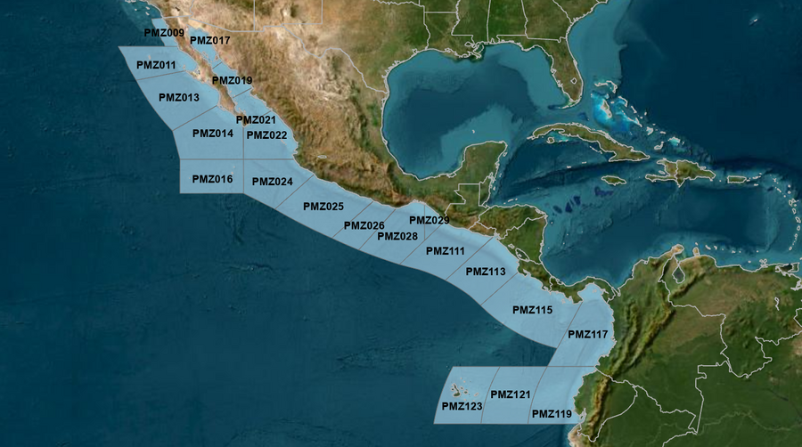
East Pacific within 250 nm of Mexico (OFFPZ7)
000
FZPN27 KNHC 110147
OFFPZ7

Offshore Waters Forecast
NWS National Hurricane Center Miami, FL
647 PM PDT Fri May 10 2024

Offshore Waters Forecast for the E Pacific within 250 nm of
Mexico

Seas given as significant wave height, which is the average
height of the highest 1/3 of the waves. Individual waves may be
more than twice the significant wave height.
Synopsis for the E Pacific within 250 nm of Mexico
PMZ001-111400-
Synopsis for the E Pacific within 250 nm of Mexico
647 PM PDT Fri May 10 2024

.SYNOPSIS...Gentle to moderate northwesterly winds will prevail
off the Baja California waters through early next week, with
small areas of fresh winds developing along the coast during the
late afternoon and evening hours through Sat. Northwest swell
will maintain seas to 8 ft through early Sat before gradually
subsiding to 6 ft or less through early next week. Gentle to
locally moderate winds and moderate seas are expected elsewhere
across the open offshore waters of Mexico through the middle of
next week.
PMZ009 Zone Forecast
PMZ009-111400-
Mexico Border S to 30N within 60 nm of shore-
647 PM PDT Fri May 10 2024

.TONIGHT...NW winds 10 to 15 kt. Seas 4 to 6 ft. Period
12 seconds.
.SAT...NW winds 10 to 15 kt. Seas 3 to 5 ft. Period 13 seconds.
.SAT NIGHT...W to NW winds 10 to 15 kt. Seas 3 to 5 ft. Period
17 seconds.
.SUN...NW winds 10 to 15 kt. Seas 3 to 5 ft. Period 17 seconds.
.SUN NIGHT...NW winds 10 to 15 kt. Seas 2 to 4 ft. Period
15 seconds.
.MON...W to NW winds 10 kt. Seas 2 to 4 ft. Period 16 seconds.
.MON NIGHT...NW winds 10 kt. Seas 2 to 4 ft. Period 15 seconds.
.TUE...NW winds 10 to 15 kt. Seas 3 to 5 ft. Period 14 seconds.
.TUE NIGHT...NW winds 10 to 15 kt. Seas 3 to 5 ft. Period
14 seconds.
.WED...NW winds 10 to 15 kt. Seas 4 to 6 ft. Period 13 seconds.
.WED NIGHT...NW winds 10 to 15 kt. Seas 4 to 6 ft. Period
13 seconds.
Forecaster AL
PMZ011 Zone Forecast
PMZ011-111400-
30N to Punta Eugenia within 250 nm of shore-
647 PM PDT Fri May 10 2024

.TONIGHT...NW winds 10 to 15 kt. Seas 5 to 7 ft in NW swell.
Period 11 seconds.
.SAT...NW winds 10 to 15 kt. Seas 4 to 6 ft. Period 12 seconds.
.SAT NIGHT...NW winds 10 to 15 kt. Seas 4 to 6 ft. Period
12 seconds.
.SUN...NW winds 10 to 15 kt. Seas 4 to 6 ft. Period 12 seconds.
.SUN NIGHT...NW winds 10 to 15 kt. Seas 3 to 5 ft. Period
13 seconds.
.MON...W to NW winds 10 to 15 kt. Seas 3 to 5 ft. Period
15 seconds.
.MON NIGHT...NW winds 10 to 15 kt. Seas 2 to 4 ft. Period
15 seconds.
.TUE...NW winds 10 to 15 kt. Seas 3 to 5 ft. Period 14 seconds.
.TUE NIGHT...NW winds 10 to 15 kt. Seas 5 to 7 ft in NW swell.
Period 13 seconds.
.WED...NW winds 10 to 15 kt. Seas 5 to 7 ft in NW swell. Period
13 seconds.
.WED NIGHT...NW winds 15 kt. Seas 5 to 7 ft in NW swell. Period
12 seconds.
Forecaster AL
PMZ013 Zone Forecast
PMZ013-111400-
Punta Eugenia to Cabo San Lazaro within 250 nm offshore-
647 PM PDT Fri May 10 2024

.TONIGHT...NW to N winds 15 to 20 kt. Seas 5 to 7 ft. Period
12 seconds.
.SAT...NW to N winds 15 to 20 kt. Seas 5 to 7 ft. Period
12 seconds.
.SAT NIGHT...NW to N winds 15 to 20 kt. Seas 5 to 7 ft. Period
15 seconds.
.SUN...NW winds 10 to 15 kt. Seas 4 to 6 ft. Period 17 seconds.
.SUN NIGHT...NW winds 10 to 15 kt. Seas 4 to 6 ft. Period
13 seconds.
.MON...NW winds 10 to 15 kt. Seas 3 to 5 ft. Period 13 seconds.
.MON NIGHT...NW winds 10 to 15 kt. Seas 3 to 5 ft. Period
15 seconds.
.TUE...NW winds 10 to 15 kt. Seas 3 to 5 ft. Period 14 seconds.
.TUE NIGHT...NW winds 15 kt. Seas 3 to 5 ft. Period 14 seconds.
.WED...NW to N winds 10 to 15 kt. Seas 4 to 6 ft. Period
14 seconds.
.WED NIGHT...NW winds 10 to 15 kt. Seas 4 to 6 ft. Period
13 seconds.
Forecaster AL
PMZ014 Zone Forecast
PMZ014-111400-
Cabo San Lazaro to Cabo San Lucas within 350 nm offshore N of
20N-
647 PM PDT Fri May 10 2024

.TONIGHT...NW to N winds 15 to 20 kt. Seas 6 to 8 ft. Period
13 seconds.
.SAT...NW to N winds 15 to 20 kt. Seas 5 to 7 ft. Period
12 seconds.
.SAT NIGHT...NW to N winds 10 to 15 kt. Seas 5 to 7 ft in NW
swell. Period 17 seconds.
.SUN...NW to N winds 10 to 15 kt. Seas 5 to 7 ft in NW swell.
Period 16 seconds.
.SUN NIGHT...NW to N winds 10 to 15 kt. Seas 4 to 6 ft. Period
13 seconds.
.MON...NW to N winds 10 to 15 kt. Seas 4 to 6 ft. Period
13 seconds.
.MON NIGHT...NW to N winds 10 to 15 kt. Seas 4 to 6 ft. Period
14 seconds.
.TUE...NW to N winds 10 to 15 kt. Seas 4 to 6 ft. Period
14 seconds.
.TUE NIGHT...NW to N winds 15 to 20 kt. Seas 4 to 6 ft. Period
13 seconds.
.WED...NW to N winds 10 to 15 kt. Seas 5 to 7 ft in SW swell.
Period 13 seconds.
.WED NIGHT...NW to N winds 10 to 15 kt. Seas 5 to 7 ft in W to
NW swell. Period 13 seconds.
Forecaster AL
PMZ016 Zone Forecast
PMZ016-111400-
From 17N to 20N Between 110W and 115W including the
Revillagigedo Islands-
647 PM PDT Fri May 10 2024

.TONIGHT...N winds 15 to 20 kt. Seas 6 to 8 ft. Period
13 seconds.
.SAT...N winds 10 to 15 kt. Seas 5 to 7 ft in NW to N swell.
Period 13 seconds.
.SAT NIGHT...N winds 10 to 15 kt. Seas 5 to 7 ft in NW to N
swell. Period 12 seconds.
.SUN...N winds 10 to 15 kt. Seas 5 to 7 ft in NW to N swell.
Period 12 seconds.
.SUN NIGHT...N winds 10 to 15 kt. Seas 4 to 6 ft. Period
13 seconds.
.MON...N winds 10 to 15 kt. Seas 4 to 6 ft. Period 12 seconds.
.MON NIGHT...N winds 10 to 15 kt. Seas 4 to 6 ft. Period
13 seconds.
.TUE...N winds 10 to 15 kt. Seas 4 to 6 ft. Period 13 seconds.
.TUE NIGHT...N winds 10 to 15 kt. Seas 4 to 6 ft. Period
13 seconds.
.WED...N winds 15 kt. Seas 4 to 6 ft. Period 13 seconds.
.WED NIGHT...NW to N winds 10 to 15 kt. Seas 4 to 6 ft. Period
14 seconds.
Forecaster AL
PMZ017 Zone Forecast
PMZ017-111400-
Northern Gulf of California-
647 PM PDT Fri May 10 2024

.TONIGHT...N of 30N, variable winds less than 5 kt, becoming SW
10 kt. Elsewhere, N to NE winds 10 kt, shifting to SW to W. Seas
3 ft or less. Period 4 seconds.
.SAT...Variable winds less than 5 kt, becoming NW 10 kt in the
afternoon. Seas 3 ft or less. Period 4 seconds.
.SAT NIGHT...SW to W winds 10 kt. Seas 3 ft or less. Period
3 seconds.
.SUN...S winds 10 kt. Seas 3 ft or less. Period 3 seconds.
.SUN NIGHT...S to SW winds 10 kt. Seas 3 ft or less. Period
1 second.
.MON...SE to S winds 10 kt. Seas 3 ft or less. Period 2 seconds.
.MON NIGHT...S to SW winds 10 to 15 kt. Seas 3 ft or less.
Period 2 seconds.
.TUE...S winds 10 to 15 kt. Seas 3 ft or less. Period 2 seconds.
.TUE NIGHT...S to SW winds 10 to 15 kt. Seas 2 to 4 ft. Period
3 seconds.
.WED...S winds 10 to 15 kt. Seas 2 to 4 ft. Period 4 seconds.
.WED NIGHT...S winds 10 to 15 kt. Seas 3 ft or less. Period
2 seconds.
Forecaster AL
PMZ019 Zone Forecast
PMZ019-111400-
Central Gulf of California-
647 PM PDT Fri May 10 2024

.TONIGHT...W to NW winds 10 kt. Seas 3 ft or less. Period
11 seconds.
.SAT...NW winds 10 kt. Seas 3 ft or less. Period 10 seconds.
.SAT NIGHT...W to NW winds 10 kt. Seas 3 ft or less. Period
10 seconds.
.SUN...NW winds 10 kt, shifting to SW to W in the afternoon.
Seas 3 ft or less. Period 10 seconds.
.SUN NIGHT...S to SW winds 10 kt. Seas 3 ft or less. Period
10 seconds.
.MON...SE to S winds 10 kt. Seas 3 ft or less. Period
10 seconds.
.MON NIGHT...SW winds 10 kt. Seas 3 ft or less. Period
11 seconds.
.TUE...W winds 10 kt. Seas 3 ft or less. Period 12 seconds.
.TUE NIGHT...SW to W winds 10 to 15 kt. Seas 2 to 4 ft. Period
12 seconds.
.WED...W to NW winds 10 to 15 kt. Seas 2 to 4 ft. Period
11 seconds.
.WED NIGHT...W winds 10 kt. Seas 3 ft or less. Period
11 seconds.
Forecaster AL
PMZ021 Zone Forecast
PMZ021-111400-
Southern Gulf of California-
647 PM PDT Fri May 10 2024

.TONIGHT...NW winds 10 to 15 kt. Seas 2 to 4 ft. Period
13 seconds.
.SAT...NW winds 10 kt. Seas 2 to 4 ft. Period 18 seconds.
.SAT NIGHT...SW to W winds 10 kt. Seas 2 to 4 ft. Period
18 seconds.
.SUN...Variable winds less than 5 kt, becoming S 10 kt in the
afternoon. Seas 3 ft or less. Period 17 seconds.
.SUN NIGHT...S winds 10 kt. Seas 3 ft or less. Period
13 seconds.
.MON...S winds 10 kt. Seas 3 ft or less. Period 13 seconds.
.MON NIGHT...W winds 10 kt. Seas 3 ft or less. Period
12 seconds.
.TUE...W to NW winds 10 kt. Seas 3 ft or less. Period
12 seconds.
.TUE NIGHT...W winds 10 to 15 kt. Seas 3 ft or less. Period
12 seconds.
.WED...W to NW winds 10 to 15 kt. Seas 2 to 4 ft. Period
12 seconds.
.WED NIGHT...W winds 10 to 15 kt. Seas 2 to 4 ft. Period
12 seconds.
Forecaster AL
PMZ022 Zone Forecast
PMZ022-111400-
N of 20N E of 110W to the Entrance of the Gulf of California-
647 PM PDT Fri May 10 2024

.TONIGHT...W to NW winds 10 to 15 kt. Seas 5 to 7 ft in SW to W
swell. Period 14 seconds.
.SAT...W winds 10 kt. Seas 5 to 7 ft in SW to W swell. Period
18 seconds.
.SAT NIGHT...SW to W winds 10 to 15 kt. Seas 4 to 6 ft. Period
18 seconds.
.SUN...SW winds 10 kt. Seas 4 to 6 ft in SW swell. Period
17 seconds.
.SUN NIGHT...SW to W winds 10 to 15 kt. Seas 4 to 6 ft. Period
15 seconds.
.MON...SW to W winds 10 to 15 kt. Seas 4 to 6 ft. Period
15 seconds.
.MON NIGHT...NW winds 10 to 15 kt. Seas 4 to 6 ft. Period
14 seconds.
.TUE...NW winds 10 to 15 kt. Seas 4 to 6 ft. Period 14 seconds.
.TUE NIGHT...NW winds 15 to 20 kt. Seas 5 to 7 ft. Period
14 seconds.
.WED...NW winds 10 to 15 kt. Seas 5 to 7 ft in SW to W swell.
Period 13 seconds.
.WED NIGHT...NW winds 15 to 20 kt. Seas 5 to 7 ft. Period
13 seconds.
Forecaster AL
PMZ024 Zone Forecast
PMZ024-111400-
Colima and Jalisco within 300 nm offshore S of 20N and E of
110W-
647 PM PDT Fri May 10 2024

.TONIGHT...NW to N winds 10 to 15 kt. Seas 5 to 7 ft in NW
swell. Period 14 seconds.
.SAT...N winds 10 kt. Seas 5 to 7 ft in NW swell. Period
17 seconds.
.SAT NIGHT...N winds 10 kt. Seas 5 to 7 ft in NW swell. Period
17 seconds.
.SUN...NE to E winds 10 kt, shifting to W to NW in the
afternoon. Seas 4 to 6 ft in NW swell. Period 16 seconds.
.SUN NIGHT...NW winds 10 kt. Seas 4 to 6 ft in W to NW swell.
Period 15 seconds.
.MON...NW winds 10 kt. Seas 3 to 5 ft. Period 14 seconds.
.MON NIGHT...NW winds 10 to 15 kt. Seas 4 to 6 ft. Period
14 seconds.
.TUE...NW to N winds 10 to 15 kt. Seas 4 to 6 ft. Period
13 seconds.
.TUE NIGHT...NW winds 10 to 15 kt. Seas 4 to 6 ft. Period
13 seconds.
.WED...NW to N winds 10 to 15 kt. Seas 4 to 6 ft. Period
13 seconds.
.WED NIGHT...NW winds 10 to 15 kt. Seas 4 to 6 ft. Period
13 seconds.
Forecaster AL
PMZ025 Zone Forecast
PMZ025-111400-
Michoacan and Guerrero within 250 nm offshore-
647 PM PDT Fri May 10 2024

.TONIGHT...W winds 10 kt, becoming variable winds less than
5 kt. Seas 4 to 6 ft in W swell. Period 16 seconds.
.SAT...Within 60 nm of shore, NE to E winds 10 kt, shifting to
SW in the afternoon. Elsewhere, variable winds less than 5 kt.
Seas 4 to 6 ft in W swell. Period 18 seconds.
.SAT NIGHT...Variable winds less than 5 kt. Seas 4 to 6 ft in W
swell. Period 17 seconds.
.SUN...W winds 10 kt Within 60 nm of shore, and variable less
than 5 kt Elsewhere. Seas 4 to 6 ft in SW to W swell. Period
17 seconds.
.SUN NIGHT...W winds 10 kt. Seas 4 to 6 ft in SW to W swell.
Period 15 seconds.
.MON...W to NW winds 10 kt. Seas 4 to 6 ft in SW swell. Period
14 seconds.
.MON NIGHT...W to NW winds 10 kt. Seas 3 to 5 ft. Period
14 seconds.
.TUE...NW winds 10 kt. Seas 4 to 6 ft in S to SW swell. Period
14 seconds.
.TUE NIGHT...W to NW winds 10 to 15 kt. Seas 4 to 6 ft. Period
13 seconds.
.WED...NW winds 10 kt. Seas 4 to 6 ft in S to SW swell. Period
13 seconds.
.WED NIGHT...W to NW winds 10 kt. Seas 4 to 6 ft in S to SW
swell. Period 12 seconds.
Forecaster AL
PMZ026 Zone Forecast
PMZ026-111400-
Oaxaca W of Puerto Angel within 250 nm offshore-
647 PM PDT Fri May 10 2024

.TONIGHT...SW to W winds 10 kt, shifting to NW late.
Seas 3 to 5 ft. Period 16 seconds.
.SAT...NW to N winds 10 kt. Seas 4 to 6 ft in S to SW swell.
Period 18 seconds.
.SAT NIGHT...Variable winds less than 5 kt. Seas 4 to 6 ft in SW
swell. Period 17 seconds.
.SUN...W to NW winds 10 kt N of 14N, and variable less than 5 kt
S of 14N. Seas 4 to 6 ft in S to SW swell. Period 17 seconds.
.SUN NIGHT...W to NW winds 10 kt N of 14N, and variable less
than 5 kt S of 14N. Seas 4 to 6 ft in SW swell. Period
15 seconds.
.MON...NW winds 10 kt. Seas 3 to 5 ft. Period 14 seconds.
.MON NIGHT...W to NW winds 10 kt N of 14N, and variable less
than 5 kt S of 14N. Seas 3 to 5 ft. Period 14 seconds.
.TUE...NW winds 10 kt. Seas 3 to 5 ft. Period 14 seconds.
.TUE NIGHT...NW winds 10 kt. Seas 3 to 5 ft. Period 13 seconds.
.WED...NW to N winds 10 kt. Seas 3 to 5 ft. Period 13 seconds.
.WED NIGHT...Variable winds less than 5 kt. Seas 3 to 5 ft in SW
swell. Period 13 seconds.
Forecaster AL
PMZ028 Zone Forecast
PMZ028-111400-
Oaxaca E of Puerto Angel within 300 nm offshore including the
Gulf of Tehuantepec-
647 PM PDT Fri May 10 2024

.TONIGHT...SW to W winds 10 kt N of 14N, and variable less than
5 kt S of 14N. Seas 3 to 5 ft in S to SW swell. Period
17 seconds.
.SAT...NW to N winds 10 kt in the morning, becoming variable
winds less than 5 kt. Seas 3 to 5 ft in S to SW swell. Period
18 seconds.
.SAT NIGHT...SE winds 10 kt in the evening, becoming variable
winds less than 5 kt. Seas 3 to 5 ft in S to SW swell. Period
17 seconds. Scattered showers and isolated tstms through the
night.
.SUN...Variable winds less than 5 kt, becoming SE to S 10 kt in
the afternoon. Seas 3 to 5 ft. Period 17 seconds. Scattered
showers and isolated tstms through the day.
.SUN NIGHT...W winds 10 to 15 kt N of 14N, and variable less
than 5 kt S of 14N. Seas 3 to 5 ft. Period 15 seconds.
.MON...SW winds 10 to 15 kt N of 14N, and variable less than
5 kt S of 14N. Seas 3 to 5 ft. Period 14 seconds.
.MON NIGHT...SW to W winds 10 to 15 kt N of 14N, and variable
less than 5 kt S of 14N. Seas 3 to 5 ft. Period 14 seconds.
.TUE...NW to N winds 10 kt. Seas 4 to 6 ft in S to SW swell.
Period 14 seconds.
.TUE NIGHT...SE winds 10 kt. Seas 3 to 5 ft. Period 13 seconds.
.WED...NE to E winds 10 kt. Seas 3 to 5 ft. Period 13 seconds.
.WED NIGHT...E to SE winds 10 kt. Seas 3 to 5 ft. Period
13 seconds.
Forecaster AL
PMZ029 Zone Forecast
PMZ029-111400-
Offshore Chiapas E of 94W-
647 PM PDT Fri May 10 2024

.TONIGHT...SW winds 10 kt, becoming variable winds less than
5 kt. Seas 2 to 4 ft. Period 15 seconds.
.SAT...Variable winds less than 5 kt, becoming W 10 kt in the
afternoon. Seas 3 to 5 ft. Period 18 seconds.
.SAT NIGHT...Variable winds less than 5 kt. Seas 3 to 5 ft in SW
swell. Period 18 seconds.
.SUN...Variable winds less than 5 kt. Seas 3 to 5 ft in SW
swell. Period 17 seconds.
.SUN NIGHT...Variable winds less than 5 kt. Seas 3 to 5 ft in SW
swell. Period 15 seconds.
.MON...Variable winds less than 5 kt. Seas 3 to 5 ft in S to SW
swell. Period 15 seconds.
.MON NIGHT...Variable winds less than 5 kt. Seas 3 to 5 ft in S
to SW swell. Period 15 seconds.
.TUE...W winds 10 kt E of 93W, and variable less than 5 kt W of
93W. Seas 3 to 5 ft in S to SW swell. Period 14 seconds.
.TUE NIGHT...Variable winds less than 5 kt. Seas 3 to 5 ft in SW
swell. Period 14 seconds.
.WED...E to SE winds 10 kt. Seas 3 to 5 ft. Period 13 seconds.
.WED NIGHT...SE winds 10 kt. Seas 3 to 5 ft. Period 13 seconds.
Forecaster AL
East Pacific offshore of Central America, Colombia, & Ecuador (OFFPZ8)
000
FZPN28 KNHC 110148
OFFPZ8

Offshore Waters Forecast
NWS National Hurricane Center Miami, FL
648 PM PDT Fri May 10 2024

Offshore Waters Forecast for the E Pacific within 250 nm of
Central America, Colombia, and within 750 nm of Ecuador

Seas given as significant wave height, which is the average
height of the highest 1/3 of the waves. Individual waves may be
more than twice the significant wave height.
Synopsis for the E Pacific within 250 nm of Central America, Colombia, and within 750 nm of Ecuador
PMZ101-111400-
Synopsis for the E Pacific within 250 nm of Central America,
Colombia, and within 750 nm of Ecuador
648 PM PDT Fri May 10 2024

.SYNOPSIS...Gentle to moderate S to SW winds south of the
monsoon trough are expected through early next week. Southerly
swell moving through the regional waters will build seas to 6 to
7 ft S of the Galapagos Islands through Sun. Elsewhere, light to
gentle winds will prevail with moderate seas of 6 ft or less.
PMZ111 Zone Forecast
PMZ111-111400-
Guatemala and El Salvador to 250 nm offshore-
648 PM PDT Fri May 10 2024

.TONIGHT...Variable winds less than 5 kt. Seas 3 to 5 ft in S to
SW swell. Period 16 seconds.
.SAT...Variable winds less than 5 kt, becoming E 10 kt in the
afternoon. Seas 3 to 5 ft. Period 18 seconds. Scattered showers
and isolated tstms through the day.
.SAT NIGHT...Variable winds less than 5 kt. Seas 3 to 5 ft in S
to SW swell. Period 18 seconds.
.SUN...E to SE winds 10 kt. Seas 3 to 5 ft. Period 17 seconds.
Scattered showers and isolated tstms through the day.
.SUN NIGHT...Variable winds less than 5 kt. Seas 3 to 5 ft in S
to SW swell. Period 15 seconds.
.MON...E winds 10 kt. Seas 3 to 5 ft. Period 14 seconds.
.MON NIGHT...Variable winds less than 5 kt. Seas 3 to 5 ft in S
to SW swell. Period 14 seconds.
.TUE...E winds 10 kt. Seas 3 to 5 ft. Period 14 seconds.
.TUE NIGHT...SE to S winds 10 kt. Seas 3 to 5 ft. Period
14 seconds.
.WED...E to SE winds 10 to 15 kt. Seas 3 to 5 ft. Period
13 seconds.
.WED NIGHT...SE to S winds 10 to 15 kt. Seas 3 to 5 ft. Period
13 seconds.
Forecaster AL
PMZ113 Zone Forecast
PMZ113-111400-
El Salvador to North Costa Rica including the Gulfs of Fonseca
and Papagayo-
648 PM PDT Fri May 10 2024

.TONIGHT...Offshore Gulf of Papagayo, S winds 10 to 15 kt,
becoming variable winds less than 5 kt. Elsewhere, SW winds
10 to 15 kt. Seas 4 to 6 ft. Period 16 seconds. Scattered
showers and isolated tstms.
.SAT...E to SE winds 10 kt. Seas 4 to 6 ft in S swell. Period
18 seconds. Scattered tstms through the day.
.SAT NIGHT...S winds 10 kt in the evening, becoming variable
winds less than 5 kt. Seas 3 to 5 ft in S swell. Period
17 seconds. Scattered showers and isolated tstms through the
night.
.SUN...SE winds 10 kt. Seas 3 to 5 ft. Period 17 seconds.
Scattered showers and isolated tstms through the day.
.SUN NIGHT...S to SW winds 10 kt. Seas 3 to 5 ft. Period
15 seconds.
.MON...S to SW winds 10 kt. Seas 3 to 5 ft. Period 14 seconds.
.MON NIGHT...SW winds 10 kt. Seas 3 to 5 ft. Period 14 seconds.
.TUE...SE to S winds 10 to 15 kt. Seas 4 to 6 ft. Period
14 seconds.
.TUE NIGHT...S to SW winds 10 kt. Seas 4 to 6 ft in S swell.
Period 14 seconds.
.WED...S to SW winds 10 kt. Seas 4 to 6 ft in S swell. Period
13 seconds.
.WED NIGHT...S to SW winds 10 to 15 kt. Seas 4 to 6 ft. Period
13 seconds.
Forecaster AL
PMZ115 Zone Forecast
PMZ115-111400-
North Costa Rica to West Panama to 250 nm offshore-
648 PM PDT Fri May 10 2024

.TONIGHT...SW to W winds 10 to 15 kt. Seas 4 to 6 ft. Period
14 seconds. Numerous showers and scattered tstms.
.SAT...SW to W winds 10 kt. Seas 4 to 6 ft in S swell. Period
16 seconds. Scattered tstms.
.SAT NIGHT...W to NW winds 10 kt. Seas 4 to 6 ft in S swell.
Period 17 seconds. Scattered showers and isolated tstms through
the night.
.SUN...Near the Azuero Peninsula, E winds 10 kt in the morning,
becoming variable winds less than 5 kt. Elsewhere, S winds
10 kt. Seas 4 to 6 ft in S swell. Period 16 seconds. Scattered
showers and isolated tstms through the day.
.SUN NIGHT...Variable winds less than 5 kt Near the Azuero
Peninsula, and SW 10 kt Elsewhere. Seas 4 to 6 ft in S swell.
Period 14 seconds.
.MON...Variable winds less than 5 kt Near the Azuero Peninsula,
and SW to W 10 kt Elsewhere. Seas 4 to 6 ft in S swell. Period
14 seconds.
.MON NIGHT...SW to W winds 10 kt. Seas 3 to 5 ft. Period
14 seconds.
.TUE...SW winds 10 to 15 kt. Seas 4 to 6 ft. Period 14 seconds.
.TUE NIGHT...SW to W winds 10 to 15 kt. Seas 4 to 6 ft. Period
13 seconds.
.WED...SW winds 10 to 15 kt. Seas 4 to 6 ft. Period 13 seconds.
.WED NIGHT...SW winds 10 to 15 kt. Seas 4 to 6 ft. Period
12 seconds.
Forecaster AL
PMZ117 Zone Forecast
PMZ117-111400-
East Panama and Colombia including the Gulf of Panama-
648 PM PDT Fri May 10 2024

.TONIGHT...SW to W winds 10 to 15 kt. Seas 4 to 6 ft. Period
15 seconds. Scattered showers and isolated tstms through the
night.
.SAT...SW to W winds 10 kt. Seas 4 to 6 ft in S to SW swell.
Period 18 seconds. Scattered showers and isolated tstms through
the day.
.SAT NIGHT...Gulf of Panama, variable winds less than 5 kt.
Elsewhere, variable winds less than 5 kt, becoming SW 10 kt
late. Seas 4 to 6 ft in S to SW swell. Period
18 seconds. Scattered showers and isolated tstms through the
night.
.SUN...Gulf of Panama, variable winds less than 5 kt. Elsewhere,
SE to S winds 10 kt, shifting to SW to W in the afternoon. Seas
4 to 6 ft in S to SW swell. Period 17 seconds. Scattered showers
and isolated tstms through the day.
.SUN NIGHT...Variable winds less than 5 kt Gulf of Panama, and
SW to W 10 kt Elsewhere. Seas 4 to 6 ft in S to SW swell. Period
16 seconds.
.MON...W winds 10 to 15 kt. Seas 4 to 6 ft. Period 15 seconds.
.MON NIGHT...SW to W winds 10 to 15 kt. Seas 3 to 5 ft. Period
14 seconds.
.TUE...SW winds 10 to 15 kt. Seas 4 to 6 ft. Period 14 seconds.
.TUE NIGHT...SW winds 10 to 15 kt. Seas 4 to 6 ft. Period
14 seconds.
.WED...SW winds 10 to 15 kt. Seas 4 to 6 ft. Period 13 seconds.
.WED NIGHT...SW winds 10 to 15 kt. Seas 4 to 6 ft. Period
13 seconds.
Forecaster AL
PMZ119 Zone Forecast
PMZ119-111400-
Ecuador including the Gulf of Guayaquil to 250 nm offshore-
648 PM PDT Fri May 10 2024

.TONIGHT...S to SW winds 10 to 15 kt. Seas 5 to 7 ft in S to SW
swell. Period 15 seconds.
.SAT...SW winds 10 kt. Seas 5 to 7 ft in S to SW swell. Period
17 seconds.
.SAT NIGHT...SW winds 10 to 15 kt. Seas 5 to 7 ft in S to SW
swell. Period 17 seconds.
.SUN...S to SW winds 10 to 15 kt. Seas 4 to 6 ft. Period
16 seconds.
.SUN NIGHT...S to SW winds 10 kt. Seas 4 to 6 ft in S to SW
swell. Period 15 seconds.
.MON...S to SW winds 10 to 15 kt. Seas 4 to 6 ft. Period
14 seconds.
.MON NIGHT...S to SW winds 10 to 15 kt. Seas 4 to 6 ft. Period
14 seconds.
.TUE...S to SW winds 10 to 15 kt. Seas 4 to 6 ft. Period
13 seconds.
.TUE NIGHT...S to SW winds 10 to 15 kt. Seas 4 to 6 ft. Period
12 seconds.
.WED...S to SW winds 10 to 15 kt. Seas 4 to 6 ft. Period
12 seconds.
.WED NIGHT...S to SW winds 10 kt. Seas 4 to 6 ft in S swell.
Period 11 seconds.
Forecaster AL
PMZ121 Zone Forecast
PMZ121-111400-
Ecuador between 250 and 500 nm offshore-
648 PM PDT Fri May 10 2024

.TONIGHT...SE to S winds 10 to 15 kt. Seas 5 to 7 ft in S swell.
Period 17 seconds.
.SAT...S winds 10 kt. Seas 5 to 7 ft in S swell. Period
17 seconds.
.SAT NIGHT...SE to S winds 10 to 15 kt. Seas 5 to 7 ft in S
swell. Period 16 seconds.
.SUN...SE to S winds 10 to 15 kt. Seas 5 to 7 ft in S swell.
Period 15 seconds.
.SUN NIGHT...SE to S winds 10 kt. Seas 4 to 6 ft in S swell.
Period 14 seconds.
.MON...S winds 10 to 15 kt. Seas 4 to 6 ft. Period 14 seconds.
.MON NIGHT...SE to S winds 10 kt. Seas 4 to 6 ft in S swell.
Period 13 seconds.
.TUE...SE to S winds 10 kt. Seas 4 to 6 ft in S swell. Period
13 seconds.
.TUE NIGHT...S winds 10 to 15 kt. Seas 4 to 6 ft. Period
11 seconds.
.WED...SE to S winds 10 to 15 kt. Seas 4 to 6 ft. Period
11 seconds.
.WED NIGHT...SE to S winds 10 kt. Seas 4 to 6 ft in S swell.
Period 10 seconds.
Forecaster AL
PMZ123 Zone Forecast
PMZ123-111400-
Offshore Galapagos Islands-
648 PM PDT Fri May 10 2024

.TONIGHT...SE winds 10 to 15 kt. Seas 5 to 7 ft in S swell.
Period 17 seconds.
.SAT...SE winds 10 to 15 kt. Seas 5 to 7 ft in S swell. Period
17 seconds.
.SAT NIGHT...SE winds 10 to 15 kt. Seas 5 to 7 ft in S swell.
Period 16 seconds.
.SUN...SE winds 10 kt. Seas 5 to 7 ft in S swell. Period
15 seconds.
.SUN NIGHT...SE winds 10 kt. Seas 5 to 7 ft in S swell. Period
12 seconds.
.MON...SE to S winds 10 kt. Seas 4 to 6 ft in S swell. Period
12 seconds.
.MON NIGHT...SE to S winds 10 kt. Seas 4 to 6 ft in S swell.
Period 12 seconds.
.TUE...SE to S winds 10 kt. Seas 4 to 6 ft in S swell. Period
11 seconds.
.TUE NIGHT...S winds 10 kt. Seas 4 to 6 ft in S swell. Period
11 seconds.
.WED...SE to S winds 10 kt. Seas 4 to 6 ft in S swell. Period
11 seconds.
.WED NIGHT...SE winds 10 kt. Seas 4 to 6 ft in S swell. Period
11 seconds.
Forecaster AL
Tropical North Atlantic High Seas (HSFAT2)
757
FZNT02 KNHC 110338
HSFAT2

HIGH SEAS FORECAST
NWS NATIONAL HURRICANE CENTER MIAMI FL
0430 UTC SAT MAY 11 2024

SUPERSEDED BY NEXT ISSUANCE IN 6 HOURS

SEAS GIVEN AS SIGNIFICANT WAVE HEIGHT...WHICH IS THE AVERAGE
HEIGHT OF THE HIGHEST 1/3 OF THE WAVES. INDIVIDUAL WAVES MAY BE
MORE THAN TWICE THE SIGNIFICANT WAVE HEIGHT.

SECURITE

ATLANTIC FROM 07N TO 31N W OF 35W INCLUDING CARIBBEAN SEA AND
GULF OF MEXICO

SYNOPSIS VALID 0000 UTC SAT MAY 11.
24 HOUR FORECAST VALID 0000 UTC SUN MAY 12.
48 HOUR FORECAST VALID 0000 UTC MON MAY 13.

.WARNINGS.

.NONE.

.SYNOPSIS AND FORECAST.

.ATLC COLD FRONT OVER THE SE U.S. WITHIN 31N68W TO 31N73W TO
31N80W TO 31N79W TO 30N73W TO 30N72W TO 31N68W SW TO W WINDS 20
TO 25 KT. SEAS LESS THAN 8 FT.
.18 HOUR FORECAST COLD FRONT FROM 31N71W TO 27N80W. WITHIN
31N64W TO 31N70W TO 30N67W TO 30N66W TO 31N64W SW WINDS 20 TO 25
KT. SEAS 8 TO 9 FT.
.24 HOUR FORECAST WEAKENING COLD FRONT FROM 31N69W TO 28N73W TO
26N80W. WITHIN 31N64W TO 31N69W TO 30N68W TO 30N67W TO 31N64W
WINDS 20 KT OR LESS. SEAS TO 8 FT IN DECAYING W SWELL.
.36 HOUR FORECAST WEAKENING COLD FRONT FROM 31N65W TO 27N69W
TO 25N78W. WINDS 20 KT OR LESS. SEAS LESS THAN 8 FT.

.CARIBBEAN WITHIN 17N84W TO 17N86W TO 16N86W TO 16N85W TO 15N84W
TO 17N84W E WINDS 20 TO 25 KT. SEAS LESS THAN 8 FT.
.24 HOUR FORECAST LITTLE CHANGE.
.48 HOUR FORECAST LITTLE CHANGE...EXCEPT E WINDS 20 TO 30 KT.
SEAS LESS THAN 8 FT.

.GULF OF MEXICO 24 HOUR FORECAST WITHIN 22N87W TO 23N90W TO
22N91W TO 21N90W TO 21N89W TO 22N87W NE TO E WINDS 20 TO 25 KT.
SEAS LESS THAN 8 FT.
.30 HOUR FORECAST WINDS 20 KT OR LESS. SEAS LESS THAN 8 FT.
.48 HOUR FORECAST WITHIN 22N87W TO 23N90W TO 22N90W TO 21N90W TO
21N89W TO 22N87W E WINDS 20 TO 25 KT. SEAS LESS THAN 8 FT.

.REMAINDER OF AREA WINDS 20 KT OR LESS. SEAS LESS THAN 8 FT.

$$
.FORECASTER AGUIRRE. NATIONAL HURRICANE CENTER.
Tropical Northeast Pacific High Seas (HSFEP2)
000
FZPN03 KNHC 110230
HSFEP2

HIGH SEAS FORECAST
NWS NATIONAL HURRICANE CENTER MIAMI FL
0430 UTC SAT MAY 11 2024

SUPERSEDED BY NEXT ISSUANCE IN 6 HOURS

SEAS GIVEN AS SIGNIFICANT WAVE HEIGHT...WHICH IS THE AVERAGE
HEIGHT OF THE HIGHEST 1/3 OF THE WAVES. INDIVIDUAL WAVES MAY BE
MORE THAN TWICE THE SIGNIFICANT WAVE HEIGHT.

SECURITE

E PACIFIC FROM THE EQUATOR TO 30N E OF 140W AND 03.4S TO THE
EQUATOR E OF 120W

SYNOPSIS VALID 0000 UTC SAT MAY 11.
24 HOUR FORECAST VALID 0000 UTC SUN MAY 12.
48 HOUR FORECAST VALID 0000 UTC MON MAY 13.

.WARNINGS.

.NONE.

.SYNOPSIS AND FORECAST.

.WITHIN 20N111W TO 22N112W TO 22N113W TO 20N115W TO 18N115W TO
18N113W TO 20N111W WINDS 20 KT OR LESS. SEAS 8 FT IN NW SWELL.
.12 HOUR FORECAST CONDITIONS IMPROVE. WINDS 20 KT OR LESS. SEAS
8 FT.

.WITHIN 13N135W TO 13N137W TO 14N140W TO 10N140W TO 11N135W TO
13N135W WINDS 20 KT OR LESS. SEAS 8 FT IN MIXED NW AND NE
SWELL.
.24 HOUR FORECAST CONDITIONS IMPROVE. WINDS 20 KT OR LESS. SEAS
LESS THAN 8 FT.

.REMAINDER OF AREA WINDS 20 KT OR LESS. SEAS LESS THAN 8 FT.

CONVECTION VALID AT 0230 UTC SAT MAY 11...

.INTERTROPICAL CONVERGENCE ZONE/MONSOON TROUGH...
MONSOON TROUGH FROM 10N86W TO 10N100W TO 06.5N110W. ITCZ FROM
06.5N110W TO 08N140W. SCATTERED MODERATE ISOLATED STRONG FROM
05N TO 13N BETWEEN 86W AND 106W.

$$
.FORECASTER AL. NATIONAL HURRICANE CENTER.