NHC Graphical Outlook Archive
« Earliest Available ‹ Earlier Later › Latest Available »
Place your mouse cursor over areas of interest for more information

GIS data: .shp |
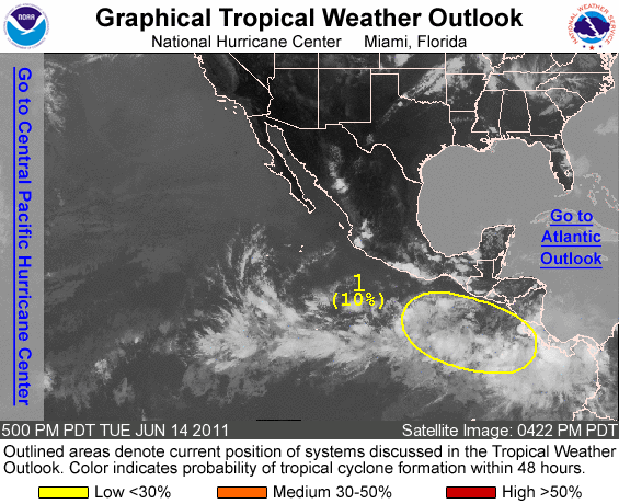
ZCZC MIATWOEP ALL TTAA00 KNHC DDHHMM TROPICAL WEATHER OUTLOOK NWS NATIONAL HURRICANE CENTER MIAMI FL 500 PM PDT TUE JUN 14 2011 FOR THE EASTERN NORTH PACIFIC...EAST OF 140 DEGREES WEST LONGITUDE.. 1. AN ELONGATED AREA OF DISORGANIZED SHOWERS AND THUNDERSTORMS EXTENDS FROM CENTRAL AMERICA WESTWARD TO SEVERAL HUNDRED MILES SOUTH OF THE GULF OF TEHUANTEPEC. ENVIRONMENTAL CONDITIONS APPEAR SOMEWHAT CONDUCIVE FOR DEVELOPMENT...AND THERE IS A LOW CHANCE...10 PERCENT...OF A TROPICAL CYCLONE FORMING WITHIN THIS AREA DURING THE NEXT 48 HOURS. $$ FORECASTER BERG NNNN
List of all Atlantic Outlooks
List of all East Pacific Outlooks
Quick Links and Additional Resources
Tropical Cyclone Forecasts
Tropical Cyclone Advisories
Tropical Weather Outlook
Audio/Podcasts
About Advisories
Marine Forecasts
Offshore Waters Forecasts
Gridded Forecasts
Graphicast
About Marine
Tropical Cyclone Advisories
Tropical Weather Outlook
Audio/Podcasts
About Advisories
Marine Forecasts
Offshore Waters Forecasts
Gridded Forecasts
Graphicast
About Marine
Social Media
NHC on Facebook
Twitter
YouTube
NHC Blog:
"Inside the Eye"
Hurricane Preparedness
Preparedness Guide
Hurricane Hazards
Watches and Warnings
Marine Safety
Ready.gov Hurricanes | en Español
Weather-Ready Nation
Emergency Management Offices


"Inside the Eye"
Hurricane Preparedness
Preparedness Guide
Hurricane Hazards
Watches and Warnings
Marine Safety
Ready.gov Hurricanes | en Español
Weather-Ready Nation
Emergency Management Offices
US Dept of Commerce
National Oceanic and Atmospheric Administration
National Hurricane Center
11691 SW 17th Street
Miami, FL, 33165
nhcwebmaster@noaa.gov
Central Pacific Hurricane Center
2525 Correa Rd
Suite 250
Honolulu, HI 96822
W-HFO.webmaster@noaa.gov