ZCZC MIATWOAT ALL
TTAA00 KNHC DDHHMM
Tropical Weather Outlook
NWS National Hurricane Center Miami FL
200 AM EDT Tue Aug 24 2021
For the North Atlantic...Caribbean Sea and the Gulf of Mexico:
The Weather Prediction Center is issuing Public Advisories on
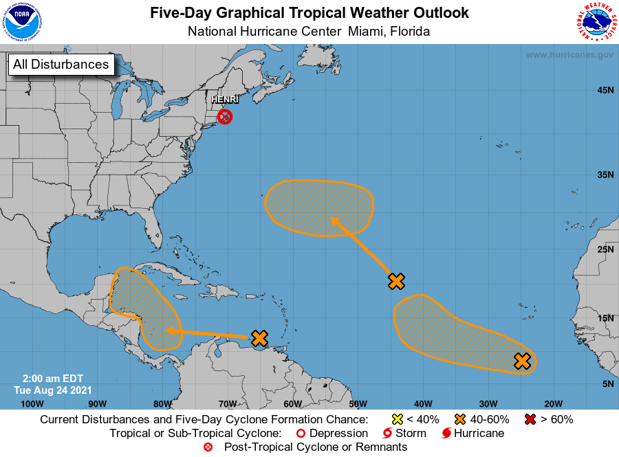
Post-Tropical Cyclone Henri, located inland near southern New
England.
1. A broad trough of low pressure is producing disorganized showers and
thunderstorms over the east-central tropical Atlantic more than 1000
miles west-northwest of the Cabo Verde Islands. Little development
is expected during the next day or two due to marginally conducive
ocean temperatures and strong upper-level winds. Afterwards,
environmental conditions are expected to become more favorable for
gradual development, and a tropical depression could form by the end
of the week while the system moves northwestward to northward at 10
to 15 mph over the central Atlantic.
* Formation chance through 48 hours...low...10 percent.
* Formation chance through 5 days...medium...50 percent.
2. A tropical wave over the eastern Caribbean Sea is expected to form a
broad area of low pressure over the southwestern Caribbean Sea later
this week. Thereafter, environmental conditions are forecast to be
favorable for gradual development, and a tropical depression could
form by the end of the week while the system moves
west-northwestward to northwestward over the northwestern Caribbean
Sea.
* Formation chance through 48 hours...low...near 0 percent.
* Formation chance through 5 days...medium...60 percent.
3. Another tropical wave over the far eastern tropical Atlantic located
about 500 miles south-southwest of the Cabo Verde Islands is
producing a concentrated area of showers and thunderstorms. This
activity has become a bit better organized tonight, and some
additional development is possible over the next several days while
this system moves westward to west-northwestward at 10 to 15 mph
over the eastern tropical Atlantic.
* Formation chance through 48 hours...low...20 percent.
* Formation chance through 5 days...medium...40 percent.
Public advisories issued by the Weather Prediction Center on
Post-Tropical Cyclone Henri can be found under AWIPS header
TCPAT3, WMO header WTNT33 KWNH, and on the web at
http://www.wpc.ncep.noaa.gov
Forecaster Papin/Beven