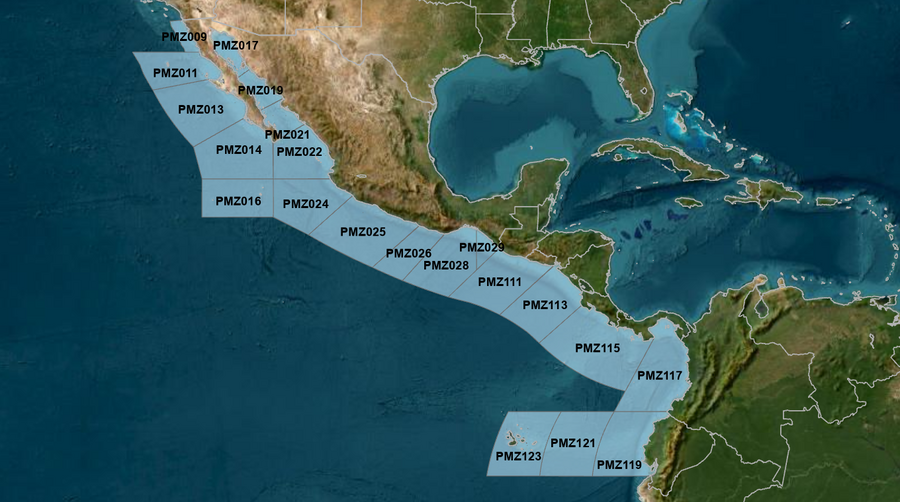
Hover to view popup zone forecast; click a zone to view related text forecast below. Show All Text Below
000
FZPN27 KNHC 200846
OFFPZ7

Offshore Waters Forecast
NWS National Hurricane Center Miami, FL
146 AM PDT Mon May 20 2024

Offshore Waters Forecast for the E Pacific within 250 nm of
Mexico

Seas given as significant wave height, which is the average
height of the highest 1/3 of the waves. Individual waves may be
more than twice the significant wave height.
PMZ001-202100-
Synopsis for the E Pacific within 250 nm of Mexico
146 AM PDT Mon May 20 2024

.SYNOPSIS...A broad surface ridge will continue to dominate the
offshore forecast waters of Baja California throughout the week.
The pressure gradient between this and lower pressures over
Mexico will continue to support moderate to fresh NW to N winds W
of the Baja California peninsula. Winds will pulse to strong
speeds N of Cabo San Lazaro Mon night. New NW swell will enter
the outer forecast waters of Baja California Norte today and
dominate Baja waters through Wed. Seas are expected to build 8 to
10 ft N of Punta Eugenia late today through Wed, with seas
subsiding below 8 ft on Thu. Light to moderate concentrations of
smoke, due to agricultural fires, are expected to maintain hazy
skies and may reduce visibility over portions of southern Mexico
through Tue.
PMZ009-202100-
Mexico Border S to 30N within 60 nm of shore-
146 AM PDT Mon May 20 2024

.TODAY...NW winds 10 to 15 kt. Seas 5 to 7 ft in W to NW swell.
Period 17 seconds.
.TONIGHT...NW winds 15 to 20 kt N of 31N, and NW to N 15 to
20 kt S of 31N. Seas 6 to 8 ft in NW swell. Period 16 seconds.
.TUE...NW winds 10 to 15 kt. Seas 6 to 8 ft in NW swell. Period
17 seconds.
.TUE NIGHT...NW winds 10 to 15 kt. Seas 6 to 8 ft in NW swell.
Period 17 seconds.
.WED...W to NW winds 10 kt. Seas 6 to 8 ft in NW swell. Period
13 seconds.
.WED NIGHT...NW winds 10 to 15 kt. Seas 5 to 7 ft in NW swell.
Period 12 seconds.
.THU...W to NW winds 10 to 15 kt. Seas 5 to 7 ft in NW swell.
Period 11 seconds.
.THU NIGHT...NW winds 10 to 15 kt. Seas 5 to 7 ft in NW swell.
Period 12 seconds.
.FRI...NW winds 10 to 15 kt. Seas 5 to 7 ft in NW swell. Period
10 seconds.
.FRI NIGHT...NW winds 15 to 20 kt. Seas 5 to 7 ft. Period
10 seconds.
Forecaster Stripling
PMZ011-202100-
30N to Punta Eugenia within 250 nm of shore-
146 AM PDT Mon May 20 2024

.TODAY...NW to N winds 15 to 20 kt. Seas 6 to 9 ft in NW swell.
Period 17 seconds.
.TONIGHT...NW to N winds 15 to 20 kt. Seas 7 to 10 ft in NW
swell. Period 16 seconds.
.TUE...NW winds 15 to 20 kt. Seas 7 to 10 ft in NW swell. Period
17 seconds.
.TUE NIGHT...NW winds 15 kt. Seas 7 to 10 ft in NW swell. Period
13 seconds.
.WED...NW winds 15 kt. Seas 7 to 10 ft in NW swell. Period
11 seconds.
.WED NIGHT...NW winds 15 kt. Seas 6 to 9 ft in NW swell. Period
10 seconds.
.THU...NW winds 15 kt. Seas 6 to 9 ft in NW swell. Period
10 seconds.
.THU NIGHT...NW winds 15 kt. Seas 6 to 9 ft in NW swell. Period
10 seconds.
.FRI...NW to N winds 15 kt. Seas 6 to 9 ft in NW swell. Period
10 seconds.
.FRI NIGHT...NW to N winds 15 to 20 kt. Seas 6 to 8 ft in NW to
N swell. Period 10 seconds.
Forecaster Stripling
PMZ013-202100-
Punta Eugenia to Cabo San Lazaro within 250 nm offshore-
146 AM PDT Mon May 20 2024

.TODAY...NW to N winds 15 to 20 kt. Seas 6 to 9 ft in NW swell.
Period 17 seconds.
.TONIGHT...NW to N winds 15 to 20 kt. Seas 6 to 9 ft in NW
swell. Period 17 seconds.
.TUE...NW to N winds 15 to 20 kt. Seas 6 to 9 ft in NW swell.
Period 17 seconds.
.TUE NIGHT...NW to N winds 15 to 20 kt. Seas 6 to 9 ft in NW
swell. Period 16 seconds.
.WED...NW to N winds 15 kt. Seas 6 to 9 ft in NW swell. Period
13 seconds.
.WED NIGHT...NW to N winds 15 kt. Seas 6 to 8 ft in NW swell.
Period 13 seconds.
.THU...NW to N winds 10 to 15 kt. Seas 6 to 8 ft in NW swell.
Period 12 seconds.
.THU NIGHT...NW to N winds 10 to 15 kt. Seas 5 to 7 ft in NW
swell. Period 12 seconds.
.FRI...NW to N winds 15 kt. Seas 5 to 7 ft in NW swell. Period
12 seconds.
.FRI NIGHT...NW to N winds 15 to 20 kt. Seas 5 to 7 ft. Period
11 seconds.
Forecaster Stripling
PMZ014-202100-
Cabo San Lazaro to Cabo San Lucas within 350 nm offshore N of
20N-
146 AM PDT Mon May 20 2024

.TODAY...NW to N winds 10 to 15 kt. Seas 6 to 8 ft in SW to W
swell. Period 17 seconds. Haze.
.TONIGHT...NW to N winds 10 to 15 kt. Seas 6 to 8 ft in W to NW
swell. Period 16 seconds. Haze.
.TUE...NW to N winds 15 to 20 kt. Seas 6 to 9 ft in W to NW
swell. Period 16 seconds.
.TUE NIGHT...NW to N winds 10 to 15 kt. Seas 6 to 8 ft in NW
swell. Period 16 seconds.
.WED...NW to N winds 10 to 15 kt. Seas 6 to 8 ft in NW swell.
Period 14 seconds.
.WED NIGHT...NW to N winds 15 kt. Seas 6 to 8 ft in NW swell.
Period 13 seconds.
.THU...NW to N winds 15 kt. Seas 5 to 7 ft in NW swell. Period
12 seconds.
.THU NIGHT...NW to N winds 10 to 15 kt. Seas 5 to 7 ft in NW
swell. Period 12 seconds.
.FRI...NW to N winds 15 kt. Seas 5 to 7 ft in NW swell. Period
11 seconds.
.FRI NIGHT...NW to N winds 15 kt. Seas 5 to 7 ft in NW swell.
Period 11 seconds.
Forecaster Stripling
PMZ016-202100-
From 17N to 20N Between 110W and 115W including the
Revillagigedo Islands-
146 AM PDT Mon May 20 2024

.TODAY...N winds 10 to 15 kt. Seas 6 to 8 ft in S to SW swell.
Period 16 seconds. Haze.
.TONIGHT...NW to N winds 10 to 15 kt. Seas 6 to 8 ft in S to SW
swell. Period 16 seconds. Haze.
.TUE...N winds 10 to 15 kt. Seas 6 to 8 ft in SW to W swell.
Period 16 seconds.
.TUE NIGHT...N winds 10 to 15 kt. Seas 6 to 8 ft in W to NW
swell. Period 15 seconds.
.WED...N winds 10 to 15 kt. Seas 5 to 7 ft in NW swell. Period
14 seconds.
.WED NIGHT...N winds 10 to 15 kt. Seas 5 to 7 ft in NW to N
swell. Period 13 seconds.
.THU...N winds 10 to 15 kt. Seas 5 to 7 ft in NW to N swell.
Period 12 seconds.
.THU NIGHT...N winds 10 to 15 kt. Seas 5 to 7 ft in NW to N
swell. Period 12 seconds.
.FRI...N winds 10 to 15 kt. Seas 5 to 7 ft in NW to N swell.
Period 11 seconds.
.FRI NIGHT...N winds 10 to 15 kt. Seas 5 to 7 ft in NW to N
swell. Period 11 seconds.
Forecaster Stripling
PMZ017-202100-
Northern Gulf of California-
146 AM PDT Mon May 20 2024

.TODAY...W to NW winds 10 kt, shifting to N in the afternoon.
Seas 2 to 4 ft. Period 4 seconds.
.TONIGHT...W winds 15 to 20 kt. Seas 2 to 4 ft. Period
4 seconds.
.TUE...W winds 10 kt, shifting to N in the afternoon. Seas 3 ft
or less. Period 5 seconds.
.TUE NIGHT...SW winds 10 kt. Seas 3 ft or less. Period
4 seconds.
.WED...S winds 10 kt. Seas 3 ft or less. Period 1 second.
.WED NIGHT...S to SW winds 10 to 15 kt. Seas 2 to 4 ft. Period
2 seconds.
.THU...S winds 10 to 15 kt. Seas 2 to 4 ft. Period 3 seconds.
.THU NIGHT...S to SW winds 10 to 15 kt. Seas 2 to 4 ft. Period
4 seconds.
.FRI...S winds 10 to 15 kt. Seas 2 to 4 ft. Period 3 seconds.
.FRI NIGHT...S to SW winds 10 to 15 kt. Seas 2 to 4 ft. Period
3 seconds.
Forecaster Stripling
PMZ019-202100-
Central Gulf of California-
146 AM PDT Mon May 20 2024

.TODAY...NW winds 10 to 15 kt. Seas 3 ft or less. Period
10 seconds.
.TONIGHT...NW winds 10 to 15 kt. Seas 3 ft or less. Period
10 seconds.
.TUE...NW to N winds 10 to 15 kt. Seas 3 ft or less. Period
5 seconds.
.TUE NIGHT...W to NW winds 10 to 15 kt. Seas 3 ft or less.
Period 9 seconds.
.WED...NW winds 10 kt. Seas 3 ft or less. Period 6 seconds.
.WED NIGHT...W winds 10 to 15 kt. Seas 2 to 4 ft. Period
6 seconds.
.THU...S winds 10 kt. Seas 2 to 4 ft. Period 10 seconds.
.THU NIGHT...SW to W winds 10 to 15 kt. Seas 2 to 4 ft. Period
10 seconds.
.FRI...W winds 10 kt. Seas 2 to 4 ft. Period 10 seconds.
.FRI NIGHT...SW to W winds 10 to 15 kt. Seas 3 ft or less.
Period 10 seconds.
Forecaster Stripling
PMZ021-202100-
Southern Gulf of California-
146 AM PDT Mon May 20 2024

.TODAY...SW winds 10 kt. Seas 3 to 5 ft. Period 17 seconds.
Haze.
.TONIGHT...Variable winds less than 5 kt. Seas 4 to 6 ft in S
swell. Period 17 seconds. Haze.
.TUE...Variable winds less than 5 kt, becoming W to NW 10 kt in
the afternoon. Seas 4 to 6 ft in S to SW swell. Period
17 seconds.
.TUE NIGHT...W winds 10 kt. Seas 3 to 5 ft. Period 17 seconds.
.WED...S winds 10 kt. Seas 3 to 5 ft. Period 13 seconds.
.WED NIGHT...S to SW winds 10 kt. Seas 2 to 4 ft. Period
12 seconds.
.THU...S winds 10 kt. Seas 2 to 4 ft. Period 12 seconds.
.THU NIGHT...SW to W winds 10 kt. Seas 2 to 4 ft. Period
12 seconds.
.FRI...W to NW winds 10 kt. Seas 2 to 4 ft. Period 12 seconds.
.FRI NIGHT...W winds 10 kt. Seas 2 to 4 ft. Period 11 seconds.
Forecaster Stripling
PMZ022-202100-
N of 20N E of 110W to the Entrance of the Gulf of California-
146 AM PDT Mon May 20 2024

.TODAY...SW to W winds 10 kt. Seas 5 to 7 ft in S to SW swell.
Period 17 seconds. Haze.
.TONIGHT...W to NW winds 10 kt. Seas 5 to 7 ft in S to SW swell.
Period 16 seconds. Haze.
.TUE...Variable winds less than 5 kt, becoming W 10 kt in the
afternoon. Seas 5 to 7 ft in S to SW swell. Period 16 seconds.
.TUE NIGHT...W winds 10 kt. Seas 5 to 7 ft in S to SW swell.
Period 16 seconds.
.WED...SW winds 10 kt. Seas 5 to 7 ft in S to SW swell. Period
15 seconds.
.WED NIGHT...SW to W winds 10 to 15 kt. Seas 5 to 7 ft in SW
swell. Period 14 seconds.
.THU...SW to W winds 10 kt. Seas 5 to 7 ft in SW swell. Period
14 seconds.
.THU NIGHT...W to NW winds 10 to 15 kt. Seas 5 to 7 ft in SW to
W swell. Period 13 seconds.
.FRI...W winds 10 to 15 kt. Seas 5 to 7 ft in SW to W swell.
Period 13 seconds.
.FRI NIGHT...NW winds 10 to 15 kt. Seas 5 to 7 ft in SW swell.
Period 13 seconds.
Forecaster Stripling
PMZ024-202100-
Colima and Jalisco within 300 nm offshore S of 20N and E of
110W-
146 AM PDT Mon May 20 2024

.TODAY...Variable winds less than 5 kt, becoming W to NW 10 kt
in the afternoon. Seas 5 to 7 ft in S to SW swell. Period
16 seconds. Haze.
.TONIGHT...NW winds 10 kt. Seas 5 to 7 ft in S to SW swell.
Period 16 seconds. Haze.
.TUE...Variable winds less than 5 kt, becoming W to NW 10 kt in
the afternoon. Seas 5 to 7 ft in S to SW swell. Period
16 seconds.
.TUE NIGHT...W to NW winds 10 kt in the evening, becoming
variable winds less than 5 kt. Seas 5 to 7 ft in S to SW swell.
Period 16 seconds.
.WED...Variable winds less than 5 kt. Seas 4 to 6 ft in S to SW
swell. Period 14 seconds.
.WED NIGHT...W to NW winds 10 kt. Seas 4 to 6 ft in SW swell.
Period 14 seconds.
.THU...NW to N winds 10 kt. Seas 4 to 6 ft in SW to W swell.
Period 13 seconds.
.THU NIGHT...NW winds 10 kt. Seas 5 to 7 ft in W to NW swell.
Period 13 seconds.
.FRI...NW winds 10 kt. Seas 5 to 7 ft in W to NW swell. Period
12 seconds.
.FRI NIGHT...NW winds 10 to 15 kt. Seas 5 to 7 ft in W to NW
swell. Period 12 seconds.
Forecaster Stripling
PMZ025-202100-
Michoacan and Guerrero within 250 nm offshore-
146 AM PDT Mon May 20 2024

.TODAY...N winds 10 kt. Seas 6 to 8 ft in S to SW swell. Period
16 seconds. Haze and areas of smoke.
.TONIGHT...NW winds 10 kt. Seas 5 to 7 ft in S to SW swell.
Period 16 seconds. Haze.
.TUE...Within 60 nm of shore, variable winds less than 5 kt,
becoming W 10 kt in the afternoon. Elsewhere, N to NE winds
10 kt in the morning, becoming variable winds less than 5 kt.
Seas 5 to 7 ft in S to SW swell. Period 16 seconds.
.TUE NIGHT...SW to W winds 10 kt in the evening, becoming
variable winds less than 5 kt. Seas 4 to 6 ft in S to SW swell.
Period 16 seconds.
.WED...N winds 10 kt. Seas 4 to 6 ft in S to SW swell. Period
14 seconds.
.WED NIGHT...W winds 10 kt. Seas 4 to 6 ft in S to SW swell.
Period 14 seconds.
.THU...NW to N winds 10 kt. Seas 5 to 7 ft in S to SW swell.
Period 14 seconds.
.THU NIGHT...W winds 10 kt. Seas 4 to 6 ft in S to SW swell.
Period 13 seconds.
.FRI...NW winds 10 kt. Seas 4 to 6 ft in S to SW swell. Period
13 seconds.
.FRI NIGHT...W to NW winds 10 kt. Seas 4 to 6 ft in S to SW
swell. Period 12 seconds.
Forecaster Stripling
PMZ026-202100-
Oaxaca W of Puerto Angel within 250 nm offshore-
146 AM PDT Mon May 20 2024

.TODAY...Variable winds less than 5 kt. Seas 6 to 8 ft in SW
swell. Period 16 seconds. Haze.
.TONIGHT...Variable winds less than 5 kt. Seas 5 to 7 ft in S to
SW swell. Period 17 seconds. Haze.
.TUE...N of 14N, W to NW winds 10 kt, shifting to S to SW in the
afternoon. S of 14N, variable winds less than 5 kt. Seas 5 to
7 ft in S to SW swell. Period 17 seconds.
.TUE NIGHT...SW winds 10 kt. Seas 5 to 7 ft in S to SW swell.
Period 16 seconds. Scattered showers and isolated tstms through
the night.
.WED...SW to W winds 10 kt N of 14N, and variable less than 5 kt
S of 14N. Seas 4 to 6 ft in S to SW swell. Period 14 seconds.
.WED NIGHT...W winds 10 kt. Seas 4 to 6 ft in S to SW swell.
Period 14 seconds.
.THU...W to NW winds 10 kt. Seas 5 to 7 ft in S to SW swell.
Period 14 seconds.
.THU NIGHT...SW to W winds 10 kt. Seas 4 to 6 ft in S to SW
swell. Period 13 seconds.
.FRI...W to NW winds 10 kt. Seas 4 to 6 ft in S to SW swell.
Period 13 seconds.
.FRI NIGHT...W winds 10 kt. Seas 4 to 6 ft in S to SW swell.
Period 13 seconds.
Forecaster Stripling
PMZ028-202100-
Oaxaca E of Puerto Angel within 300 nm offshore including the
Gulf of Tehuantepec-
146 AM PDT Mon May 20 2024

.TODAY...N of 14N, variable winds less than 5 kt, becoming S to
SW 10 kt in the afternoon. S of 14N, variable winds less than
5 kt. Seas 6 to 8 ft in S to SW swell. Period 17 seconds. Haze.
.TONIGHT...SW to W winds 10 kt N of 14N, and variable less than
5 kt S of 14N. Seas 5 to 7 ft in S to SW swell. Period
17 seconds. Haze.
.TUE...SW to W winds 10 kt N of 14N, and variable less than 5 kt
S of 14N. Seas 5 to 7 ft in S to SW swell. Period 16 seconds.
.TUE NIGHT...SW winds 10 kt. Seas 5 to 7 ft in S to SW swell.
Period 16 seconds. Scattered showers and isolated tstms through
the night.
.WED...W winds 10 kt. Seas 4 to 6 ft in S to SW swell. Period
15 seconds.
.WED NIGHT...SW to W winds 10 to 15 kt. Seas 4 to 6 ft. Period
14 seconds.
.THU...W winds 10 to 15 kt. Seas 5 to 7 ft in S to SW swell.
Period 14 seconds.
.THU NIGHT...SW to W winds 10 kt. Seas 4 to 6 ft in S swell.
Period 13 seconds.
.FRI...SW to W winds 10 kt. Seas 4 to 6 ft in S swell. Period
13 seconds.
.FRI NIGHT...SW to W winds 10 kt. Seas 4 to 6 ft in S swell.
Period 13 seconds.
Forecaster Stripling
PMZ029-202100-
Offshore Chiapas E of 94W-
146 AM PDT Mon May 20 2024

.TODAY...Variable winds less than 5 kt. Seas 5 to 7 ft in SW
swell. Period 17 seconds. Haze and areas of smoke.
.TONIGHT...Variable winds less than 5 kt. Seas 5 to 7 ft in SW
swell. Period 17 seconds. Haze. Scattered showers and isolated
tstms.
.TUE...Variable winds less than 5 kt, becoming SW to W 10 kt in
the afternoon. Seas 5 to 7 ft in SW swell. Period 16 seconds.
.TUE NIGHT...SW winds 10 kt in the evening, becoming variable
winds less than 5 kt. Seas 5 to 7 ft in SW swell. Period
16 seconds. Scattered showers and isolated tstms through the
night.
.WED...W winds 10 kt. Seas 4 to 6 ft in SW swell. Period
15 seconds.
.WED NIGHT...W winds 10 kt. Seas 4 to 6 ft in S to SW swell.
Period 14 seconds.
.THU...W winds 10 kt. Seas 4 to 6 ft in S to SW swell. Period
14 seconds.
.THU NIGHT...Variable winds less than 5 kt E of 93W, and SW to W
10 kt W of 93W. Seas 4 to 6 ft in S to SW swell. Period
14 seconds.
.FRI...Variable winds less than 5 kt. Seas 4 to 6 ft in S swell.
Period 13 seconds.
.FRI NIGHT...Variable winds less than 5 kt E of 93W, and SW
10 kt W of 93W. Seas 4 to 6 ft in S swell. Period 13 seconds.
Forecaster Stripling
076
FZPN28 KNHC 200848
OFFPZ8

Offshore Waters Forecast
NWS National Hurricane Center Miami, FL
148 AM PDT Mon May 20 2024

Offshore Waters Forecast for the E Pacific within 250 nm of
Central America, Colombia, and within 750 nm of Ecuador

Seas given as significant wave height, which is the average
height of the highest 1/3 of the waves. Individual waves may be
more than twice the significant wave height.
PMZ101-202100-
Synopsis for the E Pacific within 250 nm of Central America,
Colombia, and within 750 nm of Ecuador
148 AM PDT Mon May 20 2024

.SYNOPSIS...The monsoon trough extending along 09N-10N will help
to focus scattered showers and isolated thunderstorms over the
Central America waters south of 09N through Wed. Winds will
remain moderate to briefly fresh to the south of the monsoon
trough and moderate or weaker north of the trough through Wed.
New southwesterly swell is reaching the waters of Ecuador and the
Galapagos Islands this morning, and will support seas of 6 to 8
ft there through Tue night, while seas build to 5 to 7 ft
elsewhere this afternoon through Wed.
PMZ111-202100-
Guatemala and El Salvador to 250 nm offshore-
148 AM PDT Mon May 20 2024

.TODAY...Variable winds less than 5 kt, becoming NE to E 10 kt
in the afternoon. Seas 5 to 7 ft in SW swell. Period 17 seconds.
Haze.
.TONIGHT...SE to S winds 10 kt in the evening, becoming variable
winds less than 5 kt. Seas 5 to 7 ft in SW swell. Period
17 seconds. Haze.
.TUE...Variable winds less than 5 kt, becoming SW 10 kt in the
afternoon. Seas 5 to 7 ft in SW swell. Period 16 seconds.
Scattered showers and isolated tstms through the day.
.TUE NIGHT...SW winds 10 kt. Seas 5 to 7 ft in S to SW swell.
Period 16 seconds.
.WED...W to NW winds 10 kt. Seas 4 to 6 ft in S to SW swell.
Period 15 seconds.
.WED NIGHT...SW to W winds 10 kt. Seas 4 to 6 ft in S to SW
swell. Period 14 seconds.
.THU...W winds 10 kt. Seas 4 to 6 ft in S to SW swell. Period
14 seconds.
.THU NIGHT...SW winds 10 kt. Seas 4 to 6 ft in S to SW swell.
Period 14 seconds.
.FRI...Variable winds less than 5 kt. Seas 4 to 6 ft in S to SW
swell. Period 13 seconds.
.FRI NIGHT...Variable winds less than 5 kt. Seas 4 to 6 ft in S
swell. Period 13 seconds.
Forecaster Stripling
PMZ113-202100-
El Salvador to North Costa Rica including the Gulfs of Fonseca
and Papagayo-
148 AM PDT Mon May 20 2024

.TODAY...N to NE winds 10 to 15 kt. Seas 5 to 7 ft in SW swell.
Period 17 seconds. Haze. Scattered showers and isolated tstms.
.TONIGHT...S to SW winds 10 kt, shifting to NW late.
Seas 6 to 8 ft in SW swell. Period 17 seconds. Haze through the
night. Scattered showers and isolated tstms through the night.
.TUE...Offshore Gulf of Papagayo, NE to E winds 10 kt in the
morning, becoming variable winds less than 5 kt. Elsewhere, N
winds 10 kt, shifting to SW to W in the afternoon. Seas 6 to
8 ft in SW swell. Period 17 seconds. Scattered showers and
isolated tstms through the day.
.TUE NIGHT...Variable winds less than 5 kt Offshore Gulf of
Papagayo, and W 10 to 15 kt Elsewhere. Seas 5 to 7 ft in SW
swell. Period 16 seconds. Scattered showers and isolated tstms
through the night.
.WED...NW winds 10 kt. Seas 5 to 7 ft in S to SW swell. Period
15 seconds.
.WED NIGHT...SW to W winds 10 kt. Seas 5 to 7 ft in S to SW
swell. Period 14 seconds.
.THU...Variable winds less than 5 kt Offshore Gulf of Papagayo,
and W 10 kt Elsewhere. Seas 5 to 7 ft in S swell. Period
14 seconds.
.THU NIGHT...SW winds 10 kt. Seas 4 to 6 ft in S swell. Period
14 seconds.
.FRI...Variable winds less than 5 kt Offshore Gulf of Papagayo,
and SW to W 10 kt Elsewhere. Seas 4 to 6 ft in S swell. Period
13 seconds.
.FRI NIGHT...SW winds 10 kt. Seas 4 to 6 ft in S swell. Period
13 seconds.
Forecaster Stripling
PMZ115-202100-
North Costa Rica to West Panama to 250 nm offshore-
148 AM PDT Mon May 20 2024

.TODAY...SW to W winds 10 to 15 kt. Seas 6 to 8 ft in SW swell.
Period 17 seconds. Scattered tstms through the day.
.TONIGHT...SW to W winds 10 to 15 kt. Seas 6 to 8 ft in SW
swell. Period 17 seconds. Scattered showers and isolated tstms
through the night.
.TUE...SW to W winds 10 to 15 kt. Seas 6 to 8 ft in S to SW
swell. Period 17 seconds. Scattered tstms through the day.
.TUE NIGHT...SW to W winds 10 to 15 kt. Seas 6 to 8 ft in S to
SW swell. Period 16 seconds. Numerous showers and scattered
tstms through the night.
.WED...SW to W winds 10 to 15 kt. Seas 6 to 8 ft in S to SW
swell. Period 15 seconds.
.WED NIGHT...SW to W winds 10 to 15 kt. Seas 5 to 7 ft in S to
SW swell. Period 15 seconds.
.THU...SW to W winds 10 to 15 kt. Seas 6 to 8 ft in S to SW
swell. Period 14 seconds.
.THU NIGHT...SW to W winds 10 to 15 kt. Seas 6 to 8 ft in S to
SW swell. Period 14 seconds.
.FRI...SW to W winds 10 to 15 kt. Seas 5 to 7 ft in S swell.
Period 13 seconds.
.FRI NIGHT...SW to W winds 10 to 15 kt. Seas 4 to 6 ft. Period
13 seconds.
Forecaster Stripling
PMZ117-202100-
East Panama and Colombia including the Gulf of Panama-
148 AM PDT Mon May 20 2024

.TODAY...SW to W winds 10 to 15 kt. Seas 6 to 8 ft in SW swell.
Period 17 seconds. Scattered showers and isolated tstms through
the day.
.TONIGHT...SW to W winds 10 to 15 kt. Seas 6 to 8 ft in SW
swell. Period 17 seconds. Numerous showers and scattered tstms
through the night.
.TUE...SW winds 10 to 15 kt. Seas 6 to 8 ft in SW swell. Period
17 seconds. Numerous showers and scattered tstms through the
day.
.TUE NIGHT...SW winds 10 to 15 kt. Seas 5 to 7 ft in SW swell.
Period 16 seconds. Scattered tstms through the night.
.WED...SW winds 10 to 15 kt. Seas 5 to 7 ft in S to SW swell.
Period 15 seconds.
.WED NIGHT...SW winds 10 to 15 kt. Seas 5 to 7 ft in S to SW
swell. Period 14 seconds.
.THU...SW winds 10 to 15 kt. Seas 5 to 7 ft in S to SW swell.
Period 14 seconds.
.THU NIGHT...SW winds 10 to 15 kt. Seas 5 to 7 ft in S to SW
swell. Period 13 seconds.
.FRI...SW winds 10 to 15 kt. Seas 4 to 6 ft. Period 13 seconds.
.FRI NIGHT...SW to W winds 10 to 15 kt. Seas 4 to 6 ft. Period
13 seconds.
Forecaster Stripling
PMZ119-202100-
Ecuador including the Gulf of Guayaquil to 250 nm offshore-
148 AM PDT Mon May 20 2024

.TODAY...S to SW winds 10 to 15 kt. Seas 6 to 8 ft in SW swell.
Period 17 seconds.
.TONIGHT...S to SW winds 10 to 15 kt. Seas 6 to 8 ft in SW
swell. Period 17 seconds.
.TUE...S to SW winds 10 to 15 kt. Seas 6 to 8 ft in SW swell.
Period 16 seconds.
.TUE NIGHT...S to SW winds 10 to 15 kt. Seas 5 to 7 ft in S to
SW swell. Period 16 seconds.
.WED...S to SW winds 10 to 15 kt. Seas 5 to 7 ft in S to SW
swell. Period 14 seconds.
.WED NIGHT...S to SW winds 10 to 15 kt. Seas 5 to 7 ft in S to
SW swell. Period 14 seconds.
.THU...S to SW winds 10 to 15 kt. Seas 5 to 7 ft in S to SW
swell. Period 13 seconds.
.THU NIGHT...S to SW winds 10 to 15 kt. Seas 4 to 6 ft. Period
13 seconds.
.FRI...S to SW winds 10 to 15 kt. Seas 4 to 6 ft. Period
13 seconds.
.FRI NIGHT...S to SW winds 10 to 15 kt. Seas 4 to 6 ft. Period
12 seconds.
Forecaster Stripling
PMZ121-202100-
Ecuador between 250 and 500 nm offshore-
148 AM PDT Mon May 20 2024

.TODAY...S winds 10 to 15 kt. Seas 6 to 9 ft in S to SW swell.
Period 17 seconds.
.TONIGHT...S winds 10 to 15 kt. Seas 6 to 8 ft in S to SW swell.
Period 17 seconds.
.TUE...S winds 10 to 15 kt. Seas 6 to 8 ft in S to SW swell.
Period 16 seconds.
.TUE NIGHT...S winds 10 kt. Seas 6 to 8 ft in S to SW swell.
Period 16 seconds.
.WED...SE to S winds 10 to 15 kt. Seas 5 to 7 ft in S to SW
swell. Period 14 seconds.
.WED NIGHT...S winds 10 kt. Seas 5 to 7 ft in S to SW swell.
Period 14 seconds.
.THU...SE to S winds 10 to 15 kt. Seas 5 to 7 ft in S swell.
Period 13 seconds.
.THU NIGHT...S winds 10 kt. Seas 4 to 6 ft in S swell. Period
13 seconds.
.FRI...SE to S winds 10 kt. Seas 4 to 6 ft in S swell. Period
12 seconds.
.FRI NIGHT...SE to S winds 10 kt. Seas 4 to 6 ft in S swell.
Period 12 seconds.
Forecaster Stripling
PMZ123-202100-
Offshore Galapagos Islands-
148 AM PDT Mon May 20 2024

.TODAY...SE to S winds 10 to 15 kt. Seas 6 to 9 ft in S to SW
swell. Period 17 seconds.
.TONIGHT...SE to S winds 10 to 15 kt. Seas 6 to 8 ft in S to SW
swell. Period 16 seconds.
.TUE...SE to S winds 10 to 15 kt. Seas 6 to 8 ft in S to SW
swell. Period 15 seconds.
.TUE NIGHT...SE to S winds 10 kt. Seas 6 to 8 ft in S to SW
swell. Period 15 seconds.
.WED...SE to S winds 10 to 15 kt. Seas 5 to 7 ft in S swell.
Period 12 seconds.
.WED NIGHT...SE to S winds 10 kt. Seas 5 to 7 ft in S swell.
Period 12 seconds.
.THU...SE to S winds 10 to 15 kt. Seas 5 to 7 ft in S swell.
Period 12 seconds.
.THU NIGHT...SE to S winds 10 kt. Seas 4 to 6 ft in S swell.
Period 12 seconds.
.FRI...SE to S winds 10 kt. Seas 5 to 7 ft in S swell. Period
12 seconds.
.FRI NIGHT...SE winds 10 to 15 kt. Seas 5 to 7 ft in S swell.
Period 13 seconds.
Forecaster Stripling
000
FZNT02 KNHC 201356
HSFAT2

HIGH SEAS FORECAST
NWS NATIONAL HURRICANE CENTER MIAMI FL
1630 UTC MON MAY 20 2024

SUPERSEDED BY NEXT ISSUANCE IN 6 HOURS

SEAS GIVEN AS SIGNIFICANT WAVE HEIGHT...WHICH IS THE AVERAGE
HEIGHT OF THE HIGHEST 1/3 OF THE WAVES. INDIVIDUAL WAVES MAY BE
MORE THAN TWICE THE SIGNIFICANT WAVE HEIGHT.

SECURITE

ATLANTIC FROM 07N TO 31N W OF 35W INCLUDING CARIBBEAN SEA AND
GULF OF MEXICO

SYNOPSIS VALID 1200 UTC MON MAY 20.
24 HOUR FORECAST VALID 1200 UTC TUE MAY 21.
48 HOUR FORECAST VALID 1200 UTC WED MAY 22.

.WARNINGS.

.NONE.

.SYNOPSIS AND FORECAST.

.CARIBBEAN WITHIN 14N67W TO 15N72W TO 14N77W TO 11N77W TO 11N75W
TO 12N67W TO 14N67W...INCLUDING THE GULF OF VENEZUELA... E WINDS
20 TO 25 KT. SEAS 8 TO 9 FT.
.24 HOUR FORECAST WITHIN 15N70W TO 16N74W TO 14N75W TO 12N71W TO
13N68W TO 15N70W...INCLUDING THE GULF OF VENEZUELA... E WINDS 20
TO 25 KT. SEAS 8 TO 9 FT.
.48 HOUR FORECAST WITHIN 18N71W TO 19N74W TO 17N78W TO 14N76W TO
14N72W TO 14N70W TO 18N71W...INCLUDING BETWEEN CUBA AND JAMAICA
AND IN MONA PASSAGE... E WINDS 20 TO 30 KT. SEAS 8 TO 9 FT.

.REMAINDER OF AREA WINDS 20 KT OR LESS. SEAS LESS THAN 8 FT.

$$
.FORECASTER AL. NATIONAL HURRICANE CENTER.
089
FZPN03 KNHC 200750
HSFEP2

HIGH SEAS FORECAST
NWS NATIONAL HURRICANE CENTER MIAMI FL
1030 UTC MON MAY 20 2024

SUPERSEDED BY NEXT ISSUANCE IN 6 HOURS

SEAS GIVEN AS SIGNIFICANT WAVE HEIGHT...WHICH IS THE AVERAGE
HEIGHT OF THE HIGHEST 1/3 OF THE WAVES. INDIVIDUAL WAVES MAY BE
MORE THAN TWICE THE SIGNIFICANT WAVE HEIGHT.

SECURITE

E PACIFIC FROM THE EQUATOR TO 30N E OF 140W AND 03.4S TO THE
EQUATOR E OF 120W

SYNOPSIS VALID 0600 UTC MON MAY 20.
24 HOUR FORECAST VALID 0600 UTC TUE MAY 21.
48 HOUR FORECAST VALID 0600 UTC WED MAY 22.

.WARNINGS.

.NONE.

.SYNOPSIS AND FORECAST.

.WITHIN 30N125W TO 30N134W TO 29N133W TO 29N131W TO 29N129W TO
30N125W WINDS 20 KT OR LESS. SEAS 8 FT IN N TO NE SWELL.
.24 HOUR FORECAST WITHIN 30N118W TO 30N137W TO 27N136W TO
25N125W TO 28N119W TO 30N118W WINDS 20 KT OR LESS. SEAS 8 TO 10
FT IN N TO NE SWELL.
.48 HOUR FORECAST WITHIN 27N139W TO 28N139W TO 28N140W TO
25N140W TO 26N139W TO 27N139W NE TO E WINDS 20 TO 25 KT. SEAS 9
FT IN NE SWELL. ELSEWHERE WITHIN 30N140W TO 07N140W TO 07N137W TO
22N128W TO 30N140W...INCLUDING WITHIN 60 NM OF SHORE... WINDS 20
KT OR LESS. SEAS 8 TO 11 FT IN N TO NE SWELL.

.WITHIN 17N123W TO 19N140W TO 06N140W TO 08N127W TO 02N116W TO
10N106W TO 17N123W WINDS 20 KT OR LESS. SEAS 8 TO 10 FT IN MIXED
SWELL.
.24 HOUR FORECAST WITHIN 19N134W TO 24N133W TO 23N137W TO
28N140W TO 06N140W TO 09N133W TO 19N134W WINDS 20 KT OR LESS.
SEAS 8 TO 10 FT IN NE SWELL.
.48 HOUR FORECAST CONDITIONS MERGED WITH AREA OF N TO NE SWELL
DESCRIBED ABOVE.

.WITHIN 01N96W TO 05N98W TO 05N106W TO 03.4S108W TO 03.4S86W TO
01N96W WINDS 20 KT OR LESS. SEAS 8 TO 9 FT IN SW SWELL.
.24 HOUR FORECAST WITHIN 03S87W TO 02S88W TO 03S90W TO 03S91W TO
03.4S93W TO 03.4S86W TO 03S87W WINDS 20 KT OR LESS. SEAS 8 FT IN
S TO SW SWELL. WITHIN 06N92W TO 07N94W TO 06N97W TO 05N99W TO
05N104W TO 03N102W TO 06N92W WINDS 20 KT OR LESS. SEAS 8 FT IN SW
SWELL.
.48 HOUR FORECAST LOW PRES NEAR 11N108W 1008 MB. WITHIN
09N107.5W TO 09N108W TO 08.5N108.5W TO 08.5N109W TO 08N109W TO
08.5N108W TO 09N107.5W SW TO W WINDS 20 TO 25 KT. SEAS 8 FT IN SW
SWELL. ELSEWHERE WITHIN 08N102W TO 08N104W TO 10N106W TO 08N110W
TO 06N105W TO 07N101W TO 08N102W WINDS 20 KT OR LESS. SEAS 8 FT
IN SW SWELL.

.09 HOUR FORECAST WITHIN 25N114W TO 27N115W TO 25N118W TO
23N118W TO 22N117W TO 24N115W TO 25N114W...INCLUDING WITHIN 60
NM OF SHORE... WINDS 20 KT OR LESS. SEAS 8 FT IN MERGING NW AND
SW SWELL.
.24 HOUR FORECAST WITHIN 25N113W TO 26N115W TO 25N118W TO
20N121W TO 19N119W TO 23N113W TO 25N113W...INCLUDING WITHIN 60 NM
OF SHORE... WINDS 20 KT OR LESS. SEAS 8 FT IN MERGING NW AND SW
SWELL.
.36 HOUR FORECAST CONDITIONS MERGED WITH AREA OF NW SWELL
DESCRIBED ABOVE.

.REMAINDER OF AREA WINDS 20 KT OR LESS. SEAS LESS THAN 8 FT.

CONVECTION VALID AT 0730 UTC MON MAY 20...

.INTERTROPICAL CONVERGENCE ZONE/MONSOON TROUGH...
MONSOON TROUGH FROM NEAR 10.5N74W TO 09N92W TO 12.5N103W TO
08N124W. ITCZ FROM 08N124W TO BEYOND 06.5N140W. SCATTERED
MODERATE TO STRONG CONVECTION FROM 04.5N TO 09N E OF 94W.
SCATTERED MODERATE ISOLATED STRONG CONVECTION FROM 04N TO 10N
AND W OF 119W TO BEYOND 140W.

$$
.FORECASTER STRIPLING. NATIONAL HURRICANE CENTER.