


NHC Graphical Outlook Archive
|
« Earliest Available ‹ Earlier Later › Latest Available » |
GIS Shapefiles |
| Central Pacific | Eastern Pacific | Atlantic |
|
Tropical Weather Outlook Text
ZCZC MIATWOAT ALL
TTAA00 KNHC DDHHMM
Tropical Weather Outlook
NWS National Hurricane Center Miami FL
200 PM EDT Fri Sep 20 2024
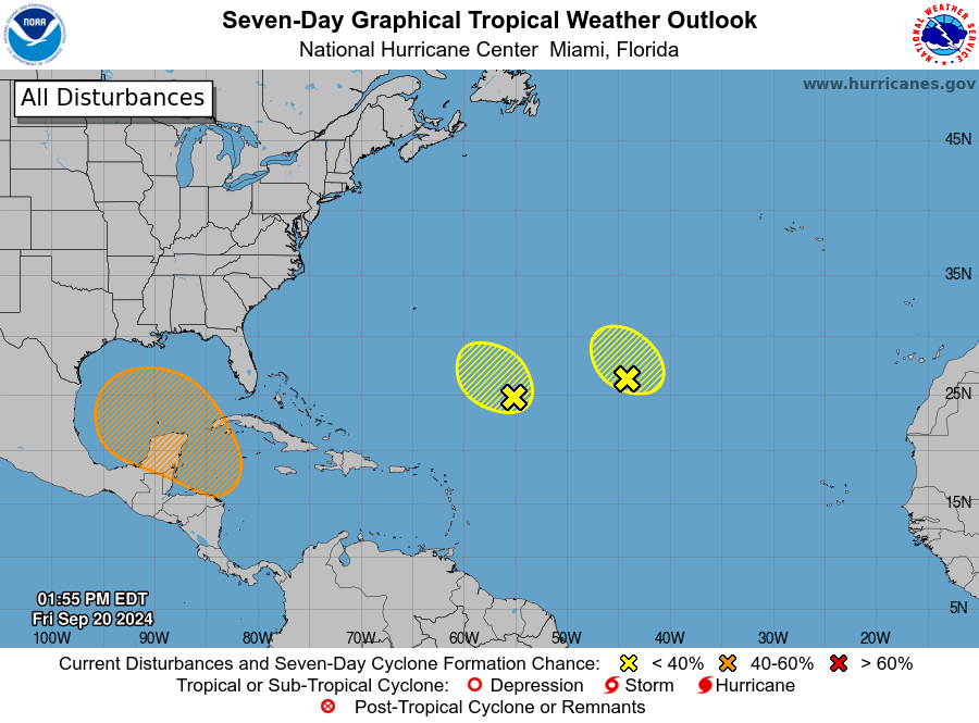
For the North Atlantic...Caribbean Sea and the Gulf of Mexico:
1. Central Subtropical Atlantic (Remnants of Gordon):
Showers and thunderstorms have been displaced farther away from the
center of an area of low pressure (the remnants of Gordon) located
over a thousand miles southwest of the Azores due to strong
upper-level winds. Significant development of this system is
not expected while it meanders over the central subtropical Atlantic
during the next couple of days.
* Formation chance through 48 hours...low...10 percent.
* Formation chance through 7 days...low...10 percent.
2. Central and Western Subtropical Atlantic (AL96):
An area of low pressure located about 650 miles northeast of the
northern Leeward Islands is producing disorganized showers and a
few thunderstorms. Environmental conditions do not appear conducive
for significant development of this system during the next couple of
days while it drifts northwestward at about 5 mph over the central
or western subtropical Atlantic.
* Formation chance through 48 hours...low...10 percent.
* Formation chance through 7 days...low...10 percent.
3. Northwestern Caribbean Sea and Southern Gulf of Mexico:
A broad area of low pressure could form by the early to middle
part of next week over the northwestern Caribbean Sea. Thereafter,
gradual development of this system is possible, and a tropical
depression could form as the system moves slowly to the north or
northwest over the northwestern Caribbean Sea and into the southern
Gulf of Mexico through the end of next week.
* Formation chance through 48 hours...low...near 0 percent.
* Formation chance through 7 days...medium...50 percent.
Forecaster Berg
List of Atlantic Outlooks (May 2023 - Present)
List of East Pacific Outlooks (May 2023 - Present)
List of Central Pacific Outlooks (May 2023 - Present)
List of Atlantic Outlooks (July 2014 - April 2023)
List of East Pacific Outlooks (July 2014 - April 2023)
List of Central Pacific Outlooks (June 2019 - April 2023)
List of Atlantic Outlooks (June 2009 - June 2014)
List of East Pacific Outlooks (June 2009 - June 2014)