


NHC Offshore Waters Forecasts
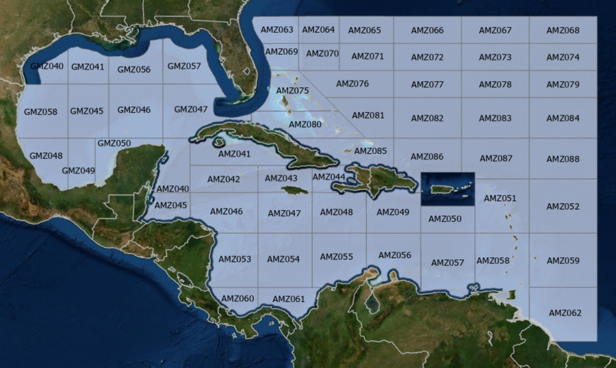
Hover to view popup zone forecast; click a zone to view related text forecast below. Show All Text Below
Southwest Tropical North Atlantic & Caribbean Sea (OFFNT3)
503
FZNT23 KNHC 300209
OFFNT3

Offshore Waters Forecast for the Caribbean Sea and Tropical
N Atlantic
NWS National Hurricane Center Miami, FL
1009 PM EDT Tue Apr 29 2025

Offshore Waters Forecast for Caribbean Sea, and the Tropical N
Atlantic from 07N to 19N W of 55W.

Seas given as significant wave height, which is the average
height of the highest 1/3 of the waves. Individual waves may be
more than twice the significant wave height.
Synopsis for the Caribbean Sea & Tropical North Atlantic
AMZ001-301415-
Synopsis for Caribbean Sea, and Tropical N Atlantic from 07N to
19N W of 55W
1009 PM EDT Tue Apr 29 2025

.SYNOPSIS...High pressure north of the basin combined with the
Colombian Low will support pulsing fresh to strong trades at night
over the Windward Passage and south of Cuba through Thu night.
Elsewhere, tranquil conditions should prevail over the forecast
waters through the weekend.
AMZ040 Zone Forecast
AMZ040-301415-
Caribbean N of 18N W of 85W including Yucatan Basin-
1009 PM EDT Tue Apr 29 2025

.OVERNIGHT...E winds 10 to 15 kt. Seas 3 to 5 ft.
.WED...E winds 15 to 20 kt. Seas 3 to 5 ft.
.WED NIGHT...E winds 10 to 15 kt. Seas 3 to 5 ft.
.THU...E to SE winds 10 to 15 kt. Seas 3 to 5 ft.
.THU NIGHT...E to SE winds 10 to 15 kt. Seas 3 to 5 ft.
.FRI...E to SE winds 10 to 15 kt. Seas 3 to 5 ft.
.FRI NIGHT...E to SE winds 10 to 15 kt. Seas 3 to 5 ft.
.SAT...E to SE winds 10 to 15 kt. Seas 3 to 5 ft.
.SAT NIGHT...E winds 10 to 15 kt. Seas 3 to 5 ft.
.SUN...E to SE winds 10 to 15 kt. Seas 3 to 5 ft.
.SUN NIGHT...E winds 10 to 15 kt. Seas 3 to 5 ft.
Forecaster Aguirre
AMZ041 Zone Forecast
AMZ041-301415-
Caribbean N of 20N E of 85W-
1009 PM EDT Tue Apr 29 2025

.OVERNIGHT...NE to E winds 15 to 20 kt W of 81W, and NE to E
20 to 25 kt E of 81W. Seas 3 to 5 ft.
.WED...E winds 15 to 20 kt. Seas 3 to 5 ft.
.WED NIGHT...E winds 15 to 20 kt W of 81W, and NE to E 20 to
25 kt E of 81W. Seas 4 to 6 ft.
.THU...E winds 15 to 20 kt. Seas 4 to 6 ft.
.THU NIGHT...E winds 10 to 15 kt W of 81W, and NE to E 15 to
20 kt E of 81W. Seas 3 to 5 ft.
.FRI...E to SE winds 10 to 15 kt. Seas 3 to 5 ft.
.FRI NIGHT...E winds 10 to 15 kt. Seas 3 to 5 ft.
.SAT...E to SE winds 10 to 15 kt. Seas 3 to 5 ft.
.SAT NIGHT...W of 81W, E winds 10 kt. E of 81W, variable winds
less than 5 kt, becoming NE to E 10 kt early in the morning. Seas
2 to 4 ft.
.SUN...E to SE winds 10 to 15 kt. Seas 3 to 4 ft.
.SUN NIGHT...NE to E winds 10 kt. Seas 3 to 4 ft.
Forecaster Aguirre
AMZ042 Zone Forecast
AMZ042-301415-
Caribbean from 18N-20N between 80W-85W including Cayman Basin-
1009 PM EDT Tue Apr 29 2025

.OVERNIGHT...NE to E winds 15 to 20 kt. Seas 3 to 5 ft.
.WED...NE to E winds 15 to 20 kt. Seas 3 to 5 ft.
.WED NIGHT...NE to E winds 15 to 20 kt. Seas 3 to 5 ft.
.THU...E winds 10 to 15 kt. Seas 3 to 5 ft.
.THU NIGHT...E winds 10 to 15 kt. Seas 3 to 5 ft.
.FRI...E winds 10 to 15 kt. Seas 3 to 5 ft.
.FRI NIGHT...E winds 10 to 15 kt. Seas 3 to 5 ft.
.SAT...E to SE winds 10 to 15 kt. Seas 3 to 5 ft.
.SAT NIGHT...E winds 10 to 15 kt. Seas 3 to 5 ft.
.SUN...E winds 10 to 15 kt. Seas 3 to 5 ft.
.SUN NIGHT...NE to E winds 10 kt. Seas 3 to 5 ft.
Forecaster Aguirre
AMZ043 Zone Forecast
AMZ043-301415-
Caribbean from 18N-20N between 76W-80W-
1009 PM EDT Tue Apr 29 2025

.OVERNIGHT...NE to E winds 15 to 20 kt. Seas 4 to 6 ft.
.WED...NE to E winds 15 to 20 kt W of 78W, and E 15 to 20 kt E of
78W. Seas 4 to 6 ft.
.WED NIGHT...NE to E winds 15 to 20 kt. Seas 5 to 7 ft.
.THU...NE to E winds 15 to 20 kt W of 78W, and E 10 to 15 kt E of
78W. Seas 4 to 6 ft.
.THU NIGHT...NE to E winds 10 to 15 kt. Seas 4 to 6 ft.
.FRI...E winds 10 to 15 kt. Seas 4 to 6 ft.
.FRI NIGHT...E winds 10 to 15 kt. Seas 3 to 5 ft.
.SAT...E winds 10 kt. Seas 3 to 4 ft.
.SAT NIGHT...E winds 10 kt. Seas 2 to 4 ft.
.SUN...E winds 10 kt. Seas 2 to 4 ft.
.SUN NIGHT...W of 78W, variable winds less than 5 kt, becoming NE
to E 10 kt early in the morning. E of 78W, E winds 10 kt. Seas
2 to 4 ft.
Forecaster Aguirre
AMZ044 Zone Forecast
AMZ044-301415-
Caribbean approaches to the Windward Passage-
1009 PM EDT Tue Apr 29 2025

.OVERNIGHT...NE winds 10 to 15 kt in the Gulf of Gonave, and NE
20 to 25 kt elsewhere. Seas 4 to 6 ft.
.WED...N to NE winds 10 to 15 kt in the Gulf of Gonave, and NE
20 to 25 kt elsewhere. Seas 4 to 6 ft.
.WED NIGHT...NE to E winds 10 to 15 kt in the Gulf of Gonave, and
NE 20 to 25 kt elsewhere. Seas 5 to 7 ft.
.THU...In the Gulf of Gonave, NE to E winds 10 kt, shifting to NW
to N early in the evening. Elsewhere, NE to E winds 15 to 20 kt.
Seas 4 to 6 ft.
.THU NIGHT...In the Gulf of Gonave, NE to E winds 10 kt. Seas
2 to 4 ft. Elsewhere, NE to E winds 15 to 20 kt. Seas 4 to 6 ft.
.FRI...In the Gulf of Gonave, E winds 10 kt in the late morning
and early afternoon, becoming variable less than 5 kt. Elsewhere,
NE to E winds 10 to 15 kt. Seas 3 ft or less in the Gulf of
Gonave, and 3 to 5 ft elsewhere.
.FRI NIGHT...E winds 10 kt in the Gulf of Gonave, and NE to E
15 to 20 kt elsewhere. Seas 3 to 5 ft.
.SAT...Variable winds less than 5 kt in the Gulf of Gonave, and E
10 kt elsewhere. Seas 2 to 4 ft.
.SAT NIGHT...Variable winds less than 5 kt in the Gulf of Gonave,
and NE to E 10 to 15 kt elsewhere. Seas 2 to 4 ft.
.SUN...Variable winds less than 5 kt in the Gulf of Gonave, and E
10 kt elsewhere. Seas 3 ft or less.
.SUN NIGHT...Variable winds less than 5 kt in the Gulf of Gonave,
and NE to E 10 to 15 kt elsewhere. Seas 3 ft or less.
Forecaster Aguirre
AMZ045 Zone Forecast
AMZ045-301415-
Gulf of Honduras-
1009 PM EDT Tue Apr 29 2025

.OVERNIGHT...E winds 10 to 15 kt. Seas 3 to 5 ft.
.WED...E winds 10 to 15 kt. Seas 3 to 5 ft.
.WED NIGHT...E winds 15 to 20 kt. Seas 3 to 5 ft.
.THU...E winds 10 to 15 kt. Seas 3 to 5 ft.
.THU NIGHT...E winds 15 to 20 kt. Seas 3 to 5 ft.
.FRI...E winds 10 to 15 kt. Seas 4 to 6 ft.
.FRI NIGHT...E winds 15 to 20 kt. Seas 4 to 6 ft.
.SAT...E winds 10 to 15 kt. Seas 3 to 5 ft.
.SAT NIGHT...E winds 15 to 20 kt. Seas 4 to 6 ft.
.SUN...E winds 10 to 15 kt S of 17N W of 86W, and E 15 to 20 kt
elsewhere. Seas 3 to 5 ft S of 17N W of 86W, and 4 to 6 ft
elsewhere.
.SUN NIGHT...E winds 15 kt. Seas 3 to 5 ft.
Forecaster Aguirre
AMZ046 Zone Forecast
AMZ046-301415-
Caribbean from 15N to 18N between 80W and 85W-
1009 PM EDT Tue Apr 29 2025

.OVERNIGHT...NE to E winds 10 to 15 kt. Seas 3 to 5 ft.
.WED...NE to E winds 10 to 15 kt. Seas 3 to 5 ft.
.WED NIGHT...NE to E winds 10 to 15 kt. Seas 3 to 5 ft.
.THU...E winds 10 to 15 kt. Seas 3 to 5 ft.
.THU NIGHT...E winds 10 to 15 kt. Seas 3 to 5 ft.
.FRI...E winds 10 to 15 kt. Seas 3 to 5 ft.
.FRI NIGHT...E winds 10 to 15 kt. Seas 3 to 5 ft W of 82W, and
2 to 3 ft E of 82W.
.SAT...E to SE winds 10 to 15 kt. Seas 3 to 5 ft.
.SAT NIGHT...E winds 10 to 15 kt. Seas 3 to 5 ft.
.SUN...E to SE winds 10 to 15 kt. Seas 3 to 5 ft.
.SUN NIGHT...E winds 10 to 15 kt. Seas 3 to 5 ft.
Forecaster Aguirre
AMZ047 Zone Forecast
AMZ047-301415-
Caribbean from 15N to 18N between 76W and 80W-
1009 PM EDT Tue Apr 29 2025

.OVERNIGHT...NE to E winds 10 to 15 kt S of 17N, and NE 15 to
20 kt N of 17N. Seas 4 to 6 ft.
.WED...NE to E winds 10 to 15 kt S of 17N, and NE to E 15 to
20 kt N of 17N. Seas 4 to 6 ft.
.WED NIGHT...NE to E winds 10 to 15 kt. Seas 4 to 6 ft. Scattered
showers.
.THU...NE to E winds 10 to 15 kt. Seas 3 to 5 ft.
.THU NIGHT...E winds 10 to 15 kt. Seas 3 to 5 ft.
.FRI...E winds 10 to 15 kt. Seas 3 to 5 ft.
.FRI NIGHT...E winds 10 to 15 kt. Seas 3 to 5 ft.
.SAT...E winds 10 kt. Seas 3 to 4 ft.
.SAT NIGHT...E winds 10 to 15 kt. Seas 3 to 5 ft.
.SUN...E winds 10 kt. Seas 3 to 4 ft.
.SUN NIGHT...E winds 10 kt. Seas 3 ft or less.
Forecaster Aguirre
AMZ048 Zone Forecast
AMZ048-301415-
Caribbean from 15N to 18N between 72W and 76W-
1009 PM EDT Tue Apr 29 2025

.OVERNIGHT...NE to E winds 10 to 15 kt S of 17N, and NE to E
15 to 20 kt N of 17N. Seas 4 to 6 ft.
.WED...NE to E winds 10 to 15 kt. Seas 4 to 6 ft. Scattered
showers.
.WED NIGHT...NE to E winds 10 to 15 kt. Seas 4 to 6 ft. Scattered
showers.
.THU...E winds 10 to 15 kt. Seas 3 to 5 ft. Scattered showers.
.THU NIGHT...E winds 10 to 15 kt. Seas 3 to 5 ft.
.FRI...E winds 10 to 15 kt. Seas 3 to 5 ft.
.FRI NIGHT...E winds 10 to 15 kt. Seas 3 to 5 ft.
.SAT...E winds 10 to 15 kt. Seas 3 to 5 ft.
.SAT NIGHT...E winds 10 to 15 kt. Seas 3 to 5 ft.
.SUN...E winds 10 to 15 kt. Seas 3 to 5 ft.
.SUN NIGHT...E winds 10 kt. Seas 3 to 4 ft.
Forecaster Aguirre
AMZ049 Zone Forecast
AMZ049-301415-
Caribbean N of 15N between 68W and 72W-
1009 PM EDT Tue Apr 29 2025

.OVERNIGHT...NE to E winds 15 to 20 kt W of 70W, and NE 10 to
15 kt E of 70W. Seas 3 to 5 ft. Scattered showers.
.WED...NE to E winds 15 to 20 kt W of 70W, and NE to E 10 to
15 kt E of 70W. Seas 3 to 5 ft. Scattered showers.
.WED NIGHT...NE to E winds 15 to 20 kt W of 70W, and NE to E
10 to 15 kt E of 70W. Seas 3 to 5 ft. Scattered showers.
.THU...E winds 15 to 20 kt W of 70W, and NE to E 10 to 15 kt E of
70W. Seas 3 to 5 ft. Scattered showers.
.THU NIGHT...NE to E winds 15 to 20 kt W of 70W, and NE to E
10 to 15 kt E of 70W. Seas 2 to 4 ft.
.FRI...E winds 15 to 20 kt W of 70W, and NE to E 10 to 15 kt E of
70W. Seas 2 to 4 ft.
.FRI NIGHT...NE to E winds 10 to 15 kt. Seas 2 to 4 ft.
.SAT...E winds 10 to 15 kt. Seas 2 to 4 ft.
.SAT NIGHT...E winds 10 to 15 kt. Seas 2 to 4 ft.
.SUN...E winds 10 to 15 kt. Seas 3 ft or less.
.SUN NIGHT...E winds 10 kt. Seas 3 ft or less.
Forecaster Aguirre
AMZ050 Zone Forecast
AMZ050-301415-
Caribbean N of 15N between 64W and 68W-
1009 PM EDT Tue Apr 29 2025

.OVERNIGHT...NE to E winds 10 kt. Seas 3 to 4 ft. Scattered
showers.
.WED...E winds 10 kt. Seas 3 to 4 ft. Scattered showers.
.WED NIGHT...NE to E winds 10 kt. Seas 3 to 4 ft.
Scattered showers.
.THU...E winds 10 kt. Seas 3 to 4 ft. Scattered showers.
.THU NIGHT...NE to E winds 10 kt. Seas 3 to 4 ft.
.FRI...NE to E winds 10 kt. Seas 3 to 4 ft.
.FRI NIGHT...NE to E winds 10 kt. Seas 3 to 4 ft.
.SAT...E winds 10 kt. Seas 3 to 4 ft.
.SAT NIGHT...NE to E winds 10 kt. Seas 3 to 4 ft.
.SUN...E winds 10 kt. Seas 3 to 4 ft.
.SUN NIGHT...E winds 10 kt. Seas 3 to 4 ft.
Forecaster Aguirre
AMZ051 Zone Forecast
AMZ051-301415-
Offshore Waters Leeward Islands-
1009 PM EDT Tue Apr 29 2025

.OVERNIGHT...E winds 10 kt. Seas 3 to 5 ft. Isolated showers.
.WED...E to SE winds 10 kt in the late morning and early
afternoon, becoming variable less than 5 kt. Seas 3 to 5 ft in
E swell. Isolated showers.
.WED NIGHT...NE to E winds 10 kt. Seas 3 to 5 ft in E swell.
Isolated showers.
.THU...E winds 10 kt. Seas 3 to 5 ft in E swell. Isolated showers.
.THU NIGHT...NE to E winds 10 kt. Seas 3 to 5 ft in E swell.
Isolated showers.
.FRI...NE to E winds 10 kt. Seas 3 to 5 ft in E swell.
.FRI NIGHT...NE to E winds 10 to 15 kt. Seas 3 to 5 ft in E swell.
.SAT...NE to E winds 10 kt. Seas 3 to 5 ft in E swell.
.SAT NIGHT...NE to E winds 10 kt. Seas 3 to 5 ft in E swell.
.SUN...E winds 10 kt in the late morning and early afternoon,
becoming variable less than 5 kt. Seas 3 to 5 ft in E swell.
.SUN NIGHT...In the Caribbean, NE to E winds 10 kt. In the Atlc,
NE to E winds 10 kt in the late evening and early morning,
becoming variable less than 5 kt. Seas 3 to 4 ft.
Forecaster Aguirre
AMZ052 Zone Forecast
AMZ052-301415-
Tropical N Atlantic from 15N to 19N between 55W and 60W-
1009 PM EDT Tue Apr 29 2025

.OVERNIGHT...E to SE winds 10 kt. Seas 3 to 5 ft in NE to E swell.
Isolated showers.
.WED...S of 17N, SE winds 10 kt. N of 17N, SE winds 10 kt in the
late morning and early afternoon, becoming variable less than
5 kt. Seas 3 to 5 ft in NE to E swell. Isolated showers.
.WED NIGHT...E to SE winds 10 kt. Seas 3 to 5 ft in NE to E swell.
Isolated showers.
.THU...S of 17N, E to SE winds 10 kt. N of 17N, SE to S winds
10 kt in the late morning and early afternoon, becoming variable
less than 5 kt. Seas 3 to 5 ft in NE to E swell. Isolated
showers.
.THU NIGHT...S of 17N, E winds 10 kt. N of 17N, NE to E winds
10 kt in the late evening and early morning, becoming variable
less than 5 kt. Seas 3 to 5 ft in NE to E swell. Isolated showers.
.FRI...S of 17N, E to SE winds 10 kt in the late morning and
early afternoon. Variable winds less than 5 kt early in the
evening. N of 17N, variable winds less than 5 kt in the late
morning and early afternoon. Seas 3 to 5 ft in NE to E swell.
.FRI NIGHT...NE to E winds 10 kt. Seas 3 to 5 ft in NE to E swell.
.SAT...E winds 10 kt in the late morning and early afternoon,
becoming variable less than 5 kt. Seas 3 to 5 ft in NE to E
swell.
.SAT NIGHT...S of 17N, variable winds less than 5 kt. N of 17N,
NE winds 10 kt in the late evening and early morning, becoming
variable less than 5 kt. Seas 3 to 5 ft in NE to E swell.
.SUN...SE winds 10 kt S of 17N, and variable less than 5 kt N of
17N. Seas 3 to 5 ft in NE to E swell.
.SUN NIGHT...S of 17N, variable winds less than 5 kt, becoming E
to SE 10 kt early in the morning. N of 17N, variable winds less
than 5 kt. Seas 3 to 4 ft.
Forecaster Aguirre
AMZ053 Zone Forecast
AMZ053-301415-
W Central Caribbean from 11N to 15N W of 80W-
1009 PM EDT Tue Apr 29 2025

.OVERNIGHT...NE winds 10 to 15 kt. Seas 3 to 5 ft. Scattered
showers.
.WED...NE winds 10 to 15 kt. Seas 3 to 5 ft. Scattered showers.
.WED NIGHT...NE to E winds 10 to 15 kt. Seas 3 to 5 ft. Scattered
showers.
.THU...NE to E winds 10 to 15 kt. Seas 3 to 5 ft. Scattered
showers.
.THU NIGHT...NE to E winds 10 to 15 kt. Seas 3 to 5 ft.
.FRI...NE to E winds 10 kt. Seas 3 to 4 ft.
.FRI NIGHT...E winds 10 kt. Seas 3 to 4 ft.
.SAT...E winds 10 kt. Seas 3 to 4 ft.
.SAT NIGHT...E winds 10 kt. Seas 3 to 4 ft.
.SUN...NE to E winds 10 kt. Seas 3 to 4 ft.
.SUN NIGHT...NE to E winds 10 kt. Seas 3 to 4 ft.
Forecaster Aguirre
AMZ054 Zone Forecast
AMZ054-301415-
Caribbean from 11N to 15N between 76W and 80W including Colombia
Basin-
1009 PM EDT Tue Apr 29 2025

.OVERNIGHT...NE to E winds 15 to 20 kt. Seas 4 to 6 ft. Isolated
showers.
.WED...NE to E winds 15 kt. Seas 4 to 6 ft. Isolated showers.
.WED NIGHT...NE to E winds 10 to 15 kt. Seas 3 to 5 ft. Isolated
showers.
.THU...NE to E winds 10 to 15 kt. Seas 3 to 5 ft. Isolated
showers.
.THU NIGHT...NE to E winds 10 to 15 kt. Seas 3 to 5 ft.
.FRI...NE to E winds 10 to 15 kt. Seas 3 to 5 ft.
.FRI NIGHT...NE to E winds 10 to 15 kt. Seas 3 to 5 ft.
.SAT...E winds 10 kt. Seas 3 to 4 ft.
.SAT NIGHT...NE to E winds 10 to 15 kt. Seas 3 to 5 ft.
.SUN...E winds 10 kt. Seas 2 to 3 ft.
.SUN NIGHT...NE to E winds 10 kt. Seas 3 to 4 ft.
Forecaster Aguirre
AMZ055 Zone Forecast
AMZ055-301415-
Caribbean from 11N to 15N between 72W and 76W-
1009 PM EDT Tue Apr 29 2025

.OVERNIGHT...NE to E winds 15 to 20 kt. Seas 4 to 6 ft.
Isolated showers.
.WED...NE to E winds 10 to 15 kt. Seas 4 to 6 ft. Isolated
showers.
.WED NIGHT...NE to E winds 10 to 15 kt. Seas 3 to 5 ft. Isolated
showers.
.THU...E winds 10 to 15 kt. Seas 3 to 5 ft. Isolated
showers.
.THU NIGHT...E winds 10 to 15 kt. Seas 3 to 5 ft.
.FRI...E winds 10 to 15 kt. Seas 3 to 4 ft.
.FRI NIGHT...E winds 10 to 15 kt. Seas 3 to 5 ft.
.SAT...E winds 10 to 15 kt. Seas 3 to 5 ft.
.SAT NIGHT...E winds 10 to 15 kt. Seas 3 to 5 ft.
.SUN...E winds 10 to 15 kt. Seas 3 to 5 ft.
.SUN NIGHT...E winds 10 kt. Seas 3 to 4 ft.
Forecaster Aguirre
AMZ056 Zone Forecast
AMZ056-301415-
Caribbean S of 15N between 68W and 72W-
1009 PM EDT Tue Apr 29 2025

.OVERNIGHT...NE to E winds 10 to 15 kt. Seas 3 to 5 ft. Isolated
showers.
.WED...E winds 10 to 15 kt. Seas 3 to 5 ft. Isolated showers.
.WED NIGHT...E winds 10 to 15 kt. Seas 3 to 5 ft. Isolated
showers.
.THU...E winds 10 to 15 kt. Seas 3 to 5 ft. Isolated
showers.
.THU NIGHT...E winds 15 kt. Seas 3 to 5 ft.
.FRI...E winds 10 to 15 kt. Seas 3 to 5 ft.
.FRI NIGHT...E winds 15 kt. Seas 3 to 5 ft.
.SAT...E winds 10 to 15 kt. Seas 3 to 5 ft.
.SAT NIGHT...E winds 10 to 15 kt. Seas 2 to 4 ft.
.SUN...E winds 10 to 15 kt. Seas 2 to 4 ft.
.SUN NIGHT...E winds 10 to 15 kt. Seas 3 ft or less.
Forecaster Aguirre
AMZ057 Zone Forecast
AMZ057-301415-
Caribbean S of 15N between 64W and 68W including Venezuela Basin-
1009 PM EDT Tue Apr 29 2025

.OVERNIGHT...E winds 10 to 15 kt. Seas 2 to 4 ft.
.WED...E winds 10 to 15 kt. Seas 2 to 4 ft.
.WED NIGHT...E winds 10 to 15 kt. Seas 2 to 4 ft. Scattered
showers.
.THU...E winds 10 to 15 kt. Seas 2 to 4 ft. Scattered showers.
.THU NIGHT...E winds 10 to 15 kt. Seas 2 to 4 ft.
.FRI...E winds 10 to 15 kt. Seas 2 to 4 ft.
.FRI NIGHT...E winds 10 to 15 kt. Seas 3 ft or less.
.SAT...E winds 10 to 15 kt. Seas 3 ft or less.
.SAT NIGHT...E winds 10 to 15 kt. Seas 3 ft or less.
.SUN...E winds 10 to 15 kt. Seas 3 ft or less.
.SUN NIGHT...E winds 10 to 15 kt. Seas 3 ft or less.
Forecaster Aguirre
AMZ058 Zone Forecast
AMZ058-301415-
Offshore Waters Windward Islands including Trinidad and Tobago-
1009 PM EDT Tue Apr 29 2025

.OVERNIGHT...E winds 10 to 15 kt. Seas 3 to 5 ft.
.WED...E winds 10 to 15 kt. Seas 3 to 5 ft.
.WED NIGHT...E winds 10 to 15 kt. Seas 3 to 5 ft.
.THU...E winds 10 to 15 kt. Seas 3 to 5 ft.
.THU NIGHT...E winds 10 to 15 kt. Seas 3 to 5 ft.
.FRI...E winds 10 to 15 kt. Seas 3 to 5 ft.
.FRI NIGHT...E winds 10 to 15 kt. Seas 3 to 5 ft.
.SAT...E to SE winds 10 kt. Seas 3 to 5 ft in mixed N and E swell.
.SAT NIGHT...E winds 10 kt. Seas 3 to 4 ft.
.SUN...E to SE winds 10 kt. Seas 3 to 4 ft.
.SUN NIGHT...E to SE winds 10 kt. Seas 3 to 4 ft.
Forecaster Aguirre
AMZ059 Zone Forecast
AMZ059-301415-
Tropical N Atlantic from 11N and 15N between 55W and 60W-
1009 PM EDT Tue Apr 29 2025

.OVERNIGHT...E winds 10 to 15 kt. Seas 4 to 6 ft.
.WED...E winds 10 to 15 kt. Seas 4 to 6 ft.
.WED NIGHT...E winds 10 to 15 kt. Seas 4 to 6 ft.
.THU...E winds 10 to 15 kt. Seas 4 to 6 ft.
.THU NIGHT...E winds 10 to 15 kt. Seas 4 to 6 ft.
.FRI...E to SE winds 10 to 15 kt. Seas 4 to 6 ft in NE to E
swell.
.FRI NIGHT...E winds 10 to 15 kt. Seas 3 to 5 ft.
.SAT...E to SE winds 10 to 15 kt. Seas 3 to 5 ft.
.SAT NIGHT...E to SE winds 10 kt. Seas 3 to 5 ft.
.SUN...E to SE winds 10 kt. Seas 3 to 5 ft in NE swell.
.SUN NIGHT...E to SE winds 10 kt. Seas 3 to 5 ft in NE swell.
Forecaster Aguirre
AMZ060 Zone Forecast
AMZ060-301415-
SW Caribbean S of 11N W of 80W-
1009 PM EDT Tue Apr 29 2025

.OVERNIGHT...N to NE winds 10 kt. Seas 3 to 5 ft in NE swell.
Scattered showers and thunderstorms.
.WED...N winds 10 kt. Seas 3 to 5 ft in NE swell. Scattered
showers and thunderstorms.
.WED NIGHT...S of 10N, N winds 10 kt in the late evening and
early morning, becoming variable less than 5 kt. N of 10N, NE
winds 10 kt. Seas 3 to 4 ft. Scattered showers and isolated
thunderstorms.
.THU...S of 10N, variable winds less than 5 kt. N of 10N, NE
winds 10 kt in the late morning and early afternoon, becoming
variable less than 5 kt. Seas 3 to 4 ft. Scattered showers and
isolated thunderstorms.
.THU NIGHT...Variable winds less than 5 kt. Seas 3 to 4 ft.
.FRI...Variable winds less than 5 kt. Seas 2 to 3 ft.
.FRI NIGHT...S of 10N, variable winds less than 5 kt. N of 10N,
NE winds 10 kt in the late evening and early morning, becoming
variable less than 5 kt. Seas 2 to 3 ft.
.SAT...Variable winds less than 5 kt. Seas 2 to 3 ft in NE to E
swell.
.SAT NIGHT...Variable winds less than 5 kt. Seas 2 to 3 ft in
NE to E swell.
.SUN...Variable winds less than 5 kt. Seas 2 to 3 ft in NE to
E swell.
.SUN NIGHT...Variable winds less than 5 kt. Seas 2 to 3 ft in
NE to E swell.
Forecaster Aguirre
AMZ061 Zone Forecast
AMZ061-301415-
SW Caribbean S of 11N E of 80W including the approaches to the
Panama Canal-
1009 PM EDT Tue Apr 29 2025

.OVERNIGHT...NE winds 10 to 15 kt. Seas 4 to 6 ft. Scattered
showers and thunderstorms.
.WED...E winds 10 kt, shifting to N early in the evening. Seas
4 to 6 ft in NE swell. Scattered showers and thunderstorms.
.WED NIGHT...S of 10N, NW to N winds 10 kt in the late evening
and early morning, becoming variable less than 5 kt. N of 10N, NE
to E winds 10 to 15 kt. Seas 3 to 5 ft. Scattered showers and
thunderstorms.
.THU...E winds 10 kt, shifting to N early in the evening. Seas
3 to 4 ft. Scattered showers and thunderstorms.
.THU NIGHT...S of 10N, variable winds less than 5 kt, becoming SW
to W 10 kt early in the morning. N of 10N, NE to E winds 10 kt.
Seas 3 to 4 ft.
.FRI...W winds 10 kt S of 10N, and variable less than 5 kt N of
10N. Seas 2 to 3 ft.
.FRI NIGHT...NW to N winds 10 kt in the late evening and early
morning, becoming variable less than 5 kt. Seas 2 to 3 ft.
.SAT...S of 10N, SW winds 10 kt in the late morning and early
afternoon. Variable winds less than 5 kt early in the evening. N
of 10N, variable winds less than 5 kt in the late morning and
early afternoon. Seas 2 to 3 ft in NE swell.
.SAT NIGHT...Variable winds less than 5 kt. Seas 2 to 3 ft in
NE swell.
.SUN...Variable winds less than 5 kt. Seas 2 to 3 ft in NE swell.
.SUN NIGHT...Variable winds less than 5 kt. Seas 2 to 3 ft in
NE swell.
Forecaster Aguirre
AMZ062 Zone Forecast
AMZ062-301415-
Tropical N Atlantic from 7N and 11N between 55W and 60W-
1009 PM EDT Tue Apr 29 2025

.OVERNIGHT...E winds 10 to 15 kt. Seas 5 to 7 ft. Isolated
showers.
.WED...E winds 10 to 15 kt. Seas 4 to 6 ft. Isolated
showers.
.WED NIGHT...E winds 10 to 15 kt. Seas 4 to 6 ft. Isolated
showers.
.THU...E winds 15 kt. Seas 4 to 6 ft. Isolated showers.
.THU NIGHT...E winds 10 to 15 kt. Seas 4 to 6 ft.
.FRI...E winds 10 to 15 kt. Seas 4 to 6 ft in NE to E swell.
.FRI NIGHT...E winds 10 to 15 kt. Seas 4 to 6 ft.
.SAT...E winds 10 to 15 kt. Seas 4 to 6 ft in NE to E swell.
.SAT NIGHT...E winds 10 to 15 kt. Seas 3 to 5 ft.
.SUN...E to SE winds 10 kt. Seas 3 to 5 ft.
.SUN NIGHT...E winds 10 to 15 kt. Seas 3 to 5 ft.
Forecaster Aguirre
Southwest North Atlantic (OFFNT5)
000
FZNT25 KNHC 300254
OFFNT5

Offshore Waters Forecast for the SW N Atlantic including the
Bahamas
NWS National Hurricane Center Miami, FL
1054 PM EDT Tue Apr 29 2025

Offshore Waters Forecast for the SW N Atlantic from 19N to 31N W
of 55W including Bahamas.

Seas given as significant wave height, which is the average
height of the highest 1/3 of the waves. Individual waves may be
more than twice the significant wave height.
Synopsis for the Southwest Atlantic
AMZ101-301500-
Synopsis for the SW N Atlantic including the Bahamas
1054 PM EDT Tue Apr 29 2025

.SYNOPSIS...A stationary front extends from 31N55W to 25N66W,
then dissipating to the central Bahamas. The remainder of the
front north of 25N will gradually weaken through Thu and dissipate
afterward. High pressure behind the front will shift eastward
through Fri. Fresh northeast to east winds currently behind the
front should continue through Thu, then to the south of 28N west
of 55W through late Thu before diminishing to gentle to moderate
speeds for the rest of the forecast period. Remnants of the front
that should develop into a trough northeast of the Leeward Islands
will force fresh northeast winds north of 27N and east of 65W
from Fri morning into the weekend. Looking ahead, a weak cold
front may emerge off the U.S. southeastern coast late Sat night
into Sun.
AMZ063 Zone Forecast
AMZ063-301500-
Atlantic from 29N to 31N W of 77W-
1054 PM EDT Tue Apr 29 2025

.OVERNIGHT...E to SE winds 10 to 15 kt. Seas 4 to 6 ft in E
swell.
.WED...E to SE winds 10 kt. Seas 3 to 5 ft in E swell.
.WED NIGHT...SE winds 10 to 15 kt. Seas 3 to 5 ft.
.THU...SE winds 10 kt. Seas 3 to 4 ft.
.THU NIGHT...SE to S winds 10 to 15 kt. Seas 3 to 4 ft.
.FRI...SE to S winds 10 kt. Seas 3 to 4 ft.
.FRI NIGHT...SE to S winds 15 kt. Seas 3 to 5 ft.
.SAT...S winds 10 to 15 kt. Seas 3 to 5 ft.
.SAT NIGHT...S winds 10 to 15 kt. Seas 3 to 5 ft.
.SUN...W of 79W, variable winds less than 5 kt in the late
morning and early afternoon. Variable winds less than 5 kt early
in the evening. E of 79W, S to SW winds 10 kt in the late morning
and early afternoon. Seas 3 to 5 ft in E swell.
.SUN NIGHT...NE to E winds 10 kt. Seas 4 to 6 ft in NE swell.
Forecaster Aguirre
AMZ064 Zone Forecast
AMZ064-301500-
Atlantic from 29N to 31N between 74W and 77W-
1054 PM EDT Tue Apr 29 2025

.OVERNIGHT...E winds 10 to 15 kt. Seas 5 to 7 ft.
.WED...E winds 10 kt. Seas 4 to 6 ft in E swell.
.WED NIGHT...E to SE winds 10 to 15 kt. Seas 3 to 5 ft.
.THU...E to SE winds 10 kt. Seas 3 to 5 ft in E swell.
.THU NIGHT...SE winds 10 to 15 kt. Seas 3 to 5 ft.
.FRI...SE winds 10 kt. Seas 3 to 4 ft.
.FRI NIGHT...SE to S winds 10 to 15 kt. Seas 3 to 5 ft.
.SAT...SE to S winds 10 to 15 kt. Seas 3 to 5 ft.
.SAT NIGHT...SE to S winds 10 to 15 kt. Seas 3 to 5 ft.
.SUN...S winds 10 kt. Seas 3 to 4 ft.
.SUN NIGHT...W of 75W, variable winds less than 5 kt, becoming E
10 kt early in the morning. E of 75W, SE to S winds 10 kt in the
late evening and early morning, becoming variable less than 5 kt.
Seas 4 to 6 ft in E swell.
Forecaster Aguirre
AMZ065 Zone Forecast
AMZ065-301500-
Atlantic from 29N to 31N between 70W and 74W-
1054 PM EDT Tue Apr 29 2025

.OVERNIGHT...NE to E winds 15 to 20 kt. Seas 6 to 8 ft.
.WED...NE to E winds 10 to 15 kt. Seas 5 to 7 ft.
.WED NIGHT...E winds 10 to 15 kt. Seas 4 to 6 ft in E swell.
.THU...NE to E winds 10 kt. Seas 3 to 5 ft.
.THU NIGHT...E to SE winds 10 to 15 kt. Seas 3 to 5 ft.
.FRI...E to SE winds 10 kt. Seas 3 to 4 ft.
.FRI NIGHT...SE winds 10 to 15 kt. Seas 3 to 5 ft.
.SAT...SE winds 10 kt. Seas 3 to 4 ft.
.SAT NIGHT...SE to S winds 10 to 15 kt. Seas 3 to 5 ft.
.SUN...SE to S winds 10 kt. Seas 3 to 4 ft.
.SUN NIGHT...W of 72W, variable winds less than 5 kt, becoming SE
to S 10 kt early in the morning. E of 72W, SE winds 10 kt. Seas
3 to 4 ft.
Forecaster Aguirre
AMZ066 Zone Forecast
AMZ066-301500-
Atlantic from 29N to 31N between 65W and 70W-
1054 PM EDT Tue Apr 29 2025

.OVERNIGHT...NE winds 15 to 20 kt. Seas 6 to 9 ft in N to NE
swell.
.WED...NE winds 10 to 15 kt. Seas 6 to 8 ft in N to NE swell.
.WED NIGHT...NE to E winds 10 to 15 kt. Seas 4 to 6 ft in NE to E
swell.
.THU...NE winds 10 to 15 kt. Seas 3 to 5 ft.
.THU NIGHT...NE to E winds 10 to 15 kt. Seas 3 to 5 ft.
.FRI...NE to E winds 10 kt. Seas 3 to 4 ft.
.FRI NIGHT...E winds 10 kt. Seas 3 to 4 ft.
.SAT...E winds 10 kt. Seas 3 to 4 ft.
.SAT NIGHT...E to SE winds 10 to 15 kt. Seas 3 to 5 ft.
.SUN...E to SE winds 10 kt. Seas 3 to 5 ft in NE to E swell.
.SUN NIGHT...E to SE winds 10 kt. Seas 3 to 5 ft in NE to E swell.
Forecaster Aguirre
AMZ067 Zone Forecast
AMZ067-301500-
Atlantic from 29N to 31N between 60W and 65W-
1054 PM EDT Tue Apr 29 2025

.OVERNIGHT...NE winds 15 to 20 kt. Seas 6 to 9 ft in NW to N
swell.
.WED...NE winds 15 to 20 kt. Seas 6 to 8 ft in N swell.
.WED NIGHT...NE winds 10 to 15 kt. Seas 5 to 7 ft.
.THU...N to NE winds 10 to 15 kt. Seas 4 to 6 ft.
.THU NIGHT...NE winds 10 to 15 kt. Seas 3 to 5 ft.
.FRI...NE winds 10 to 15 kt. Seas 3 to 5 ft.
.FRI NIGHT...NE to E winds 10 to 15 kt. Seas 3 to 5 ft.
.SAT...NE to E winds 10 to 15 kt. Seas 4 to 6 ft.
.SAT NIGHT...E winds 10 to 15 kt. Seas 4 to 6 ft.
.SUN...E winds 10 kt W of 62W, and E 10 to 15 kt E of 62W. Seas
5 to 7 ft.
.SUN NIGHT...E winds 10 to 15 kt W of 62W, and E 15 to 20 kt E of
62W. Seas 5 to 7 ft in E to SE swell.
Forecaster Aguirre
AMZ068 Zone Forecast
AMZ068-301500-
Atlantic from 29N to 31N between 55W and 60W-
1054 PM EDT Tue Apr 29 2025

.OVERNIGHT...N to NE winds 15 kt. Seas 6 to 8 ft in NW swell.
.WED...NE winds 15 to 20 kt. Seas 6 to 8 ft in NW to N swell.
.WED NIGHT...NE winds 10 to 15 kt. Seas 5 to 7 ft in NW to N
swell.
.THU...N to NE winds 10 to 15 kt W of 57W, and NE 15 to 20 kt E
of 57W. Seas 5 to 7 ft.
.THU NIGHT...NE winds 10 to 15 kt W of 57W, and N to NE 15 to
20 kt E of 57W. Seas 5 to 7 ft.
.FRI...NE winds 10 to 15 kt W of 57W, and NE 15 to 20 kt E of
57W. Seas 5 to 7 ft in N swell.
.FRI NIGHT...NE to E winds 10 to 15 kt W of 57W, and NE to E
15 to 20 kt E of 57W. Seas 5 to 7 ft in E to SE swell.
.SAT...NE to E winds 15 to 20 kt. Seas 5 to 7 ft in E swell.
.SAT NIGHT...E winds 15 to 20 kt. Seas 5 to 7 ft.
.SUN...NE to E winds 15 to 20 kt. Seas 5 to 7 ft.
.SUN NIGHT...E winds 15 to 20 kt. Seas 5 to 7 ft.
Forecaster Aguirre
AMZ069 Zone Forecast
AMZ069-301500-
Atlantic from 27N to 29N W of 77W-
1054 PM EDT Tue Apr 29 2025

.OVERNIGHT...E winds 15 kt. Seas 4 to 6 ft.
.WED...E winds 10 to 15 kt. Seas 4 to 6 ft.
.WED NIGHT...E to SE winds 10 to 15 kt. Seas 4 to 6 ft.
.THU...E to SE winds 10 to 15 kt. Seas 4 to 6 ft.
.THU NIGHT...SE winds 10 to 15 kt. Seas 4 to 6 ft.
.FRI...SE winds 10 to 15 kt. Seas 4 to 6 ft.
.FRI NIGHT...SE winds 10 to 15 kt. Seas 4 to 6 ft.
.SAT...SE winds 10 kt. Seas 3 to 4 ft.
.SAT NIGHT...SE to S winds 10 to 15 kt. Seas 3 to 4 ft.
.SUN...S winds 10 kt in the late morning and early afternoon,
becoming variable less than 5 kt. Seas 3 to 4 ft.
.SUN NIGHT...Variable winds less than 5 kt, becoming E to SE
10 kt early in the morning. Seas 3 to 5 ft in E swell.
Forecaster Aguirre
AMZ070 Zone Forecast
AMZ070-301500-
Atlantic from 27N to 29N between 74W and 77W-
1054 PM EDT Tue Apr 29 2025

.OVERNIGHT...NE to E winds 15 to 20 kt. Seas 5 to 7 ft in NE
swell.
.WED...NE to E winds 10 to 15 kt. Seas 4 to 6 ft.
.WED NIGHT...E winds 10 to 15 kt. Seas 4 to 6 ft.
.THU...E winds 10 to 15 kt. Seas 4 to 6 ft.
.THU NIGHT...E to SE winds 10 to 15 kt. Seas 4 to 6 ft.
.FRI...E to SE winds 10 kt. Seas 3 to 5 ft in NE swell.
.FRI NIGHT...SE winds 10 to 15 kt. Seas 3 to 4 ft.
.SAT...SE winds 10 kt. Seas 3 to 4 ft.
.SAT NIGHT...SE winds 10 to 15 kt. Seas 3 to 5 ft.
.SUN...SE to S winds 10 kt. Seas 3 to 4 ft.
.SUN NIGHT...E to SE winds 10 kt. Seas 3 to 5 ft.
Forecaster Aguirre
AMZ071 Zone Forecast
AMZ071-301500-
Atlantic from 27N to 29N between 70W and 74W-
1054 PM EDT Tue Apr 29 2025

.OVERNIGHT...NE to E winds 15 to 20 kt. Seas 6 to 8 ft in N to NE
swell.
.WED...NE to E winds 15 to 20 kt. Seas 5 to 7 ft in N to NE
swell.
.WED NIGHT...E winds 15 to 20 kt. Seas 5 to 7 ft in NE to E
swell.
.THU...NE to E winds 10 to 15 kt. Seas 4 to 6 ft.
.THU NIGHT...E winds 10 to 15 kt. Seas 4 to 6 ft.
.FRI...E winds 10 to 15 kt. Seas 4 to 6 ft.
.FRI NIGHT...E to SE winds 10 to 15 kt. Seas 4 to 6 ft.
.SAT...E to SE winds 10 kt. Seas 3 to 5 ft in E swell.
.SAT NIGHT...SE winds 10 to 15 kt. Seas 2 to 4 ft.
.SUN...E to SE winds 10 kt. Seas 2 to 4 ft.
.SUN NIGHT...E to SE winds 10 kt. Seas 2 to 4 ft.
Forecaster Aguirre
AMZ072 Zone Forecast
AMZ072-301500-
Atlantic from 27N to 29N between 65W and 70W-
1054 PM EDT Tue Apr 29 2025

.OVERNIGHT...NE winds 15 to 20 kt. Seas 6 to 8 ft in N swell.
.WED...NE winds 15 to 20 kt. Seas 6 to 8 ft.
.WED NIGHT...NE to E winds 15 to 20 kt. Seas 6 to 8 ft in N to NE
swell.
.THU...NE winds 15 kt. Seas 4 to 6 ft.
.THU NIGHT...NE to E winds 10 to 15 kt. Seas 4 to 6 ft.
.FRI...NE to E winds 10 to 15 kt. Seas 4 to 6 ft.
.FRI NIGHT...E winds 10 to 15 kt. Seas 4 to 6 ft.
.SAT...E winds 10 to 15 kt. Seas 4 to 6 ft.
.SAT NIGHT...E to SE winds 10 to 15 kt. Seas 3 to 5 ft.
.SUN...E winds 10 kt. Seas 3 to 5 ft in E swell.
.SUN NIGHT...E winds 10 to 15 kt. Seas 3 to 5 ft.
Forecaster Aguirre
AMZ073 Zone Forecast
AMZ073-301500-
Atlantic from 27N to 29N between 60W and 65W-
1054 PM EDT Tue Apr 29 2025

.OVERNIGHT...NE winds 15 to 20 kt. Seas 6 to 8 ft in NW to N
swell.
.WED...NE winds 15 to 20 kt. Seas 6 to 8 ft in N swell.
.WED NIGHT...NE winds 10 to 15 kt. Seas 5 to 7 ft in N swell.
.THU...NE winds 15 to 20 kt. Seas 4 to 6 ft.
.THU NIGHT...NE winds 10 to 15 kt. Seas 4 to 6 ft.
.FRI...NE winds 10 to 15 kt. Seas 4 to 6 ft.
.FRI NIGHT...NE to E winds 15 to 20 kt. Seas 4 to 6 ft.
.SAT...NE to E winds 15 to 20 kt. Seas 5 to 7 ft.
.SAT NIGHT...E winds 15 to 20 kt. Seas 5 to 7 ft in E swell.
.SUN...NE to E winds 10 to 15 kt. Seas 5 to 7 ft in E swell.
.SUN NIGHT...NE to E winds 15 to 20 kt. Seas 5 to 7 ft in E
swell.
Forecaster Aguirre
AMZ074 Zone Forecast
AMZ074-301500-
Atlantic from 27N to 29N between 55W and 60W-
1054 PM EDT Tue Apr 29 2025

.OVERNIGHT...N to NE winds 15 to 20 kt W of 57W, and N to NE
10 to 15 kt E of 57W. Seas 5 to 7 ft in NW to N swell. Isolated
showers and thunderstorms E part.
.WED...NE winds 15 to 20 kt. Seas 6 to 8 ft in NW to N swell.
Isolated showers.
.WED NIGHT...NE winds 10 to 15 kt. Seas 5 to 7 ft in NW to N
swell. Isolated showers.
.THU...NE winds 15 to 20 kt. Seas 5 to 7 ft in NW to N swell.
Isolated showers.
.THU NIGHT...N to NE winds 15 to 20 kt. Seas 5 to 7 ft.
.FRI...NE winds 15 to 20 kt. Seas 5 to 7 ft.
.FRI NIGHT...NE winds 15 to 20 kt. Seas 5 to 7 ft.
.SAT...NE to E winds 15 to 20 kt. Seas 5 to 7 ft.
.SAT NIGHT...NE to E winds 15 to 20 kt. Seas 5 to 7 ft.
.SUN...NE to E winds 15 to 20 kt. Seas 5 to 7 ft.
.SUN NIGHT...E winds 15 to 20 kt. Seas 5 to 7 ft.
Forecaster Aguirre
AMZ075 Zone Forecast
AMZ075-301500-
Northern Bahamas from 24N to 27N-
1054 PM EDT Tue Apr 29 2025

.OVERNIGHT...NE to E winds 15 to 20 kt. Seas 5 to 7 ft.
.WED...NE to E winds 15 to 20 kt. Seas 5 to 7 ft in NE to E
swell.
.WED NIGHT...E winds 15 to 20 kt. Seas 5 to 7 ft in NE to E
swell.
.THU...E winds 10 to 15 kt. Seas 5 to 7 ft.
.THU NIGHT...E to SE winds 10 to 15 kt. Seas 4 to 6 ft.
.FRI...E winds 10 to 15 kt. Seas 4 to 6 ft.
.FRI NIGHT...E to SE winds 10 to 15 kt. Seas 3 to 5 ft.
.SAT...E to SE winds 10 kt. Seas 3 to 5 ft.
.SAT NIGHT...E to SE winds 10 to 15 kt. Seas 3 to 5 ft.
.SUN...E to SE winds 10 kt. Seas 2 to 4 ft.
.SUN NIGHT...E winds 10 kt. Seas 2 to 4 ft.
Forecaster Aguirre
AMZ076 Zone Forecast
AMZ076-301500-
Atlantic from 22N to 27N E of Bahamas to 70W-
1054 PM EDT Tue Apr 29 2025

.OVERNIGHT...NE to E winds 15 to 20 kt. Seas 6 to 8 ft in N to NE
swell.
.WED...NE to E winds 15 to 20 kt. Seas 5 to 7 ft.
.WED NIGHT...NE to E winds 15 to 20 kt. Seas 5 to 7 ft in NE
swell.
.THU...NE to E winds 15 to 20 kt. Seas 5 to 7 ft in NE to E
swell.
.THU NIGHT...E winds 15 to 20 kt. Seas 5 to 7 ft.
.FRI...E winds 10 to 15 kt. Seas 4 to 6 ft.
.FRI NIGHT...E winds 15 kt. Seas 3 to 5 ft.
.SAT...E winds 10 to 15 kt. Seas 3 to 5 ft.
.SAT NIGHT...E to SE winds 10 to 15 kt. Seas 3 to 5 ft.
.SUN...E to SE winds 10 kt. Seas 3 to 5 ft in E swell.
.SUN NIGHT...E winds 10 kt. Seas 3 to 5 ft in E swell.
Forecaster Aguirre
AMZ077 Zone Forecast
AMZ077-301500-
Atlantic from 22N to 27N between 65W and 70W-
1054 PM EDT Tue Apr 29 2025

.OVERNIGHT...NE winds 15 to 20 kt. Seas 6 to 8 ft in N swell.
.WED...NE winds 15 to 20 kt. Seas 6 to 8 ft in N swell.
.WED NIGHT...NE to E winds 15 to 20 kt. Seas 6 to 8 ft in N to NE
swell.
.THU...NE winds 15 to 20 kt. Seas 5 to 7 ft.
.THU NIGHT...NE to E winds 10 to 15 kt. Seas 4 to 6 ft.
.FRI...NE to E winds 15 kt. Seas 4 to 6 ft.
.FRI NIGHT...NE to E winds 15 kt. Seas 4 to 6 ft.
.SAT...NE to E winds 10 to 15 kt. Seas 4 to 6 ft.
.SAT NIGHT...E winds 10 to 15 kt. Seas 4 to 6 ft.
.SUN...NE to E winds 10 to 15 kt. Seas 4 to 6 ft in E swell.
.SUN NIGHT...NE to E winds 10 to 15 kt. Seas 4 to 6 ft.
Forecaster Aguirre
AMZ078 Zone Forecast
AMZ078-301500-
Atlantic from 25N to 27N between 60W and 65W-
1054 PM EDT Tue Apr 29 2025

.OVERNIGHT...NE winds 15 to 20 kt. Seas 6 to 8 ft in NW to N
swell. Scattered showers.
.WED...NE winds 15 to 20 kt. Seas 6 to 8 ft in NW to N swell.
.WED NIGHT...NE winds 10 to 15 kt. Seas 6 to 8 ft in N swell.
.THU...NE winds 15 to 20 kt. Seas 5 to 7 ft in N swell.
.THU NIGHT...NE winds 15 kt. Seas 5 to 7 ft.
.FRI...NE winds 15 to 20 kt. Seas 5 to 7 ft.
.FRI NIGHT...NE winds 15 to 20 kt. Seas 5 to 7 ft in E swell.
.SAT...NE to E winds 15 to 20 kt. Seas 5 to 7 ft.
.SAT NIGHT...NE to E winds 15 to 20 kt. Seas 5 to 7 ft.
.SUN...NE to E winds 15 kt. Seas 5 to 7 ft in E swell.
.SUN NIGHT...NE to E winds 15 to 20 kt. Seas 5 to 7 ft.
Forecaster Aguirre
AMZ079 Zone Forecast
AMZ079-301500-
Atlantic from 25N to 27N between 55W and 60W-
1054 PM EDT Tue Apr 29 2025

.OVERNIGHT...NE winds 10 to 15 kt W of 57W, and variable less
than 5 kt E of 57W. Seas 5 to 7 ft in E to SE swell. Isolated
showers.
.WED...W of 57W, NE winds 15 to 20 kt. E of 57W, variable winds
less than 5 kt, becoming NE 10 kt early in the evening. Seas 6 to
8 ft in NW swell. Isolated showers.
.WED NIGHT...NE winds 10 to 15 kt. Seas 5 to 7 ft in NW to N
swell. Isolated showers.
.THU...N to NE winds 15 to 20 kt W of 57W, and N to NE 10 kt E of
57W. Seas 5 to 7 ft. Isolated showers.
.THU NIGHT...N to NE winds 15 to 20 kt W of 57W, and N to NE
10 to 15 kt E of 57W. Seas 5 to 7 ft in N swell.
.FRI...NE winds 15 to 20 kt. Seas 5 to 7 ft.
.FRI NIGHT...NE winds 15 to 20 kt. Seas 5 to 7 ft.
.SAT...NE to E winds 15 to 20 kt. Seas 5 to 7 ft.
.SAT NIGHT...NE to E winds 15 to 20 kt. Seas 5 to 7 ft.
.SUN...E winds 15 to 20 kt. Seas 5 to 7 ft in E swell.
.SUN NIGHT...E winds 15 to 20 kt. Seas 5 to 7 ft in E swell.
Forecaster Aguirre
AMZ080 Zone Forecast
AMZ080-301500-
Central Bahamas including Cay Sal Bank-
1054 PM EDT Tue Apr 29 2025

.OVERNIGHT...NE to E winds 15 to 20 kt. Seas 6 to 8 ft in NE to E
swell.
.WED...NE to E winds 15 to 20 kt. Seas 5 to 7 ft.
.WED NIGHT...NE to E winds 15 to 20 kt. Seas 5 to 7 ft.
.THU...NE to E winds 15 to 20 kt. Seas 5 to 7 ft in NE to E
swell.
.THU NIGHT...E winds 15 to 20 kt. Seas 5 to 7 ft.
.FRI...E winds 10 to 15 kt. Seas 4 to 6 ft.
.FRI NIGHT...E winds 15 to 20 kt. Seas 4 to 6 ft.
.SAT...E winds 10 to 15 kt. Seas 4 to 6 ft.
.SAT NIGHT...E to SE winds 10 to 15 kt. Seas 3 to 5 ft.
.SUN...E to SE winds 10 to 15 kt. Seas 2 to 4 ft.
.SUN NIGHT...E winds 10 to 15 kt. Seas 2 to 4 ft.
Forecaster Aguirre
AMZ081 Zone Forecast
AMZ081-301500-
Atlantic from 22N to 25N E of Bahamas to 70W-
1054 PM EDT Tue Apr 29 2025

.OVERNIGHT...NE winds 15 to 20 kt. Seas 6 to 8 ft in N to NE
swell.
.WED...NE winds 15 to 20 kt. Seas 5 to 7 ft.
.WED NIGHT...NE to E winds 15 to 20 kt. Seas 6 to 8 ft in N to NE
swell.
.THU...NE to E winds 15 to 20 kt. Seas 5 to 7 ft in N to NE
swell.
.THU NIGHT...E winds 15 to 20 kt. Seas 5 to 7 ft in NE to E
swell.
.FRI...NE to E winds 10 to 15 kt. Seas 4 to 6 ft.
.FRI NIGHT...E winds 15 to 20 kt S of 23N, and E 15 kt N of 23N.
Seas 4 to 6 ft.
.SAT...E winds 10 to 15 kt. Seas 4 to 6 ft.
.SAT NIGHT...E winds 10 to 15 kt. Seas 4 to 6 ft.
.SUN...E winds 10 kt. Seas 4 to 6 ft.
.SUN NIGHT...E winds 10 to 15 kt. Seas 4 to 6 ft.
Forecaster Aguirre
AMZ082 Zone Forecast
AMZ082-301500-
Atlantic from 22N to 25N between 65W and 70W-
1054 PM EDT Tue Apr 29 2025

.OVERNIGHT...NE winds 15 to 20 kt. Seas 6 to 8 ft in N swell.
.WED...NE winds 15 to 20 kt. Seas 5 to 7 ft.
.WED NIGHT...NE to E winds 15 to 20 kt. Seas 6 to 8 ft in N
swell.
.THU...NE winds 15 to 20 kt. Seas 5 to 7 ft in N to NE swell.
.THU NIGHT...NE to E winds 15 to 20 kt. Seas 5 to 7 ft in NE
swell.
.FRI...NE to E winds 15 to 20 kt. Seas 4 to 6 ft.
.FRI NIGHT...NE to E winds 15 to 20 kt. Seas 4 to 6 ft.
.SAT...NE to E winds 10 to 15 kt. Seas 4 to 6 ft.
.SAT NIGHT...E winds 10 to 15 kt. Seas 4 to 6 ft.
.SUN...NE to E winds 10 to 15 kt. Seas 4 to 6 ft in E swell.
.SUN NIGHT...NE to E winds 10 to 15 kt. Seas 4 to 6 ft.
Forecaster Aguirre
AMZ083 Zone Forecast
AMZ083-301500-
Atlantic from 22N to 25N between 60W and 65W-
1054 PM EDT Tue Apr 29 2025

.OVERNIGHT...NE winds 10 to 15 kt S of 23N, and NE 15 to 20 kt N
of 23N. Seas 6 to 8 ft in NE to E swell. Isolated showers.
.WED...NE winds 10 to 15 kt S of 23N, and NE 15 to 20 kt N of
23N. Seas 6 to 8 ft in NW to N swell. Isolated showers.
.WED NIGHT...NE winds 10 to 15 kt. Seas 6 to 8 ft in NW to N
swell. Isolated showers.
.THU...NE winds 10 to 15 kt S of 23N, and NE 15 to 20 kt N of
23N. Seas 5 to 7 ft in N swell.Isolated showers.
.THU NIGHT...NE winds 15 to 20 kt. Seas 5 to 7 ft.
.FRI...NE winds 15 to 20 kt. Seas 5 to 7 ft in N swell.
.FRI NIGHT...NE winds 15 to 20 kt. Seas 5 to 7 ft.
.SAT...NE winds 10 to 15 kt S of 23N, and NE 15 to 20 kt N of
23N. Seas 5 to 7 ft.
.SAT NIGHT...NE to E winds 15 to 20 kt. Seas 5 to 7 ft in NE to E
swell.
.SUN...NE to E winds 10 to 15 kt. Seas 5 to 7 ft.
.SUN NIGHT...NE to E winds 10 to 15 kt. Seas 4 to 6 ft.
Forecaster Aguirre
AMZ084 Zone Forecast
AMZ084-301500-
Atlantic from 22N to 25N between 55W and 60W-
1054 PM EDT Tue Apr 29 2025

.OVERNIGHT...E winds 10 kt in the late evening and early morning,
becoming variable less than 5 kt. Seas 4 to 6 ft in E swell.
Isolated showers.
.WED...Variable winds less than 5 kt, becoming N to NE 10 kt
early in the evening. Seas 4 to 6 ft in E swell. Isolated
showers.
.WED NIGHT...NE to E winds 10 kt. Seas 4 to 6 ft in NW to N
swell. Isolated showers.
.THU...S of 23N, variable winds less than 5 kt, becoming N 10 kt
early in the evening. N of 23N, N to NE winds 10 to 15 kt. Seas
4 to 6 ft in NW to N swell. Isolated showers.
.THU NIGHT...N to NE winds 10 to 15 kt. Seas 4 to 6 ft.
.FRI...N winds 10 to 15 kt S of 23N, and N to NE 15 to 20 kt N of
23N. Seas 5 to 7 ft in N to NE swell.
.FRI NIGHT...NE winds 10 to 15 kt S of 23N, and NE 15 to 20 kt N
of 23N. Seas 5 to 7 ft in N to NE swell.
.SAT...NE winds 10 to 15 kt. Seas 5 to 7 ft in NE swell.
.SAT NIGHT...NE to E winds 10 kt S of 23N, and NE to E 15 to
20 kt N of 23N. Seas 5 to 7 ft in E swell.
.SUN...Variable winds less than 5 kt S of 23N, and E 10 to 15 kt
N of 23N. Seas 5 to 7 ft.
.SUN NIGHT...S of 23N, E winds 10 kt in the late evening and
early morning, becoming variable less than 5 kt. N of 23N, E
winds 10 to 15 kt. Seas 4 to 6 ft in NE swell.
Forecaster Aguirre
AMZ085 Zone Forecast
AMZ085-301500-
Atlantic S of 22N W of 70W including approaches to the Windward
Passage-
1054 PM EDT Tue Apr 29 2025

.OVERNIGHT...NE to E winds 15 to 20 kt. Seas 5 to 7 ft.
.WED...NE to E winds 15 to 20 kt. Seas 5 to 7 ft.
.WED NIGHT...NE to E winds 15 to 20 kt. Seas 5 to 7 ft.
.THU...NE to E winds 15 to 20 kt. Seas 5 to 7 ft in NE to E
swell.
.THU NIGHT...E winds 15 to 20 kt. Seas 5 to 7 ft.
.FRI...NE to E winds 15 to 20 kt. Seas 4 to 6 ft.
.FRI NIGHT...E winds 15 to 20 kt. Seas 4 to 6 ft.
.SAT...E winds 15 kt. Seas 4 to 6 ft.
.SAT NIGHT...E winds 15 to 20 kt. Seas 4 to 6 ft.
.SUN...E winds 10 to 15 kt. Seas 4 to 6 ft.
.SUN NIGHT...E winds 10 to 15 kt. Seas 4 to 6 ft.
Forecaster Aguirre
AMZ086 Zone Forecast
AMZ086-301500-
Atlantic S of 22N between 65W and 70W including Puerto Rico
Trench-
1054 PM EDT Tue Apr 29 2025

.OVERNIGHT...NE winds 10 to 15 kt S of 21N, and NE 15 to 20 kt N
of 21N. Seas 5 to 7 ft in E swell. Isolated showers.
.WED...NE winds 10 to 15 kt S of 21N, and NE 15 to 20 kt N of
21N. Seas 5 to 7 ft in N swell. Isolated showers.
.WED NIGHT...NE to E winds 10 to 15 kt S of 21N, and NE to E
15 to 20 kt N of 21N. Seas 5 to 7 ft in N swell. Isolated showers.
.THU...NE to E winds 10 to 15 kt. Seas 5 to 7 ft in N swell.
Isolated showers.
.THU NIGHT...NE to E winds 15 to 20 kt. Seas 5 to 7 ft in N to NE
swell.
.FRI...NE to E winds 15 to 20 kt. Seas 4 to 6 ft.
.FRI NIGHT...NE to E winds 15 to 20 kt. Seas 4 to 6 ft.
.SAT...NE to E winds 15 kt. Seas 4 to 6 ft.
.SAT NIGHT...NE to E winds 10 to 15 kt. Seas 4 to 6 ft.
.SUN...NE to E winds 10 to 15 kt. Seas 4 to 6 ft in NE to E
swell.
.SUN NIGHT...NE to E winds 10 to 15 kt. Seas 4 to 6 ft.
Forecaster Aguirre
AMZ087 Zone Forecast
AMZ087-301500-
Atlantic from 19N to 22N between 60W and 65W-
1054 PM EDT Tue Apr 29 2025

.OVERNIGHT...NE to E winds 10 kt. Seas 4 to 6 ft in E swell.
.WED...NE to E winds 10 kt. Seas 4 to 6 ft in E swell. Scattered
showers.
.WED NIGHT...NE to E winds 10 kt. Seas 4 to 6 ft in N swell.
.THU...NE winds 10 to 15 kt. Seas 4 to 6 ft in N swell.
.THU NIGHT...NE winds 10 to 15 kt. Seas 4 to 6 ft.
.FRI...NE winds 10 to 15 kt. Seas 4 to 6 ft.
.FRI NIGHT...NE winds 10 to 15 kt. Seas 4 to 6 ft.
.SAT...NE winds 10 to 15 kt. Seas 4 to 6 ft.
.SAT NIGHT...NE to E winds 10 to 15 kt. Seas 4 to 6 ft in NE to E
swell.
.SUN...S of 20N, E winds 10 kt in the late morning and early
afternoon, becoming variable less than 5 kt. N of 20N, NE to E
winds 10 kt. Seas 3 to 5 ft.
.SUN NIGHT...NE to E winds 10 kt. Seas 3 to 5 ft.
Forecaster Aguirre
AMZ088 Zone Forecast
AMZ088-301500-
Atlantic from 19N to 22N between 55W and 60W-
1054 PM EDT Tue Apr 29 2025

.OVERNIGHT...E winds 10 kt in the late evening and early morning,
becoming variable less than 5 kt. Seas 3 to 5 ft in E swell.
Isolated showers.
.WED...Variable winds less than 5 kt. Seas 3 to 5 ft in E swell.
.WED NIGHT...E winds 10 kt. Seas 3 to 5 ft in E swell. Isolated
showers.
.THU...S of 20N, S winds 10 kt in the late morning and early
afternoon, becoming variable less than 5 kt. N of 20N, variable
winds less than 5 kt, becoming NW to N 10 kt early in the
evening. Seas 3 to 5 ft in merging N and E swell. Isolated
showers.
.THU NIGHT...N to NE winds 10 kt. Seas 3 to 5 ft in merging
N and E swell.
.FRI...N winds 10 kt. Seas 3 to 5 ft in NE to E swell.
.FRI NIGHT...N to NE winds 10 kt. Seas 4 to 6 ft in NE to E
swell.
.SAT...Variable winds less than 5 kt S of 20N, and N to NE 10 kt
N of 20N. Seas 4 to 6 ft in NE to E swell.
.SAT NIGHT...NE to E winds 10 kt in the late evening and early
morning, becoming variable less than 5 kt. Seas 3 to 5 ft in
NE to E swell.
.SUN...Variable winds less than 5 kt. Seas 3 to 5 ft in E swell.
.SUN NIGHT...Variable winds less than 5 kt. Seas 3 to 5 ft in
merging N and E swell.
Forecaster Aguirre
Gulf of America (OFFNT4)
124
FZNT24 KNHC 300221
OFFNT4

Offshore Waters Forecast for the Gulf of America
NWS National Hurricane Center Miami, FL
1021 PM EDT Tue Apr 29 2025

Offshore Waters Forecast for the Gulf of America

Seas given as significant wave height, which is the average
height of the highest 1/3 of the waves. Individual waves may be
more than twice the significant wave height.
Synopsis for the Gulf of America
GMZ001-301430-
Synopsis for the Gulf of America
1021 PM EDT Tue Apr 29 2025

.SYNOPSIS...High pressure ridging extends from a high center
located well northeast of the Gulf west-southwestward along the
northern Gulf coast. Its associated gradient will maintain
moderate to fresh east to southeast winds over the basin for the
next few days. E winds will pulse to strong north of the Yucatan
peninsula and over the Bay of Campeche nightly through Thu night
in association with a diurnal trough. Additionally, E winds will
pulse to strong over the Florida Straits tonight and tomorrow
night. Winds will diminish across the Gulf Fri into the weekend.
Looking ahead, a weak cold front may reach the NE Gulf Sat night.
GMZ040 Zone Forecast
GMZ040-301430-
NW Gulf of America including Stetson Bank-
1021 PM EDT Tue Apr 29 2025

.OVERNIGHT...SE winds 15 to 20 kt. Seas 4 to 6 ft.
.WED...SE to S winds 20 to 25 kt. Seas 5 to 7 ft.
.WED NIGHT...SE to S winds 15 to 20 kt. Seas 5 to 7 ft.
.THU...SE to S winds 15 to 20 kt. Seas 4 to 6 ft.
.THU NIGHT...SE winds 10 to 15 kt. Seas 4 to 6 ft.
.FRI...SE to S winds 15 to 20 kt. Seas 4 to 6 ft.
.FRI NIGHT...E to SE winds 10 to 15 kt. Seas 4 to 6 ft.
.SAT...E to SE winds 10 to 15 kt. Seas 4 to 6 ft.
.SAT NIGHT...E winds 10 to 15 kt. Seas 4 to 6 ft.
.SUN...E winds 10 to 15 kt. Seas 4 to 6 ft.
.SUN NIGHT...E winds 10 to 15 kt. Seas 4 to 6 ft.
Forecaster Aguirre
GMZ041 Zone Forecast
GMZ041-301430-
SW Louisiana Offshore Waters including Flower Garden Bank Marine
Sanctuary-
1021 PM EDT Tue Apr 29 2025

.OVERNIGHT...SE winds 15 to 20 kt. Seas 4 to 6 ft.
.WED...SE to S winds 15 to 20 kt. Seas 4 to 6 ft.
.WED NIGHT...SE to S winds 15 to 20 kt. Seas 4 to 6 ft.
.THU...SE to S winds 15 to 20 kt. Seas 4 to 6 ft.
.THU NIGHT...SE winds 10 to 15 kt. Seas 3 to 5 ft.
.FRI...SE winds 10 to 15 kt. Seas 3 to 5 ft.
.FRI NIGHT...SE winds 10 to 15 kt. Seas 3 to 5 ft.
.SAT...E to SE winds 10 to 15 kt. Seas 3 to 5 ft.
.SAT NIGHT...E winds 10 to 15 kt. Seas 3 to 5 ft.
.SUN...E winds 10 to 15 kt. Seas 3 to 5 ft.
.SUN NIGHT...E winds 15 kt. Seas 3 to 5 ft.
Forecaster Aguirre
GMZ045 Zone Forecast
GMZ045-301430-
W Central Gulf of America from 22N to 26N between 91W and 94W-
1021 PM EDT Tue Apr 29 2025

.OVERNIGHT...E to SE winds 15 to 20 kt. Seas 4 to 6 ft.
.WED...SE winds 15 to 20 kt. Seas 5 to 7 ft.
.WED NIGHT...E to SE winds 15 to 20 kt. Seas 5 to 7 ft.
.THU...SE winds 15 to 20 kt. Seas 5 to 7 ft in E to SE swell.
.THU NIGHT...E to SE winds 15 to 20 kt. Seas 4 to 6 ft.
.FRI...SE winds 15 to 20 kt. Seas 4 to 6 ft.
.FRI NIGHT...E to SE winds 15 to 20 kt. Seas 4 to 6 ft.
.SAT...E to SE winds 15 to 20 kt. Seas 4 to 6 ft.
.SAT NIGHT...E winds 15 to 20 kt. Seas 4 to 6 ft.
.SUN...E winds 10 to 15 kt. Seas 4 to 6 ft.
.SUN NIGHT...NE to E winds 15 kt. Seas 4 to 6 ft.
Forecaster Aguirre
GMZ046 Zone Forecast
GMZ046-301430-
Central Gulf of America from 22N to 26N between 87W and 91W-
1021 PM EDT Tue Apr 29 2025

.OVERNIGHT...E to SE winds 15 to 20 kt. Seas 4 to 6 ft.
.WED...E to SE winds 15 to 20 kt. Seas 4 to 6 ft.
.WED NIGHT...E to SE winds 15 to 20 kt. Seas 5 to 7 ft.
.THU...E to SE winds 15 to 20 kt. Seas 4 to 6 ft.
.THU NIGHT...E to SE winds 15 to 20 kt. Seas 4 to 6 ft.
.FRI...E to SE winds 10 to 15 kt. Seas 4 to 6 ft.
.FRI NIGHT...E to SE winds 15 to 20 kt. Seas 4 to 6 ft.
.SAT...E to SE winds 10 to 15 kt. Seas 4 to 6 ft.
.SAT NIGHT...E winds 15 to 20 kt. Seas 4 to 6 ft.
.SUN...E winds 10 to 15 kt. Seas 3 to 5 ft.
.SUN NIGHT...NE to E winds 10 to 15 kt. Seas 3 to 5 ft.
Forecaster Aguirre
GMZ047 Zone Forecast
GMZ047-301430-
SE Gulf of America from 22N to 26N E of 87W including Straits of
Florida-
1021 PM EDT Tue Apr 29 2025

.OVERNIGHT...E winds 15 to 20 kt. Seas 4 to 6 ft.
.WED...E winds 15 to 20 kt. Seas 4 to 6 ft.
.WED NIGHT...E to SE winds 15 to 20 kt. Seas 4 to 6 ft.
.THU...E to SE winds 10 to 15 kt. Seas 4 to 6 ft.
.THU NIGHT...E to SE winds 15 to 20 kt. Seas 4 to 6 ft.
.FRI...E to SE winds 10 to 15 kt. Seas 3 to 5 ft.
.FRI NIGHT...E to SE winds 10 to 15 kt. Seas 3 to 5 ft.
.SAT...E to SE winds 10 to 15 kt. Seas 3 to 5 ft.
.SAT NIGHT...E winds 10 to 15 kt. Seas 3 to 5 ft.
.SUN...E winds 10 kt. Seas 3 to 4 ft.
.SUN NIGHT...NE to E winds 10 to 15 kt. Seas 3 to 5 ft.
Forecaster Aguirre
GMZ048 Zone Forecast
GMZ048-301430-
SW Gulf of America S of 22N W of 94W-
1021 PM EDT Tue Apr 29 2025

.OVERNIGHT...E to SE winds 15 to 20 kt. Seas 4 to 6 ft.
.WED...E to SE winds 10 to 15 kt. Seas 4 to 6 ft.
.WED NIGHT...E to SE winds 10 to 15 kt. Seas 3 to 5 ft.
.THU...E to SE winds 10 to 15 kt. Seas 3 to 5 ft.
.THU NIGHT...E winds 15 to 20 kt. Seas 3 to 5 ft.
.FRI...E to SE winds 10 to 15 kt. Seas 3 to 5 ft.
.FRI NIGHT...E to SE winds 10 to 15 kt. Seas 3 to 5 ft.
.SAT...E to SE winds 10 to 15 kt. Seas 3 to 5 ft.
.SAT NIGHT...NE to E winds 10 to 15 kt. Seas 3 to 5 ft.
.SUN...NE to E winds 10 to 15 kt. Seas 3 to 5 ft.
.SUN NIGHT...NE winds 10 to 15 kt. Seas 3 to 5 ft.
Forecaster Aguirre
GMZ049 Zone Forecast
GMZ049-301430-
Central Bay of Campeche-
1021 PM EDT Tue Apr 29 2025

.OVERNIGHT...E winds 15 to 20 kt. Seas 4 to 6 ft.
.WED...E winds 15 to 20 kt. Seas 4 to 6 ft.
.WED NIGHT...E winds 15 to 20 kt. Seas 4 to 6 ft.
.THU...E to SE winds 15 to 20 kt. Seas 4 to 6 ft.
.THU NIGHT...NE to E winds 15 to 20 kt. Seas 4 to 6 ft.
.FRI...E to SE winds 15 to 20 kt. Seas 4 to 6 ft.
.FRI NIGHT...E winds 15 to 20 kt. Seas 4 to 6 ft.
.SAT...E to SE winds 15 to 20 kt. Seas 4 to 6 ft.
.SAT NIGHT...NE to E winds 15 to 20 kt. Seas 4 to 6 ft.
.SUN...E winds 10 to 15 kt. Seas 4 to 6 ft.
.SUN NIGHT...NE to E winds 15 to 20 kt. Seas 4 to 6 ft.
Forecaster Aguirre
GMZ050 Zone Forecast
GMZ050-301430-
E Bay of Campeche including Campeche Bank-
1021 PM EDT Tue Apr 29 2025

.OVERNIGHT...E winds 15 to 20 kt. Seas 4 to 6 ft.
.WED...W of 90W, E to SE winds 15 to 20 kt, becoming N to NE 10
to 15 kt early in the evening. E of 90W, E to SE winds 10 to 15
kt, becoming NE to E 20 to 25 kt early in the evening. Seas 4 to 6
ft.
.WED NIGHT...E winds 20 to 25 kt. Seas 5 to 7 ft.
.THU...E to SE winds 15 to 20 kt, shifting to NE early in the
evening. Seas 4 to 6 ft.
.THU NIGHT...NE to E winds 15 to 20 kt, shifting to E to SE early
in the morning. Seas 4 to 6 ft.
.FRI...W of 90W, E to SE winds 15 to 20 kt, becoming NE 10 kt
early in the evening. E of 90W, E winds 15 to 20 kt. Seas 3 to 5
ft.
.FRI NIGHT...E winds 15 to 20 kt. Seas 4 to 6 ft.
.SAT...W of 90W, SE winds 15 to 20 kt, becoming NE 10 kt early in
the evening. E of 90W, E to SE winds 10 to 15 kt, becoming
NE to E 15 to 20 kt early in the evening. Seas 4 to 6 ft.
.SAT NIGHT...NE to E winds 15 to 20 kt. Seas 4 to 6 ft.
.SUN...E to SE winds 10 to 15 kt, shifting to NE early in the
evening. Seas 3 to 5 ft.
.SUN NIGHT...NE to E winds 15 to 20 kt. Seas 4 to 6 ft.
Forecaster Aguirre
GMZ056 Zone Forecast
GMZ056-301430-
N Central Gulf of America Offshore Waters-
1021 PM EDT Tue Apr 29 2025

.OVERNIGHT...E to SE winds 15 to 20 kt. Seas 3 to 5 ft.
.WED...SE winds 10 to 15 kt. Seas 3 to 5 ft.
.WED NIGHT...SE winds 10 to 15 kt. Seas 3 to 5 ft.
.THU...SE to S winds 10 to 15 kt. Seas 4 to 6 ft.
.THU NIGHT...SE winds 10 to 15 kt. Seas 3 to 5 ft.
.FRI...SE to S winds 10 to 15 kt. Seas 3 to 5 ft.
.FRI NIGHT...SE winds 10 kt. Seas 3 to 4 ft.
.SAT...SE winds 10 kt in the late morning and early afternoon,
becoming variable less than 5 kt. Seas 3 to 4 ft.
.SAT NIGHT...E winds 10 kt. Seas 2 to 3 ft.
.SUN...NE to E winds 10 kt. Seas 2 to 3 ft.
.SUN NIGHT...NE winds 10 to 15 kt. Seas 3 to 4 ft.
Forecaster Aguirre
GMZ057 Zone Forecast
GMZ057-301430-
NE Gulf of America N of 26N E of 87W-
1021 PM EDT Tue Apr 29 2025

.OVERNIGHT...E winds 15 to 20 kt. Seas 4 to 6 ft.
.WED...E to SE winds 10 to 15 kt. Seas 4 to 6 ft.
.WED NIGHT...E to SE winds 10 to 15 kt. Seas 4 to 6 ft.
.THU...SE winds 10 to 15 kt. Seas 4 to 6 ft.
.THU NIGHT...SE winds 10 to 15 kt. Seas 4 to 6 ft.
.FRI...SE winds 10 to 15 kt. Seas 3 to 5 ft.
.FRI NIGHT...SE winds 10 kt. Seas 3 to 4 ft.
.SAT...SE to S winds 10 kt. Seas 3 ft or less.
.SAT NIGHT...Variable winds less than 5 kt, becoming NE to E
10 kt early in the morning. Seas 2 to 3 ft.
.SUN...NE to E winds 10 kt in the late morning and early
afternoon, becoming variable less than 5 kt. Seas 2 to 3 ft.
.SUN NIGHT...NE winds 10 kt. Seas 2 to 3 ft.
Forecaster Aguirre
GMZ058 Zone Forecast
GMZ058-301430-
W Central Gulf of America from 22N to 26N W of 94W-
1021 PM EDT Tue Apr 29 2025

.OVERNIGHT...SE winds 15 to 20 kt. Seas 4 to 6 ft.
.WED...SE winds 15 to 20 kt. Seas 4 to 6 ft.
.WED NIGHT...SE winds 15 to 20 kt. Seas 4 to 6 ft.
.THU...SE winds 15 to 20 kt. Seas 4 to 6 ft.
.THU NIGHT...E to SE winds 10 to 15 kt. Seas 4 to 6 ft.
.FRI...E to SE winds 15 to 20 kt. Seas 4 to 6 ft.
.FRI NIGHT...E to SE winds 10 to 15 kt. Seas 4 to 6 ft.
.SAT...E winds 10 to 15 kt. Seas 4 to 6 ft.
.SAT NIGHT...E winds 10 to 15 kt. Seas 4 to 6 ft.
.SUN...E winds 10 to 15 kt. Seas 4 to 6 ft.
.SUN NIGHT...E winds 10 to 15 kt. Seas 4 to 6 ft.
Forecaster Aguirre
Tropical North Atlantic High Seas (HSFAT2)
000
FZNT02 KNHC 292005
HSFAT2

HIGH SEAS FORECAST
NWS NATIONAL HURRICANE CENTER MIAMI FL
2230 UTC TUE APR 29 2025

SUPERSEDED BY NEXT ISSUANCE IN 6 HOURS

SEAS GIVEN AS SIGNIFICANT WAVE HEIGHT...WHICH IS THE AVERAGE
HEIGHT OF THE HIGHEST 1/3 OF THE WAVES. INDIVIDUAL WAVES MAY BE
MORE THAN TWICE THE SIGNIFICANT WAVE HEIGHT.

SECURITE

ATLANTIC FROM 07N TO 31N W OF 35W INCLUDING CARIBBEAN SEA AND
GULF OF AMERICA

SYNOPSIS VALID 1800 UTC TUE APR 29.
24 HOUR FORECAST VALID 1800 UTC WED APR 30.
48 HOUR FORECAST VALID 1800 UTC THU MAY  1.

.WARNINGS.

.NONE.

.SYNOPSIS AND FORECAST.

.ATLC WITHIN 31N64W TO 31N70W TO 30N70W TO 30N68W TO 30N65W TO
31N64W NE WINDS 20 TO 25 KT. SEAS 8 TO 10 FT IN N SWELL.
.24 HOUR FORECAST CONDITIONS IMPROVE. WINDS 20 KT OR LESS. SEAS
LESS THAN 8 FT.

.ATLC WITHIN 30N35W TO 30N40W TO 22N40W TO 22N35W TO 30N35W
WINDS 20 KT OR LESS. SEAS 8 TO 10 FT IN E SWELL.
.24 HOUR FORECAST WITHIN 26N35W TO 26N40W TO 23N41W TO 21N41W TO
18N35W TO 26N35W WINDS 20 KT OR LESS. SEAS 8 TO 10 FT IN E
SWELL.
.48 HOUR FORECAST WITHIN 21N35W TO 21N38W TO 16N37W TO 16N35W TO
21N35W WINDS 20 KT OR LESS. SEAS 8 FT IN NE SWELL.

.ATLC AND CARIBBEAN 06 HOUR FORECAST WITHIN 20N73W TO 20N78W TO
21N79W TO 22N81W TO 19N81W TO 18N75W TO 20N73W...INCLUDING
BETWEEN CUBA AND JAMAICA... NE WINDS 20 TO 25 KT. SEAS LESS THAN
8 FT.
.24 HOUR FORECAST LITTLE CHANGE.
.48 HOUR FORECAST LITTLE CHANGE.

.GULF OF AMERICA 06 HOUR FORECAST WITHIN 23N87W TO 24N88W TO
23N92W TO 21N93W TO 20N91W TO 21N90W TO 23N87W...INCLUDING
WITHIN 60 NM OF COAST OF CAMPECHE... NE TO E WINDS 20 TO 25 KT.
SEAS LESS THAN 8 FT.
.24 HOUR FORECAST LITTLE CHANGE.
.48 HOUR FORECAST LITTLE CHANGE.

.REMAINDER OF AREA WINDS 20 KT OR LESS. SEAS LESS THAN 8 FT.

$$
.FORECASTER LANDSEA. NATIONAL HURRICANE CENTER.
Tropical Northeast Pacific High Seas (HSFEP2)
000
FZPN03 KNHC 300130
HSFEP2

HIGH SEAS FORECAST
NWS NATIONAL HURRICANE CENTER MIAMI FL
0430 UTC WED APR 30 2025

SUPERSEDED BY NEXT ISSUANCE IN 6 HOURS

SEAS GIVEN AS SIGNIFICANT WAVE HEIGHT...WHICH IS THE AVERAGE
HEIGHT OF THE HIGHEST 1/3 OF THE WAVES. INDIVIDUAL WAVES MAY BE
MORE THAN TWICE THE SIGNIFICANT WAVE HEIGHT.

SECURITE

E PACIFIC FROM THE EQUATOR TO 30N E OF 140W AND 03.4S TO THE
EQUATOR E OF 120W

SYNOPSIS VALID 0000 UTC WED APR 30.
24 HOUR FORECAST VALID 0000 UTC THU MAY  1.
48 HOUR FORECAST VALID 0000 UTC FRI MAY  2.

.WARNINGS.

.NONE.

.SYNOPSIS AND FORECAST.

.WITHIN 12N117W TO 17N121W TO 23N140W TO 03N140W TO 04N121W TO
12N117W NE TO E WINDS 20 TO 25 KT. SEAS 8 FT.
.24 HOUR FORECAST WITHIN 13N132W TO 16N136W TO 17N140W TO
05N140W TO 05N132W TO 07N130W TO 13N132W WINDS 20 KT OR LESS.
SEAS 8 TO 9 FT IN N AND NE SWELL.
.48 HOUR FORECAST WITHIN 13N134W TO 14N140W TO 03N140W TO
03N136W TO 07N133W TO 13N134W WINDS 20 KT OR LESS. SEAS 8 FT IN N
AND NE SWELL.

.WITHIN 30N120W TO 30N129W TO 28N126W TO 28N122W TO 30N120W
WINDS 20 KT OR LESS. SEAS 8 TO 9 FT IN N SWELL.
.24 HOUR FORECAST CONDITIONS IMPROVE. WINDS 20 KT OR LESS. SEAS
LESS THAN 8 FT.

.REMAINDER OF AREA WINDS 20 KT OR LESS. SEAS LESS THAN 8 FT.

CONVECTION VALID AT 0130 UTC WED APR 30...

.INTERTROPICAL CONVERGENCE ZONE/MONSOON TROUGH...
MONSOON TROUGH FROM 10N86W TO 07N102W TO 07N122W. ITCZ FROM
07N122W TO 06N140W. SCATTERED MODERATE ISOLATED STRONG FROM 05N
TO 10N E OF 95W...AND FROM 02N TO 10N BETWEEN 120W AND 140W.

$$
.FORECASTER AL. NATIONAL HURRICANE CENTER.