


NHC Graphical Outlook Archive
|
« Earliest Available ‹ Earlier Later › Latest Available » |
| Eastern Pacific | Atlantic |
|
|
(mouse over weather symbols for details; click on weather symbols or disturbance numbers to switch views) |
Tropical Weather Outlook Text
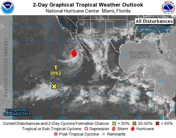
TROPICAL WEATHER OUTLOOK...CORRECTED
NWS NATIONAL HURRICANE CENTER MIAMI FL
500 PM PDT SAT SEP 6 2014

Corrected to describe existing disturbance first.

For the eastern North Pacific...east of 140 degrees west longitude:

The National Hurricane Center is issuing advisories on Hurricane
Norbert, located a short distance offshore of Baja California Sur.

1. Disorganized showers and thunderstorm centered about 1200 miles
south-southwest of the southern tip of the Baja California peninsula
are associated with a broad area of low pressure. Environmental
conditions are expected to become more conducive for some
development of this system by mid-week while it remains nearly
stationary.
* Formation chance through 48 hours...low...near 0 percent.
* Formation chance through 5 days...low...20 percent.

2. An area of low pressure is expected to form south or southwest of
the southern coast of Mexico by the early or middle part of next
week. Environmental conditions in this region should be conducive
for gradual development at that time.
* Formation chance through 48 hours...low...near 0 percent.
* Formation chance through 5 days...medium...50 percent.

Forecaster Blake
List of Atlantic Outlooks (May 2023 - present)
List of East Pacific Outlooks (May 2023 - present)
List of Central Pacific Outlooks (May 2023 - present)
List of Atlantic Outlooks (July 2014 - April 2023)
List of East Pacific Outlooks (July 2014 - April 2023)
List of Central Pacific Outlooks (June 2019 - April 2023)
List of Atlantic Outlooks (June 2009 - June 2014)
List of East Pacific Outlooks (June 2009 - June 2014)