


NHC Graphical Outlook Archive
|
« Earliest Available ‹ Earlier Later › Latest Available » |
GIS Shapefiles |
| Eastern North Pacific | Atlantic |
|
Tropical Weather Outlook Text
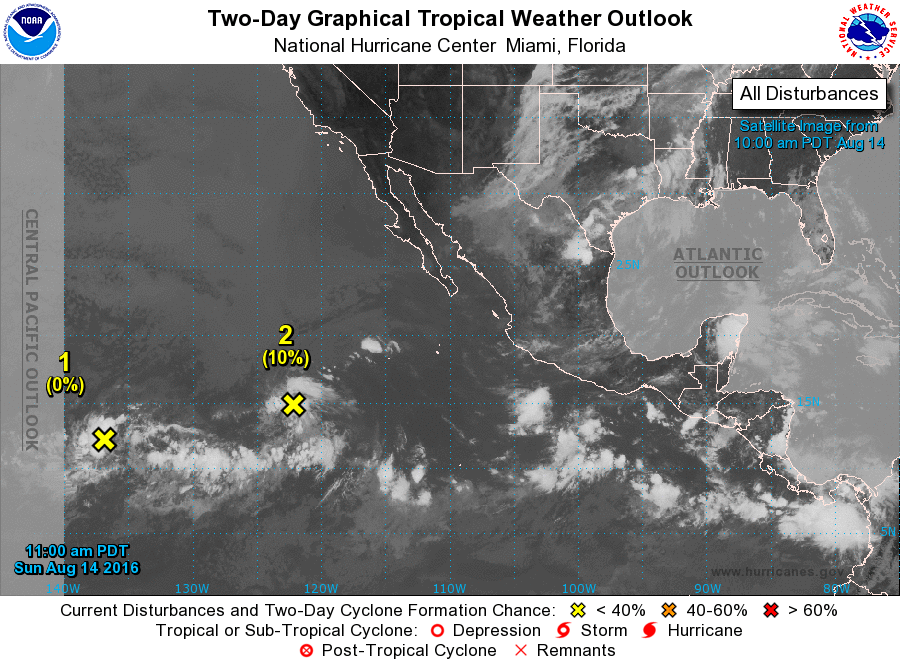
ZCZC MIATWOEP ALL
TTAA00 KNHC DDHHMM

TROPICAL WEATHER OUTLOOK
NWS NATIONAL HURRICANE CENTER MIAMI FL
1100 AM PDT SUN AUG 14 2016

For the eastern North Pacific...east of 140 degrees west longitude:

1. An area of disturbed weather located about 1300 miles east-southeast
of the Hawaiian Islands remains poorly organized.  A low pressure
area could form from this disturbance during the few days, but any
further development should be slow to occur.  This system is
forecast to move generally westward into the Central Pacific basin
by Monday.
* Formation chance through 48 hours...low...near 0 percent
* Formation chance through 5 days...low...10 percent

2. A concentrated area of showers located about 1000 miles southwest of
the southern tip of Baja California is associated with a weak area
of low pressure.  Environmental conditions are expected to become
increasingly less conducive for any additional development of this
system during the next couple of days while it moves generally
west-northwestward.
* Formation chance through 48 hours...low...10 percent
* Formation chance through 5 days...low...10 percent

Forecaster Kimberlain
List of Atlantic Outlooks (May 2023 - present)
List of East Pacific Outlooks (May 2023 - present)
List of Central Pacific Outlooks (May 2023 - present)
List of Atlantic Outlooks (July 2014 - April 2023)
List of East Pacific Outlooks (July 2014 - April 2023)
List of Central Pacific Outlooks (June 2019 - April 2023)
List of Atlantic Outlooks (June 2009 - June 2014)
List of East Pacific Outlooks (June 2009 - June 2014)