


NHC Graphical Outlook Archive
|
« Earliest Available ‹ Earlier Later › Latest Available » |
GIS Shapefiles |
| Eastern North Pacific | Atlantic |
|
Tropical Weather Outlook Text
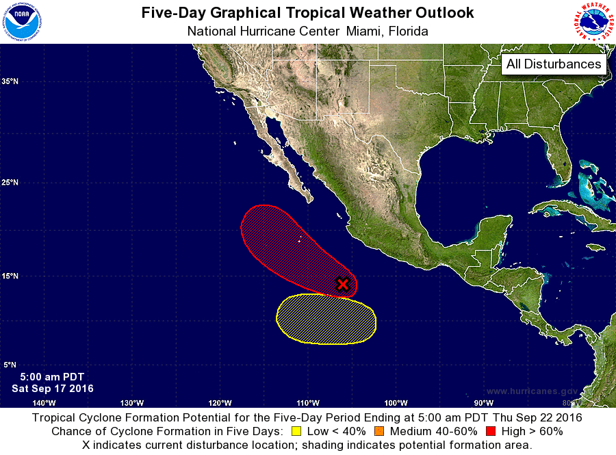
ZCZC MIATWOEP ALL
TTAA00 KNHC DDHHMM

TROPICAL WEATHER OUTLOOK
NWS NATIONAL HURRICANE CENTER MIAMI FL
500 AM PDT SAT SEP 17 2016

For the eastern North Pacific...east of 140 degrees west longitude:

1. A broad area of low pressure located about 400 miles south of
Manzanillo, Mexico, continues to produce a large area of showers
and thunderstorms.  Conditions are conducive for development, and a
tropical depression is expected to form later today or on Sunday
while this system moves west-northwestward at 10 to 15 mph a few
hundred miles offshore of the coast of Mexico.
* Formation chance through 48 hours...high...80 percent
* Formation chance through 5 days...high...90 percent

2. An area of low pressure could form early next week several hundred
miles southwest of southern Mexico.  Some gradual development is
possible by midweek while the system moves slowly westward.
* Formation chance through 48 hours...low...near 0 percent
* Formation chance through 5 days...low...20 percent

Forecaster Beven
List of Atlantic Outlooks (May 2023 - present)
List of East Pacific Outlooks (May 2023 - present)
List of Central Pacific Outlooks (May 2023 - present)
List of Atlantic Outlooks (July 2014 - April 2023)
List of East Pacific Outlooks (July 2014 - April 2023)
List of Central Pacific Outlooks (June 2019 - April 2023)
List of Atlantic Outlooks (June 2009 - June 2014)
List of East Pacific Outlooks (June 2009 - June 2014)