


NHC Graphical Outlook Archive
|
« Earliest Available ‹ Earlier Later › Latest Available » |
GIS Shapefiles |
| Central Pacific | Eastern Pacific | Atlantic |
|
Tropical Weather Outlook Text
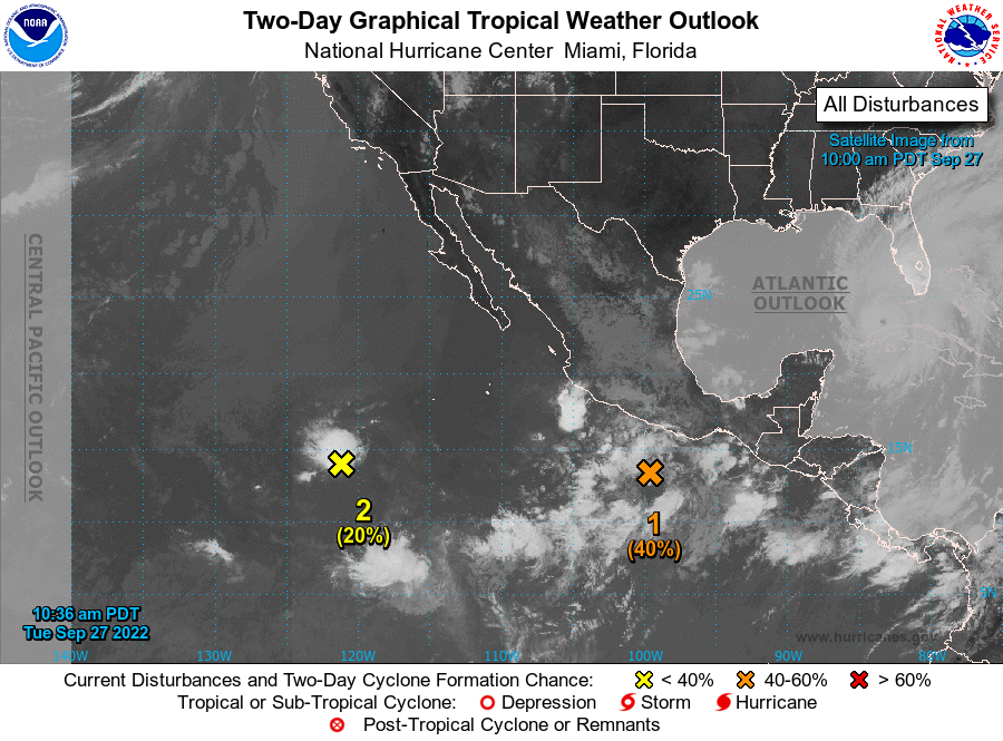
ZCZC MIATWOEP ALL
TTAA00 KNHC DDHHMM

Tropical Weather Outlook
NWS National Hurricane Center Miami FL
1100 AM PDT Tue Sep 27 2022

For the eastern North Pacific...east of 140 degrees west longitude:

1. South of the Southern Coast of Mexico:
An area of low pressure located south of the southern coast of
Mexico continues to produce a broad area of disorganized showers
and thunderstorms. Environmental conditions appear conducive for
additional development, and a tropical depression is likely to form
by the end of this week while the system moves westward to
west-northwestward off the coast of southern and southwestern
Mexico.
* Formation chance through 48 hours...medium...40 percent.
* Formation chance through 5 days...high...80 percent.

2. Western East Pacific:
The remnants of Newton continue to produce disorganized bursts of
showers and thunderstorms. Some slow development of this system is
possible over the next couple of days as it moves generally westward
over the western portion of the East Pacific basin. By late this
week, environmental conditions are expected to become unfavorable
for further development.
* Formation chance through 48 hours...low...20 percent.
* Formation chance through 5 days...low...20 percent.

Forecaster Papin
List of Atlantic Outlooks (May 2023 - present)
List of East Pacific Outlooks (May 2023 - present)
List of Central Pacific Outlooks (May 2023 - present)
List of Atlantic Outlooks (July 2014 - April 2023)
List of East Pacific Outlooks (July 2014 - April 2023)
List of Central Pacific Outlooks (June 2019 - April 2023)
List of Atlantic Outlooks (June 2009 - June 2014)
List of East Pacific Outlooks (June 2009 - June 2014)