Tropical Cyclone Climatology
Contents
- Overview
- Atlantic & Eastern Pacific
- Seasonal Tropical Cyclone Activity
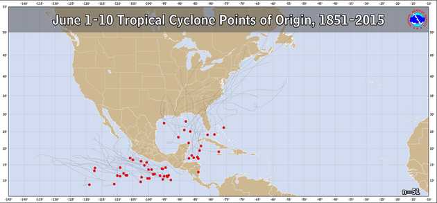
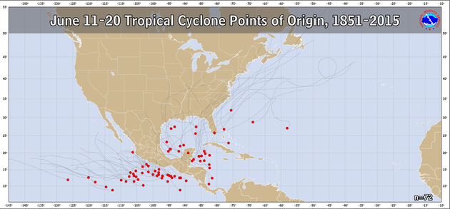
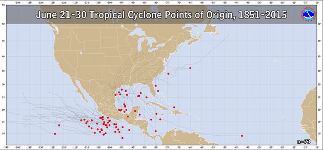
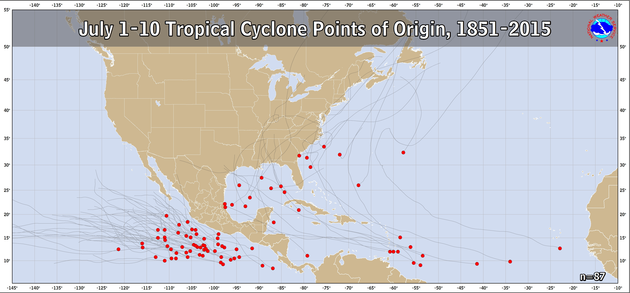
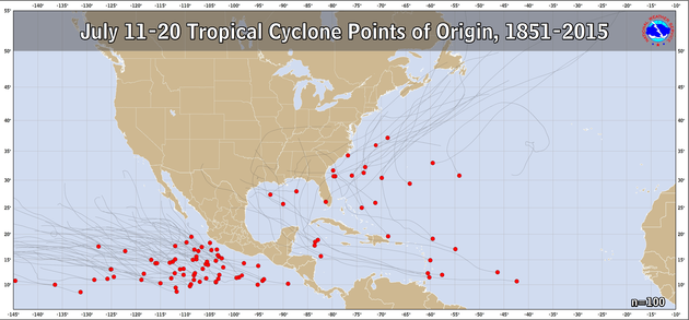
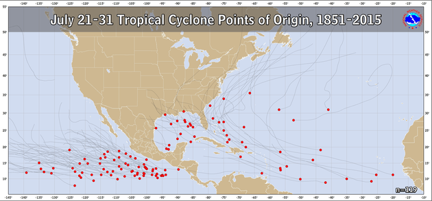
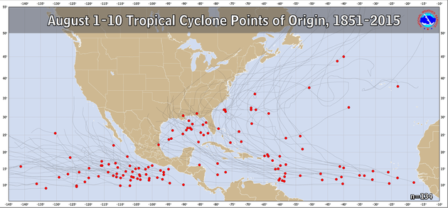
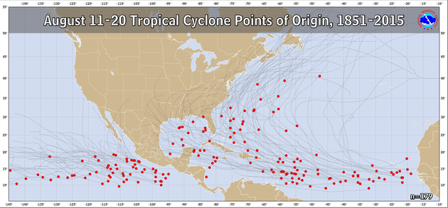
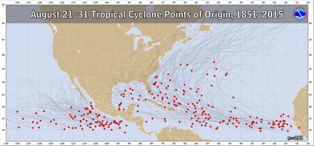
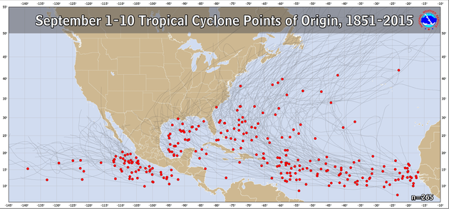
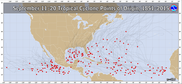
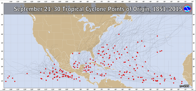
- Origins by 10-day Period
- Origins & Tracks by Month
- High Resolution History Maps
- Named Cyclones by Year
- U.S. Hurricane Return Periods
- CONUS Hurricane Strikes
- Central Pacific Climatology
Overview
A tropical cyclone is a rotating, organized system of clouds and thunderstorms that originates over tropical or subtropical waters and has a closed low-level circulation. Tropical cyclones rotate counterclockwise in the Northern Hemisphere. They are classified as follows:
- Tropical Depression: A tropical cyclone with maximum sustained winds of 38 mph (33 knots) or less.
- Tropical Storm: A tropical cyclone with maximum sustained winds of 39 to 73 mph (34 to 63 knots).
- Hurricane: A tropical cyclone with maximum sustained winds of 74 mph (64 knots) or higher. In the western North Pacific, hurricanes are called typhoons; similar storms in the Indian Ocean and South Pacific Ocean are called cyclones.
- Major Hurricane: A tropical cyclone with maximum sustained winds of 111 mph (96 knots) or higher, corresponding to a Category 3, 4 or 5 on the Saffir-Simpson Hurricane Wind Scale.
Tropical cyclones forming between 5 and 30 degrees North latitude typically move toward the west. Sometimes the winds in the middle and upper levels of the atmosphere change and steer the cyclone toward the north and northwest. When tropical cyclones reach latitudes near 30 degrees North, they often move northeast.
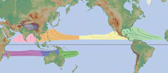
Tropical Cyclone formation regions with mean tracks (courtesy of the NWS JetStream Online School)
Atlantic and Eastern Pacific Hurricane Season Normal Activity
The Atlantic hurricane season runs from June 1 to November 30. The Atlantic basin includes the Atlantic Ocean, Caribbean Sea, and Gulf of America. Based on a 30-year climate period from 1991 to 2020, an average Atlantic hurricane season has 14 named storms, 7 hurricanes, and 3 major hurricanes (Category 3, 4, or 5 on the Saffir-Simpson Hurricane Wind Scale). The first named storm typically forms in mid to late June, the first hurricane tends to form in early to mid-August, and the first major hurricane forms in late August or early September.
The eastern Pacific hurricane season runs from May 15 to November 30. The eastern Pacific basin extends from Mexico and Central America westward to 140°W. Based on a 30-year climate period from 1991 to 2020, an average eastern Pacific hurricane season has 15 named storms, 8 hurricanes, and 4 major hurricanes. The first named storm typically forms in early to mid-June, the first hurricane tends to form in late June, and the first major hurricane forms in mid-July.
The following tables describe the progress of typical hurricane seasons in the Atlantic and eastern Pacific basins by showing benchmark dates when a given number of named storms, hurricanes, and major hurricanes typically forms. It is important to note, however, that formation dates in individual hurricane seasons could vary considerably from these average dates.
| Number | Named systems | Hurricanes | Major Hurricanes |
|---|---|---|---|
| 1 | Jun 20 | Aug 11 | Sep 1 |
| 2 | Jul 17 | Aug 26 | Sep 19 |
| 3 | Aug 3 | Sep 7 | Oct 28 |
| 4 | Aug 15 | Sep 16 | - |
| 5 | Aug 22 | Sep 28 | - |
| 6 | Aug 29 | Oct 15 | - |
| 7 | Sep 3 | Nov 15 | - |
| 8 | Sep 9 | - | - |
| 9 | Sep 16 | - | - |
| 10 | Sep 22 | - | - |
| 11 | Oct 2 | - | - |
| 12 | Oct 11 | - | - |
| 13 | Oct 25 | - | - |
| 14 | Nov 19 | - | - |
| Number | Named systems | Hurricanes | Major Hurricanes |
|---|---|---|---|
| 1 | Jun 10 | Jun 26 | Jul 15 |
| 2 | Jun 24 | Jul 15 | Aug 15 |
| 3 | Jul 6 | Jul 31 | Sep 13 |
| 4 | Jul 15 | Aug 16 | Oct 22 |
| 5 | Jul 23 | Aug 31 | - |
| 6 | Aug 3 | Sep 15 | - |
| 7 | Aug 11 | Sep 28 | - |
| 8 | Aug 21 | Oct 23 | - |
| 9 | Aug 28 | - | - |
| 10 | Sep 4 | - | - |
| 11 | Sep 14 | - | - |
| 12 | Sep 21 | - | - |
| 13 | Oct 2 | - | - |
| 14 | Oct 15 | - | - |
| 15 | Nov 5 | - | - |
Seasonal Tropical Cyclone Activity
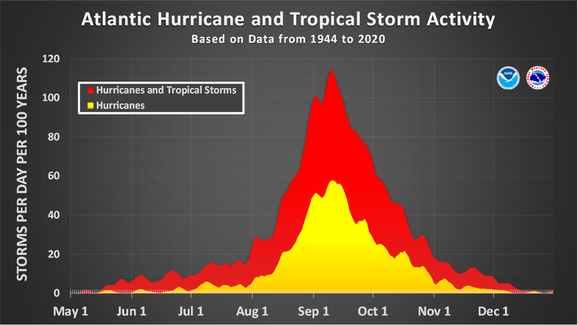
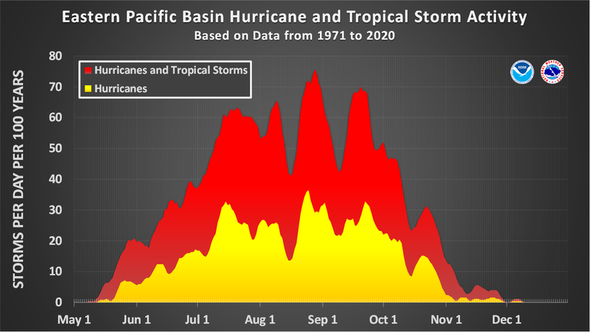
These charts show the amount of tropical cyclone activity, in terms of named storms and hurricanes, that occurs in the Atlantic and east Pacific basins on each calendar day between May 1 and December 31. Specifically, they show the number of hurricanes (yellow area), and combined named storms and hurricanes (red area) that occur on each calendar day over a 100-year period. The data have been smoothed using a 5-day running average centered on each calendar day.
For the Atlantic basin (the Atlantic Ocean, the Caribbean Sea, and the Gulf of America), the chart is based on data from the 77-year period from 1944 to 2020 (starting at the beginning of the aircraft reconnaissance era) but normalized to 100 years. The official hurricane season for the Atlantic basin is from June 1 to November 30, but tropical cyclone activity sometimes occurs before and after these dates, respectively. The peak of the Atlantic hurricane season is September 10, with most activity occurring between mid-August and mid-October.
For the eastern Pacific basin, the analyses are based on data from the 50-year period from 1971 to 2020 (starting when there was reliable satellite imagery) but also normalized to 100 years. The official hurricane season for the eastern Pacific basin is from May 15 to November 30, but tropical cyclones occasionally occur before and after these dates, respectively. A peak in activity is noted in late August, but this peak is less pronounced than the peak in Atlantic activity. Relatively high levels of activity in the eastern Pacific tend to be spread out over a longer portion of the season than in the Atlantic, with most tropical cyclones occurring between late June and early October.
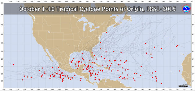
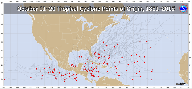
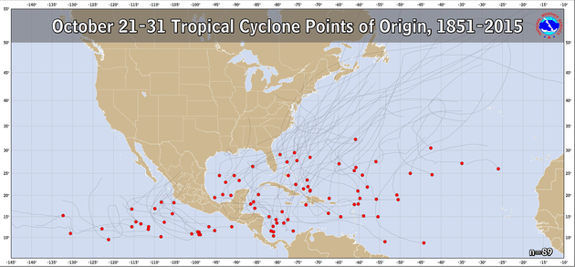
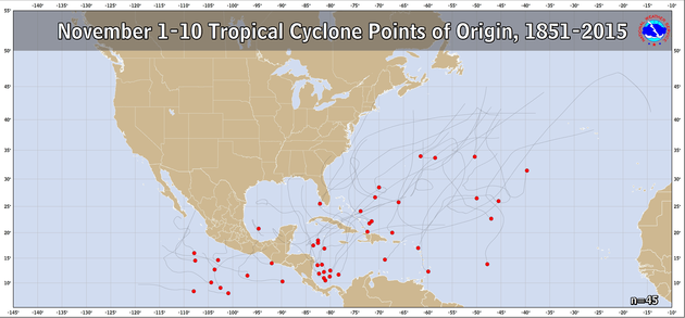
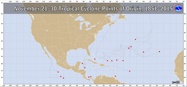
Points of Origin by 10-Day Period
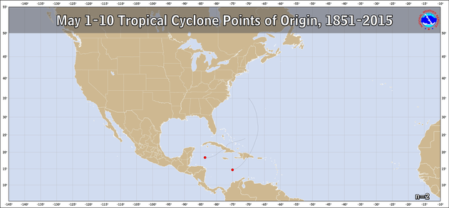
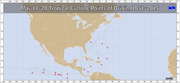
The figures below show the points of tropical cyclone genesis by 10-day periods during the hurricane season. The source years include 1851-2024 for the Atlantic and 1949-2024 for the Eastern Pacific from the HURDAT database.
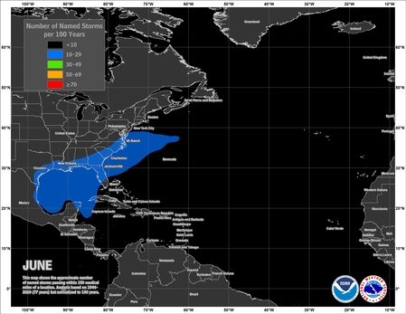
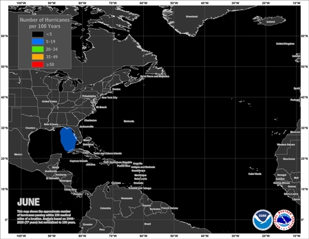
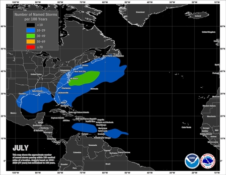
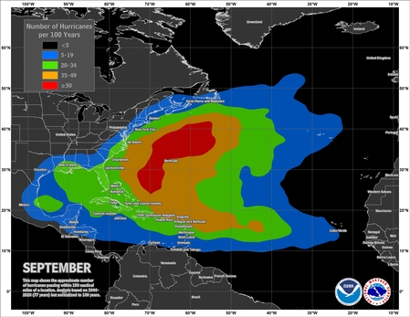
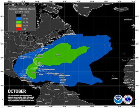
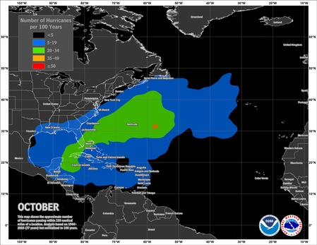
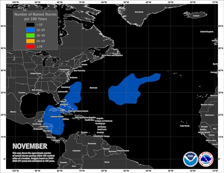
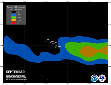
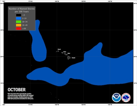
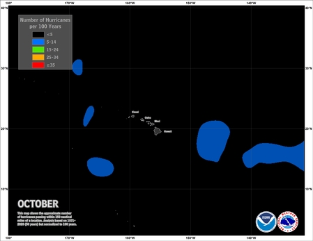
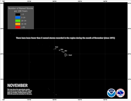
Typical Tropical Cyclone Occurrence Areas by Month
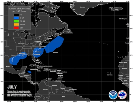
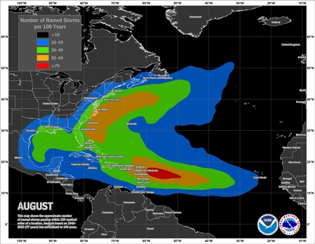
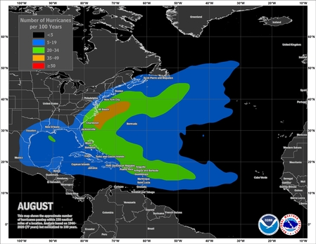
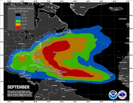
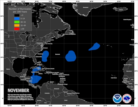
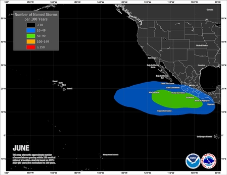
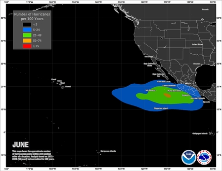
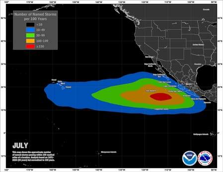
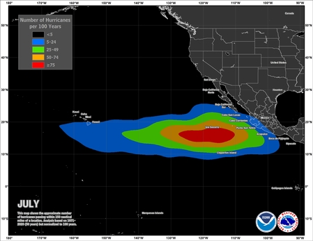
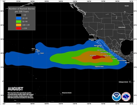
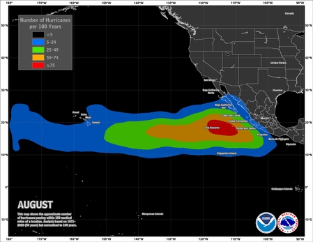
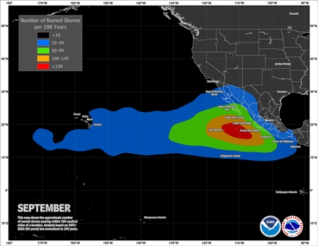
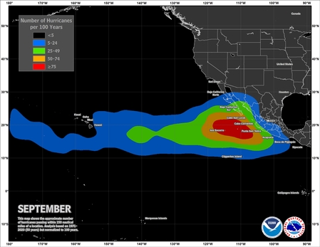
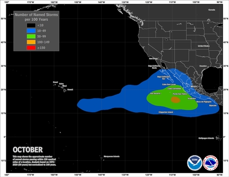
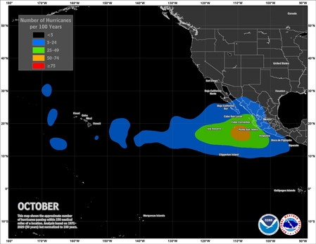
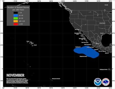
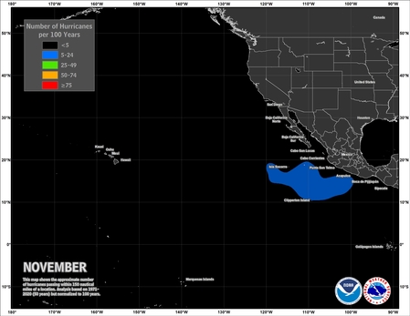
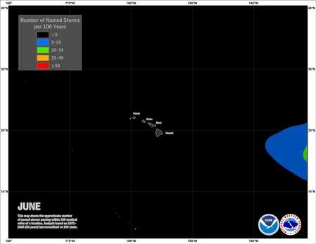
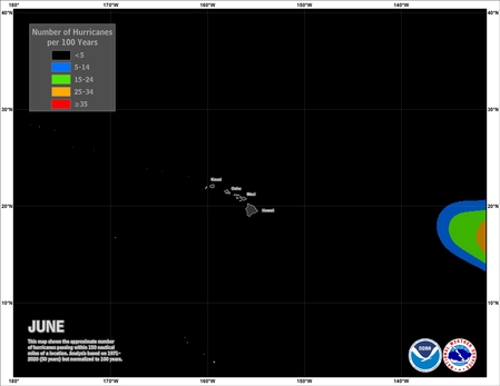
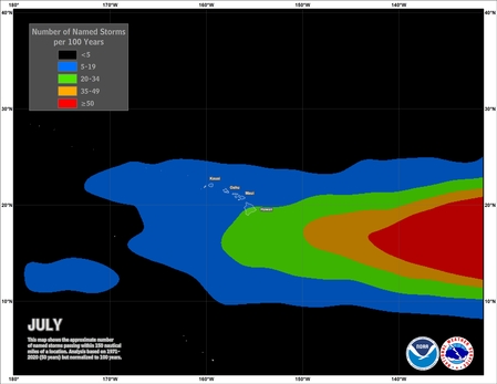
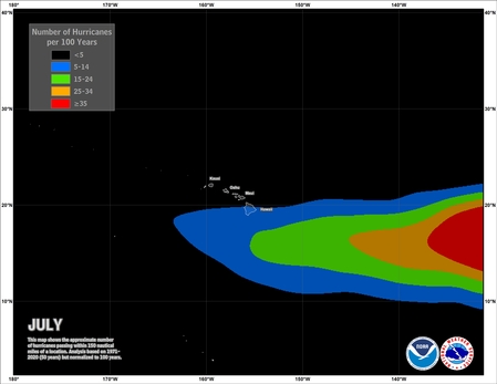
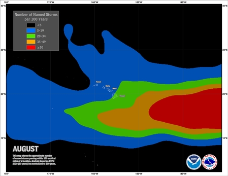
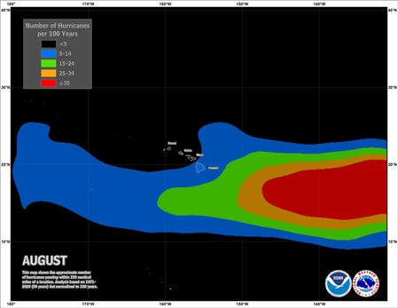
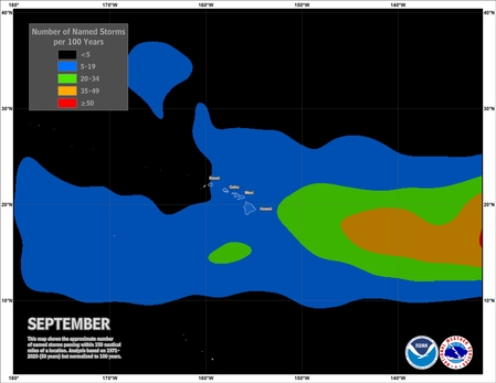
These maps show where tropical cyclones (named storms and hurricanes) tend to occur during each month of the hurricane season. The data are shown as the number of named storms or hurricanes whose centers pass within 150 nautical miles of a point on the map during a 100-year period. For the Atlantic basin, the analyses are based on data from the 77-year period from 1944 to 2020 (starting at the beginning of the aircraft reconnaissance era) but normalized to 100 years. For the eastern and central Pacific basins, the analyses are based on data from the 50-year period from 1971 to 2020 (starting when there was reliable satellite imagery) but also normalized to 100 years. Please note that the map legends vary from basin to basin and between named storms and hurricanes (but not between months) in order to make climatological patterns more apparent.
Atlantic Named Storms |
Atlantic Hurricanes |
Eastern and Central Pacific Named Storms |
Eastern and Central Pacific Hurricanes |
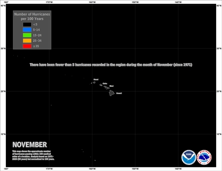
Central Pacific Named Storms |
Central Pacific Hurricanes |
GIS files for Tropical Cyclone Occurrence Areas (KMZ format)
High Resolution History Maps
![[Tropical Cyclone History Map for Atlantic and Eastern Pacific]](images/1851_2017_allstorms_sm.jpg)
All North Atlantic and Eastern North Pacific tropical cyclones
Named Cyclones by Year
![[Graph of Tropical Cyclone Activity in the Atlantic Basin]](images/Atlantic_Storm_Count.jpg)
Bars depict number of named systems (yellow), hurricanes (red), and category 3 or greater (purple), 1850-2024
Download hires image
Download table of data (PDF)
Hurricane Return Periods
Hurricane return periods are the frequency at which a certain intensity of hurricane can be expected within a given distance of a given location (for the below images 50 nm or 58 statute miles). In simpler terms, a return period of 20 years for a major hurricane means that on average during the previous 100 years, a Category 3 or greater hurricane passed within 50 nm (58 miles) of that location about five times. We would then expect, on average, an additional five Category 3 or greater hurricanes within that radius over the next 100 years.
More information on return periods can be found from NOAA Technical Memorandum NWS NHC 38 (pdf) on the NHC Risk Analysis Program (HURISK).
Note: The information on return period is generated with the 1987 HURISK program, but uses data through 2010.
![[Map of return period in years for hurricanes passing within 50 nautical miles]](images/return_hurr_sm.jpg)
Estimated return period in years for hurricanes passing
within 50 nautical miles of various locations on the U.S. Coast
![[Map of return period in years for major hurricanes passing within 50 nautical miles]](images/return_mjrhurr_sm.jpg)
Estimated return period in years for major hurricanes passing
within 50 nautical miles of various locations on the U.S. Coast
CONUS Hurricane Strikes
![[Map of 1950-2021 CONUS Hurricane Strikes]](images/conus_strikes_sm.png)
1950-2023 CONUS Hurricane Strikes (Courtesy of NCEI)
CONUS Hurricane Strike Density (county maps)
![[Map of 1900-2010 Hurricane Strikes by U.S. counties/parishes]](images/strikes_us_sm.jpg)
1900-2010 U.S. Hurricane Strikes
![[Map of 1900-2010 Hurricane Strikes by U.S. counties/parishes (West Gulf)]](images/strikes_wgulf_sm.jpg)
1900-2010 U.S. Hurricane Strikes - West Gulf
![[Map of 1900-2010 Hurricane Strikes by U.S. counties/parishes (East Gulf)]](images/strikes_egulf_sm.jpg)
1900-2010 U.S. Hurricane Strikes - East Gulf
![[Map of 1900-2010 Hurricane Strikes by U.S. counties/parishes (Southeast)]](images/strikes_se_sm.jpg)
1900-2010 U.S. Hurricane Strikes - Southeast
![[Map of 1900-2010 Hurricane Strikes by U.S. counties/parishes (Northeast)]](images/strikes_ne_sm.jpg)
1900-2010 U.S. Hurricane Strikes - Northeast
![[Map of 1900-2010 Major Hurricane Strikes by U.S. counties/parishes]](images/strikes_us_mjr_sm.jpg)
1900-2010 U.S. Major Hurricane Strikes
![[Map of 1900-2010 Major Hurricane Strikes by U.S. counties/parishes (West Gulf)]](images/strikes_wgulf_mjr_sm.jpg)
1900-2010 U.S. Major Hurricane Strikes - West Gulf
![[Map of 1900-2010 Major Hurricane Strikes by U.S. counties/parishes (East Gulf)]](images/strikes_egulf_mjr_sm.jpg)
1900-2010 U.S. Major Hurricane Strikes - East Gulf
![[Map of 1900-2010 Major Hurricane Strikes by U.S. counties/parishes (Southeast)]](images/strikes_se_mjr_sm.jpg)
1900-2010 U.S. Major Hurricane Strikes - Southeast
![[Map of 1900-2010 Major Hurricane Strikes by U.S. counties/parishes (Northeast)]](images/strikes_ne_mjr_sm.jpg)
1900-2010 U.S. Major Hurricane Strikes - Northeast
Central Pacific Climatology
The following graphs and charts describe some of the climatology of tropical cyclone activity in the area served by the Central Pacific Hurricane Center, between 140 degrees West longitude and the International Date Line and north of the equator.
Many factors affect the level of tropical cyclone activity from year to year. Among them are the state of the El Nino Southern Oscillation in the Pacific. Moderate to strong El Nino years are correlated with increased tropical cyclone activity in the Central Pacific and the occurrence of late season storms.
Continuous satellite coverage has been available in the Central Pacific since 1971 so many climatologies start with that date.Earlier accounts of tropical cyclone activity are based on land, ship, and aircraft observations as well as some non-continuous satellite data.
| Hurricanes | Tropical Storms | Tropical Depressions | Total | |
|---|---|---|---|---|
| Total Number | 58 | 46 | 59 | 163 |
| Percent of All Systems | 36% | 28% | 36% |
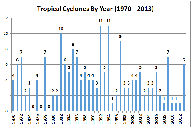
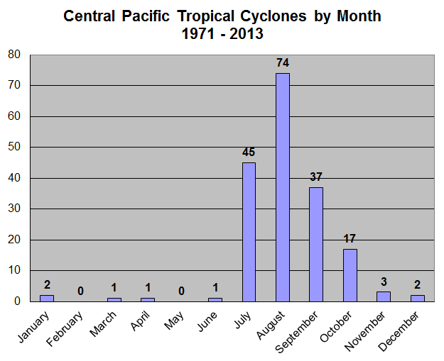
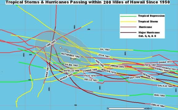
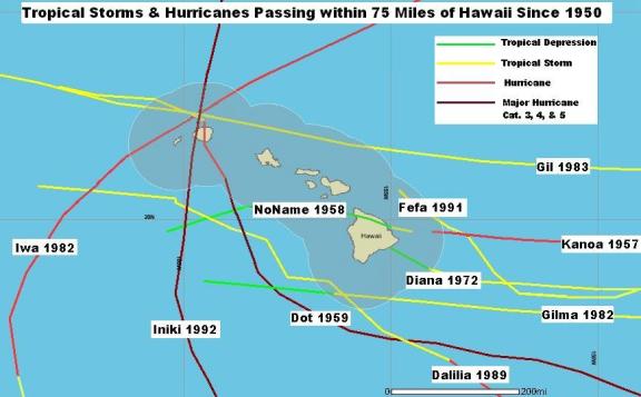
The following charts show the storms that have come within 200 miles and 75 miles of Hawaii. Storms that do not make landfall in Hawaii can still cause considerable damage, mostly from winds and surf.
Learn more about climate impacts from the NWS Climate Prediction Center.


