Tropical Storm DEBBY Storm Surge Exceedance
|
|
|
|
|
|
Lat: Lon:
|
|

|
Disclaimer Historical Data: NHC this storm NHC all storms MDL |
|
|
|
|
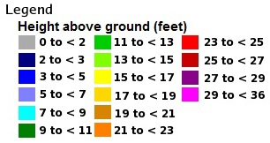
Description: This application shows storm surge height including tides, in feet above ground level (AGL), such that there is an N percent chance of exceeding it, where N ranges from 10 to 90 in intervals of 10 percent. The 10 percent exceedance height, for example, is the storm surge height including tides, above ground level, such that there is a 10 percent chance of exceeding it. This graphic is based upon an ensemble of Sea, Lake, and Overland Surge from Hurricanes (SLOSH) model runs using the National Hurricane Center (NHC) official advisory and account for track, size, and intensity uncertainty from historical errors. Additional information on the SLOSH model can be found at: http://www.nhc.noaa.gov/surge/slosh.php. The emergency management community is the primary target audience. However, this product will also be widely used by other federal, state, and local government agencies; the media; maritime interests; and the general public. Backup Availability and Archive: In the event NHC has difficulty creating the storm surge images, the Meteorological Development Laboratory's Probabilistic Hurricane Storm Surge website maintains the same information. An archive of storm surge products is also available from the MDL website. |
|


